


Click Image to Enlarge
Texas Counties
Texas is divided into two hundred and fifty-four counties, more than any other state. Texas was originally divided into municipalities, a unit of local government under Spanish and Mexican rule. When the Republic of Texas gained its independence in 1836, there were 23 municipalities, which became the original Texas counties. Many of these would later be divided into new counties. The most recent county to be created was Kenedy County in 1921. The most recent county to be organized was Loving County in 1931Llano County, Texas
Llano County Education, Geography, and History
Llano County is a county located on the Edwards Plateau in the state of Texas. Based on the 2010 census, its population was 19,301. Its county seat is Llano, and the county is named for the Llano River.
Etymology - Origin of Llano County Name
the Llano River; Llano is Spanish for plains
Demographics:
County QuickFacts: CensusBureau Quick Facts
Llano County History
Llano County (pronounced /ˈl?oʊ/) is a county located in the US state of Texas. Its county seat is Llano, and the county is named for the Llano River.
Handbook of Texas Online
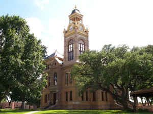
Llano County was organized in 1856 after the Texas legislature formed the county from the Bexar District and
Gillespie County. Donations of 250 acres were made for a site for the county seat. By 1858 the population exceeded
1,000, and cattle, hides, and pecans were being exported. Farming was the chief occupation in the north and ranching
in the south. Germans predominated in the western parts and Anglo-Americans in
the other areas. By 1860 the county had eighty-nine farms, encompassing 59,744 acres. The agricultural census that
year reported 21,344 cattle and 1,492 sheep in Llano County, and the corn harvest exceeded 23,500 bushels. The
United States census found 1,101 people living in the county that year; of these, 21 were slaveholders and 54 were
slaves More at
Ernest B. Speck, "LLANO COUNTY," Handbook of Texas Online (http://www.tshaonline.org/handbook/online/articles/hcl12),
accessed January 24, 2016. Uploaded on June 15, 2010. Published by the Texas State Historical Association.
Geography: Land and Water
As reported by the Census Bureau, the county has a total area of 966 square miles (2,502 km2). 2,421 km2 (935
sq. mi.) of it is land and 81 km2 (31 sq. mi.) of it (3.25%) is water.
Enchanted Rock, a designated state natural area and popular tourist destination, is located in southern Llano
county.
Two significant rivers, the Llano River and the Colorado River, flow through Llano County. These rivers contribute
to Lake Buchanan, Inks Lake, and Lake Lyndon B. Johnson, which are all located partially within the county.
Neighboring Counties
Bordering counties are as follows:
- San Saba County (north)
- Burnet County (east)
- Blanco County (southeast)
- Gillespie County (south)
- Mason County (west)
Education


Click Image to Enlarge
