


Click Image to Enlarge
Texas Counties
Texas is divided into two hundred and fifty-four counties, more than any other state. Texas was originally divided into municipalities, a unit of local government under Spanish and Mexican rule. When the Republic of Texas gained its independence in 1836, there were 23 municipalities, which became the original Texas counties. Many of these would later be divided into new counties. The most recent county to be created was Kenedy County in 1921. The most recent county to be organized was Loving County in 1931Milam County, Texas
Milam County Education, Geography, and History
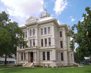
Milam County is a county located in the state of Texas. Based on the 2010 census, its population was 24,757. The county seat is Cameron. The county was created in 1834 as a municipality in Mexico and organized as a county in 1837. Milam County is named for Benjamin Rush Milam, an early settler and a soldier in the Texas Revolution.
Etymology - Origin of Milam County Name
Benjamin Rush Milam, an early Texas colonizer and soldier in the early Texas Revolution, who was killed in a successful siege of San Antonio, Texas
Demographics:
County QuickFacts: CensusBureau Quick Facts
Milam County History
Milam County is a county located in the US state of Texas. Milam County is named for Benjamin Rush Milam, an early settler and a soldier in the Texas Revolution. The seat of the county is Cameron
Handbook of Texas Online
Robert Leftwich, a representative for the Texas Association of Nashville,
Tennessee, obtained a colonization grant from Mexico in 1825 that included the Milam County area. The grant's
boundaries followed the Navasota River, turned southwest along the San Antonio road to the divide between the Brazos
and the Colorado rivers, then northwest to the Comanche Trail, and east back to
the Navasota. Sterling Robertson assumed leadership of the colonization effort
in 1827, but in 1830, because the company had made no progress in settling the area, the contract was suspended. The
following year Stephen F. Austin and his partner, Samuel May Williams,
persuaded the Mexican government to transfer the grant to them. In 1834, with Austin out of favor with the Mexican
government, Robertson regained control of the grant, and actual settlement of the region began. The colony was known
to the Mexican government as the Municipality of Viesca, but in 1835 the legislative body of the Provisional
Government of Texas renamed it the Municipality of Milam,
in honor of Benjamin Rush Milam. It was during the first Congress of the
Republic of Texas that the municipality came to be called Milam County. At that
time the boundaries of the county were roughly the same as those of the colony granted to Leftwich, comprising
one-sixth of the land area of Texas. In addition to the present Milam County, the counties of Bell, Bosque,
Burleson, Coryell, Erath, Falls, Hamilton, Hood, Jones, McLennan, Robertson, Shackelford, Somervell, Stephens, and
Williamson were eventually carved out of the original Milam County. Brazos, Brown, Burnet, Callahan, Comanche,
Eastland, Haskell, Hill, Johnson, Lampasas, Lee, Limestone, Mills, Palo Pinto, Parker, Stonewall, Throckmorton, and
Young counties also received land from Milam County. By 1850, with the exception of a small area between Williamson
and Bell counties, Milam County had been reduced to its present size. More at
Cecil Harper, Jr., and Vivian Elizabeth Smyrl, "MILAM COUNTY," Handbook of Texas Online (http://www.tshaonline.org/handbook/online/articles/hcm13),
accessed January 24, 2016. Uploaded on June 15, 2010. Modified on August 19, 2014. Published by the Texas State Historical Association.
Geography: Land and Water
As reported by the Census Bureau, the county has a total area of 1,022 square miles (2,646 km2), of which,
1,017 square miles (2,633 km2) of it is land and 5 square miles (13 km2) of it (0.48%) is water.
Neighboring Counties
Bordering counties are as follows:
- Falls County (north)
- Robertson County (northeast)
- Burleson County (southeast)
- Lee County (south)
- Williamson County (southwest)
- Bell County (northwest)
Education
Six Independent School Districts (ISDs) are headquartered in Milam County:
Four additional districts extend into parts of Milam County, but are based in neighboring counties: Bartlett, Caldwell, Holland, and
Rosebud-Lott.
St. Paul Lutheran School in Thorndale is a private institution that serves students in grades pre-kindergarten through eight.


Click Image to Enlarge
