


Click Image to Enlarge
Texas Counties
Texas is divided into two hundred and fifty-four counties, more than any other state. Texas was originally divided into municipalities, a unit of local government under Spanish and Mexican rule. When the Republic of Texas gained its independence in 1836, there were 23 municipalities, which became the original Texas counties. Many of these would later be divided into new counties. The most recent county to be created was Kenedy County in 1921. The most recent county to be organized was Loving County in 1931Parker County, Texas
Parker County Education, Geography, and History
Parker County is a county located in the state of Texas. Based on the 2010 census, its population was 116,927. The county seat is
Weatherford. The county was created in 1855 and organized the following year. It is named for Isaac Parker, a state legislator who introduced
the bill that established the county in 1855.
Parker County is included in the Dallas-Fort Worth-Arlington, TX Metropolitan Statistical Area.
Etymology - Origin of Parker County Name
Isaac Parker, an early legislator in the state (also was the uncle of Cynthia Ann Parker and, thus, the great-uncle of Quanah Parker)
Demographics:
County QuickFacts: CensusBureau Quick Facts
Parker County History
Parker County is a county located in the US state of Texas. Parker County is named for Isaac Parker, a state legislator who introduced the bill that established the county. The seat of the county is Weatherford.
Handbook of Texas Online
No effort was made to colonize the area that is now Parker County area under Spanish or Mexican rule, although
parts of the county were part of an early land grant from Stephen F. Austin and Samuel May Williams. Kiowas and Comanches controlled the area in the late 1840s, when settlers of European descent began moving into the
region on trails along the Brazos that had previously been established by the Indians. Immigration to the area was
encouraged during the early 1850s by an outbreak of malaria in Tarrant, Denton, and Collin counties, and by the
establishment of the Butterfield Overland Mail route in 1855. Under the
leadership of Isaac Parker 224 settlers in the area signed a petition requesting the establishment of a new county,
and in December 1855 the state legislature formed Parker County from Bosque and Navarro counties. Weatherford was
designated as the county seat, and by 1858 the town had a new two-story brick courthouse surrounded by a handful of
cabins and tents. By the late 1850s post offices had been established in the county at Weatherford, Ashville, Cooper
Hill, Cream Level (later known as Veal's Station), and Newburg. The county's first flour mill was built in 1859;
another was established in 1860. The new settlers were often harassed by Indian raids. The county's first newspaper,
the Frontier News, began publication in 1858. Another paper, the Whiteman,
moved to Weatherford in October 1860. This newspaper, published by John Robert Baylor
and J. Hamner, was dedicated to the frontier and its defense against Indians, abolitionists, and horse thieves. It
apparently ceased publication in December 1860. That year 4,213 people, including 222 slaves, were living in the
county. The agricultural census counted 397 farms and ranches of three acres or larger in the county that year, as
well as more than 14,000 cattle and about 4,000 sheep. "Improved" acres numbered almost 13,000. County farmers
produced more than 79,000 bushels of corn and almost 22,000 bushels of wheat, along with smaller crops of rye,
potatoes, and sweet potatoes More at
Jeri Echeverria, "PARKER COUNTY," Handbook of Texas Online (http://www.tshaonline.org/handbook/online/articles/hcp03),
accessed January 24, 2016. Uploaded on June 15, 2010. Published by the Texas State Historical Association.
Geography: Land and Water
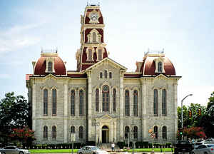
The Parker County courthouse in Weatherford. As reported by the Census Bureau, the county has a total area of
910 square miles (2,357 km2). 904 square miles (2,341 km2) of it is land and 7 square miles (18 km2) of it (0.72%)
is water.
Neighboring Counties
Bordering counties are as follows:
- Wise County (north)
- Tarrant County (east)
- Johnson County (southeast)
- Hood County (south)
- Palo Pinto County (west)
- Jack County (northwest)
Education


Click Image to Enlarge
