


Click Image to Enlarge
Texas Counties
Texas is divided into two hundred and fifty-four counties, more than any other state. Texas was originally divided into municipalities, a unit of local government under Spanish and Mexican rule. When the Republic of Texas gained its independence in 1836, there were 23 municipalities, which became the original Texas counties. Many of these would later be divided into new counties. The most recent county to be created was Kenedy County in 1921. The most recent county to be organized was Loving County in 1931Presidio County, Texas
Presidio County Education, Geography, and History
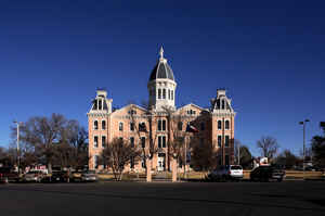
Presidio County is a county located in the state of Texas. Based on the 2010 census, its population was 7,818. Its county seat is Marfa. The
county was created in 1850 and later organized in 1875.
Presidio County (K-5 in Texas topological index of counties) is in the Trans-Pecos region of West Texas and is named for the ancient border
settlement of Presidio del Norte. It is east from the Mexican border.
Etymology - Origin of Presidio County Name
Presidio del Norte, an eighteenth-century fort and settlement on the south side of the Rio Grande
Demographics:
County QuickFacts: CensusBureau Quick Facts
Presidio County History
Paleo-Indians Hunter-gatherers existed thousands of years ago on the Trans-Pecos, and often did not adapt to
culture clashes, European diseases and colonization. The Masames tribe was exterminated by the Tobosos, circa 1652. The Nonojes suffered from
clashes with the Spanish and merged with the Tobosos. The Spanish made slave raids to the La Junta de los Rios, committing cruelties against
the native population. The Suma-Jumano tribe sought to align themselves with the Spanish for survival. The tribe later merged with the Apache
people. Foraging peoples who did not survive the 18th Century include the Chisos, Mansos, Jumanos, Conchos, Julimes, Cibolos, Tobosos, Sumas,
Cholomes, Caguates, Nonojes, Cocoyames, and Acoclames.
The entrada of Juan Dominguez de Mendoza and Father Nicolas Lopez in 1683?#8364;"84 set out from El Paso to La Junta where they established seven
missions at seven pueblos. In 1683 Father Lopez celebrated the first Christmas Mass ever observed in Texas at La Junta.
In 1832, Jose Ygnacio Ronquillo was issued a conditional land grant, and established the county?#8364;™s first white settlement on Cibolo Creek.
Military obligations forced him to abandon the settlement, and then sold the land.
The Chihuahua Trail connecting Mexico's state of Chihuahua with Santa Fe, New Mexico opened up in 1839.
By 1848 Ben Leaton built Fort Leaton, sometimes called the largest adobe structure in Texas, on the river as his home, trading post, and
private bastion. Leaton died in debt in 1851, with the fort passing to the holder of the mortgage, John Burgess. In 1934 T. C. Mitchell and
the Marfa State Bank acquired the old structure and donated it to the county as a historic site. The park was opened to the public in 1978.
Milton Faver became the county's first cattle baron. In 1857, he moved his family to Chinati Mountains in the county. Faver bought small
tracts of land around three springs-Cibolo, Cienega, and La Morita and established cattle ranches. He built Fort Cienega and Fort Cibolo.
Presidio County was established from Bexar County on January 3, 1850. Fort Leaton became the county seat. The county was organized in 1875 as
the largest county in the United States, with 12,000 square miles (31,000 km2). Fort Davis was named the county seat. The boundaries and seat
of Presidio County were changed in the 1880s. Marfa was established in 1883, and the county seat was moved there from Fort Davis in 1885.
Handbook of Texas Online
The first sighting of the phenomenal Marfa Lights was recorded in 1883 when
Robert Reed Ellison came through Paisano Pass and saw the mysterious lights. On any clear night they are still
visible between Marfa and Paisano Pass. The lights at times appear colored as they twinkle in the distance. They
move about, split apart, melt together, disappear, and reappear. The source of the lights and the reason for their
movements have not been explained. The boundaries and seat of Presidio County were changed in the 1880s. Marfa was
established in 1883, and the county seat was moved there from Fort Davis in 1885. Two years later Fort Davis became
the seat of Jeff Davis County, which was established from Presidio County lands. That same year Brewster, Buchel,
and Foley counties were also carved from Presidio, reducing the county to its present size as the fourth largest in
the state. These changes were reflected in the census of 1890, when the population of Presidio County dropped to
1,698. Only twenty-six blacks remained in the county after the buffalo soldiers of Fort Davis were lost to Jeff
Davis County. The census of the reduced county also showed only 912 Mexican immigrants. By 1890 the number of
Presidio County farms grew to forty and were valued at $103,000. Farms produced hay, vegetables, and peaches, as
well as grains. Although the number of farms, the acreage under cultivation, and the volume of production continued
to increase steadily through the 1910 census, the real change in Presidio County agriculture came after 1914 when
farmers began growing cotton. With the completion that year of Elephant Butte Dam on the Rio Grande a large and
reliable irrigation source was available for the new crop. In 1919 four bales of cotton were grown on twelve acres
of land, but in 1929 production climbed to over 3,800 bales on 6,587 acres. By 1939 Presidio County had 1,024 cotton
farms that produced nearly 7,000 bales on more than 18,500 acres of land. That same year the now famous Presidio
County cantaloupes were grown on twenty acres of land. Like farming, Presidio County ranching changed drastically
with the new century. Milton Faver and other early ranchers raised both cattle and sheep from the 1850s through the
1880s, an unusual operation for that day. The 1880 census reported a far larger number of sheep than cattle in
Presidio County, 9,030 sheep to 2,496 cattle. The 1890 census counted 3,160 cattle, but gave no number for sheep. By
the 1900 census cattle dominated the range with over 41,500, while the number of sheep had declined to 236. Cattle
increased to nearly 49,000 by 1910, and sheep neared extinction with 109. By 1920 cattle declined to just over
37,500, and sheep increased to 5,312. The trend continued in 1930 with cattle at over 33,500 and sheep above 16,000.
The 1940 census indicated a more even distribution of the livestock and substantial gains for both cattle, at nearly
63,000, and sheep at less than 41,000. The value of Presidio County livestock continued to increase from $2.6
million at the end of the 1950s to $15.3 million in 1982 More at
Julia Cauble Smith, "PRESIDIO COUNTY," Handbook of Texas Online (http://www.tshaonline.org/handbook/online/articles/hcp08),
accessed January 24, 2016. Uploaded on June 15, 2010. Published by the Texas State Historical Association.
Geography: Land and Water
As reported by the Census Bureau, the county has a total area of 3,856 square miles (9,988 km2), of which,
3,855 square miles (9,986 km2) of it is land and 1 square miles (2 km2) of it (0.02%) is water.
Neighboring Counties
Bordering counties are as follows:
- Jeff Davis County (north)
- Brewster County (east)
- Manuel Benavides, Chihuahua, Mexico (south)
- Ojinaga, Chihuahua, Mexico (south)
Education
Marfa Independent School District serves eastern Presidio County while Presidio Independent School District serves western Presidio County


Click Image to Enlarge
