


Click Image to Enlarge
Texas Counties
Texas is divided into two hundred and fifty-four counties, more than any other state. Texas was originally divided into municipalities, a unit of local government under Spanish and Mexican rule. When the Republic of Texas gained its independence in 1836, there were 23 municipalities, which became the original Texas counties. Many of these would later be divided into new counties. The most recent county to be created was Kenedy County in 1921. The most recent county to be organized was Loving County in 1931Robertson County, Texas
Robertson County Education, Geography, and History
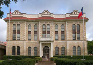
Robertson County is a county located in the state of Texas. Based on the 2010 census, its population was 16,622. Its county seat is
Franklin. The county was created in 1837 and organized the following year. It is named for Sterling C. Robertson, an early settler who signed
the Texas Declaration of Independence.
Robertson County is part of the College Station-Bryan, TX Metropolitan Statistical Area.
Etymology - Origin of Robertson County Name
Sterling Clack Robertson, a founder of a colony in early Texas
Demographics:
County QuickFacts: CensusBureau Quick Facts
Robertson County History
Robertson County is a county located in the US state of Texas.Its seat is Franklin. The county is named for Sterling C. Robertson, an early settler who signed the Texas Declaration of Independence.
Handbook of Texas Online
On December 14, 1837, the First Texas Congress passed a measure establishing Robertson County from portions of
Milam, Bexar, and Nacogdoches counties and naming it in honor of Sterling Robertson. When the county was organized
the following year, the settlement of Franklin (usually referred to as Old Franklin today to differentiate it from
the present county seat also named Franklin), which served as headquarters for surveyors of a land district
including present Leon, Freestone, Limestone, Navarro, and other counties, became the county seat. Over the next
nine years sixteen counties were carved from its original jurisdiction, and the county only assumed its present
limits in 1846. In 1850 the county residents voted to move the county seat from Old Franklin to Wheelock because the
town was closer to the most heavily populated areas of the area. Six years later the county seat was once again
moved, this time to a new town, Owensville, near the geographical center of the county, where it remained until
after the Civil War. During the mid-1830s Robertson County was the scene of
numerous battles between Anglo-American settlers and Indians. Among the most famous was the May 19, 1836, attack on
Fort Parker during which Cynthia Ann Parker, mother of Chief Quanah Parker,
was taken captive. The Indian raids, however, began to abate after 1838, when a company of Texas Rangers
commanded by Eli Chandler was stationed at Old Franklin. By the time Texas
joined the United States in 1846, the frontier had pushed farther west, and Indian raids in Robertson County had
become infrequent More at
James L. Hailey and Christopher Long, "ROBERTSON COUNTY," Handbook of Texas Online (http://www.tshaonline.org/handbook/online/articles/hcr09),
accessed January 24, 2016. Uploaded on June 15, 2010. Modified on November 24, 2015. Published by the Texas State Historical Association.
Geography: Land and Water
As reported by the Census Bureau, the county has a total area of 866 square miles (2,242 km2), of which, 855
square miles (2,213 km2) of it is land and 11 square miles (29 km2) of it (1.28%) is water.
Neighboring Counties
Bordering counties are as follows:
- Limestone County (north)
- Leon County (northeast)
- Brazos County (southeast)
- Burleson County (south)
- Milam County (southwest)
- Falls County (northwest)
Education


Click Image to Enlarge
