


Click Image to Enlarge
Texas Counties
Texas is divided into two hundred and fifty-four counties, more than any other state. Texas was originally divided into municipalities, a unit of local government under Spanish and Mexican rule. When the Republic of Texas gained its independence in 1836, there were 23 municipalities, which became the original Texas counties. Many of these would later be divided into new counties. The most recent county to be created was Kenedy County in 1921. The most recent county to be organized was Loving County in 1931San Saba County, Texas
San Saba County Education, Geography, and History
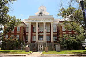
San Saba County is a county located on the Edwards Plateau in western Central Texas. Based on the 2010 census, its population was 6,131. Its county seat is San Saba. The county is named for the San Saba River, which flows through the county.
Etymology - Origin of San Saba County Name
The county is named for the San Saba River, which flows through the county.
Demographics:
County QuickFacts: CensusBureau Quick Facts
San Saba County History
San Saba County is a county located in the US state of Texas. Its county seat is San Saba
Handbook of Texas Online
Archeological evidence indicates that Tonkawas, Apaches, Caddoans, and Comanches inhabited the area at different
times. Comanches and Lipan Apaches continued to live in the San Saba County area into the eighteenth and nineteenth
centuries, often coming into conflict with Spanish missionaries, United States military forces, and Anglo-American
settlers. The first European exploration of the area occurred in 1732, when an expedition led by the Spanish
governor of Texas, Juan Antonio Bustillo y Ceballos, passed through the
vicinity. Jos?Mares is also supposed to have crossed the area in 1788 on an
expedition from San Antonio to Santa Fe. The original surveys of present San Saba County indicate that the first
land grants, of a league each along the San Saba River, were given to Spanish grantees. The earliest known record of
Anglo-Americans in San Saba County was in December 1828, when a group of twenty-eight citizens from Austin's colony
at Gonzales traveled through the eastern area of the county on their way to recapture a band of horses. A part of
the county was included in one of the grants ceded to Stephen F. Austin under
the Mexican empresario system. The Beall grant, which overlapped the Austin
grant, was another. In the case of these early grants individuals took legal but not physical possession of the
land. The Fisher-Miller land grant, ceded by the Republic of Texas
in 1842, can also be included in this category. Most of the later land deeds for San Saba County were out of the
Fisher-Miller surveys, but the original members of this group of German-Texan pioneers did not stay in the area.
Early permanent settlers included the Harkey family, who settled at Wallace and Richmond creeks in the fall of 1854,
and the David Matsler family, who moved from Burnet County and settled on Cherokee Creek that same year. San Saba
County was organized in 1856 from Bexar County and was named for the San Saba River. The act establishing the county
was passed by the Sixth Legislature and approved on February 1, 1856. The first election was held on May 3 to select
county officers and a county seat. The results of this election were set aside because of irregularities, and
another election was ordered. On July 19 the present site of the town of San Saba was selected for the county seat.
Chappel, settled during the 1850s, was San Saba County's first town. Other towns founded at this time included
Richland Springs, Sloan, Deer Creek, Colony, Harkeyville, and San Saba. Cherokee, Harmony Ridge, Holt, and Bend
developed over the next twenty years. The original boundaries of the county were confirmed by the Seventh
Legislature in 1858. During the Civil War the citizens of San Saba County
supported the Confederacy. Although they held relatively few slaves, they favored states' rights. The majority of
San Sabans who served in the Confederate forces were in the regiment of Col. James E. McCord.
Their primary assignment was to protect the frontier, and they used Camp San Saba, a ranger station in McCulloch
County, as their base of operations. More at
Victoria S. Murphy, "SAN SABA COUNTY," Handbook of Texas Online (http://www.tshaonline.org/handbook/online/articles/hcs05),
accessed January 24, 2016. Uploaded on June 15, 2010. Published by the Texas State Historical Association.
Geography: Land and Water
As reported by the Census Bureau, the county has a total area of 1,138 square miles (2,948 km2), of which,
1,134 square miles (2,938 km2) of it is land and 4 square miles (10 km2) of it (0.33%) is water.
Neighboring Counties
Bordering counties are as follows:
- Mills County (north)
- Lampasas County (east)
- Burnet County (southeast)
- Llano County (south)
- Mason County (southwest)
- McCulloch County (west)
- Brown County (northwest)
Cities and Towns:
Education

County Resources:
Enter County Resources and Information Here

Click Image to Enlarge
