


Click Image to Enlarge
Texas Counties
Texas is divided into two hundred and fifty-four counties, more than any other state. Texas was originally divided into municipalities, a unit of local government under Spanish and Mexican rule. When the Republic of Texas gained its independence in 1836, there were 23 municipalities, which became the original Texas counties. Many of these would later be divided into new counties. The most recent county to be created was Kenedy County in 1921. The most recent county to be organized was Loving County in 1931Sutton County, Texas
Sutton County Education, Geography, and History
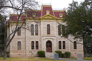
Sutton County is a county located on the Edwards Plateau in the state of Texas. Based on the 2010 census, the population was 4,128. Its county seat is Sonora. The county was created in 1887 and organized in 1890. Sutton County is named for John S. Sutton, an officer in the Confederate Army.
Etymology - Origin of Sutton County Name
John Schuyler Sutton, a Texas Ranger and soldier in the Texas Revolution and Mexican-American War as well as a Confederate officer in the Civil War
Demographics:
County QuickFacts: CensusBureau Quick Facts
Sutton County History
Sutton County is a county located in the US state of Texas.Its county seat is Sonora. Sutton County is named for John S. Sutton, an officer in the Confederate Army.
Handbook of Texas Online
Anglo-Americans began moving into the area in the early 1870s. Initially attracted by the availability of water
in various places along the Devils River, ranchers were soon drawn by the rich, unoccupied pastureland of the
western Edwards Plateau. So successful were the herds that grazed in Sutton County, then a part of Crockett County,
that by 1878 the region was known as Cattleman's Paradise, a nickname that was soon changed to Stockman's Paradise,
since both sheep and cattle ranching were important. With the tremendous growth of the cattle industry in the late
1870s and early 1880s, the available rangeland across Texas was occupied quickly and in time fenced off into
ranches. This trend was reflected in Sutton County but was slowed by the lack of accessible water. In 1882 a
traveler reported that the Birtrong Ranch, which depended on Wall's Well, a seep discovered by Tom Birtrong and Ed
Wall in 1881, was the area's only ranch. By 1885 there were eleven, all but one located near the region's few
sources of groundwater. That one exception was the ranch of A. J. Winkler, who in 1884 had drilled a well,
successfully tapping the water table. Henceforth, ranching on the Edwards Plateau was closely tied to well water,
its extraction made easier by the development of the wind-powered water pump and the horse-powered drill. Increasing
numbers of ranchers moved to the area and, in order to protect their water supplies as well as their range grass
from roaming herds, began to fence off their holdings. By 1898, scarcely ten years after the erection of the first
fence, almost all of the area's 120 ranches were fenced. The discovery of a reliable water supply also stimulated
settlement. The area around Winkler's Well became a small frontier town, which by 1887 had twenty families and a
number of buildings, including a Masonic lodge that doubled as a schoolhouse. At about the same time Charles G.
Adams, a merchant and sometime rancher from Fort McKavett, moved to the area and settled two miles north of
Winkler's Well. Adams seems to have moved into the area with the intention of founding a town and perhaps profiting
from land sales. Initially, his plan seemed doomed to failure, since the site, which he named Sonora, had an
insufficient water supply to attract many settlers. In 1887 the Texas legislature established Sutton County, which
was carved out of eastern Crockett County and named after Confederate officer John S. Sutton.
The establishment of Sutton County set off a new round of competition between the interests at Winkler's Well, now
called Wentworth, and Sonora, over the location of the county seat. Initially Wentworth had the advantage, but in
1889 Charles Adams was successful in drilling a well on the Sonora courthouse property. With its water supply
assured, Sonora proceeded to entice settlers with land grants. This program proved decisive, for by the time of the
1890 election Sonora had a large enough population to assure that it, not Wentworth, would be the county seat. By
1900 Wentworth had ceased to exist. More at
Brian C. Hosmer, "SUTTON COUNTY," Handbook of Texas Online (http://www.tshaonline.org/handbook/online/articles/hcs17),
accessed January 24, 2016. Uploaded on June 15, 2010. Published by the Texas State Historical Association.
Geography: Land and Water
As reported by the Census Bureau, the county has a total area of 1,454 square miles (3,767 km2), of which,
1,453 square miles (3,765 km2) of it is land and 1 square miles (2 km2) of it (0.04%) is water.
Neighboring Counties
Bordering counties are as follows:
- Schleicher County (north)
- Kimble County (east)
- Edwards County (south)
- Val Verde County (southwest)
- Crockett County (west)
Education
Sutton County is served by the Sonora Independent School District based in Sonora.


Click Image to Enlarge
