


Click Image to Enlarge
Texas Counties
Texas is divided into two hundred and fifty-four counties, more than any other state. Texas was originally divided into municipalities, a unit of local government under Spanish and Mexican rule. When the Republic of Texas gained its independence in 1836, there were 23 municipalities, which became the original Texas counties. Many of these would later be divided into new counties. The most recent county to be created was Kenedy County in 1921. The most recent county to be organized was Loving County in 1931Tarrant County, Texas
Tarrant County Education, Geography, and History
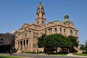
Tarrant County is a county located in the state of Texas. Based on the 2010 census, it had a population of 1,809,034. It is the third-most
populous county in Texas and the sixteenth-most populous in the United States. Its county seat is Fort Worth.
Tarrant County, one of 26 counties created out of the Peters Colony, was established in 1849 and organized the next year. The county was named
in honor of General Edward H. Tarrant of the Republic of Texas militia.
Tarrant County is part of the Dallas-Fort Worth-Arlington, TX Metropolitan Statistical Area.
Etymology - Origin of Tarrant County Name
Edward H. Tarrant, who drove the Native Americans out of the future county, opening it up for settlement (his middle initial may stand for "Hampton")
Demographics:
County QuickFacts: CensusBureau Quick Facts
Tarrant County History
Tarrant County is a county located in the US state of Texas. Its county seat is Fort Worth.
Handbook of Texas Online
During the decade of the 1850s the population of Tarrant County rose dramatically. The 1850 census showed 599
whites and sixty-five slaves. By 1860 the number of whites had grown to 5,170, and the number of slaves had
increased to 850. Even though Fort Worth was abandoned as a military outpost in 1853, the settlers who had made
their homes near the fort remained. Old fort buildings were turned into a hotel, a general store, and a doctor's
office. In the western part of the county White Settlement was formed by people from Tennessee. In the southeast
settlers of predominantly Scotch-Irish background founded Gipson. The fastest growing area was in the northeast,
near Grapevine Prairie. When Tarrant County was organized, Birdville was designated the county seat. That decision
was soon questioned by influential citizens of Fort Worth such as Middleton Tate Johnson, who lobbied vigorously to
have Fort Worth made the county seat. These efforts resulted in a special election in 1856 in which Fort Worth won
by a narrow margin. The election and the tactics employed by both towns caused much ill will. Several acts of
violence followed the election, and the results were declared invalid. When another election was scheduled for April
1860, Fort Worth aided its cause by promising to build a permanent courthouse. The election results showed Fort
Worth the clear winner, and the issue was finally settled. The 1860s brought the effects of Civil War and
Reconstruction to Tarrant County. That decade was the only one in which the
county population declined, from 6,020 to 5,788. The number of slaves in the county was relatively small, and
opinions concerning secession were varied. Many of the county's settlers had
spent some time in free states before arriving in Texas. The vote on secession favored disunion, but only by a
margin of twenty-seven out of a total of 800 ballots. Tensions in the divided community led to the lynching of two
suspected abolitionists, William H. Crawford and Anthony Bewley, in Fort Worth.
With the advent of war came economic decline and shortages. The price of flour rose to fifteen dollars for 100
pounds, and calico was four dollars per yard. Other scarce items were coffee, sugar, and salt. Construction on the
proposed courthouse came to a halt. During Reconstruction the county government elected in 1866 was removed in 1867,
and men whom the federal government considered loyal to the United States were appointed. A federal military force
occupied Fort Worth under this government, which functioned until 1869, when new elections were held More at
W. Kellon Hightower, "TARRANT COUNTY," Handbook of Texas Online (http://www.tshaonline.org/handbook/online/articles/hct01),
accessed January 24, 2016. Uploaded on June 15, 2010. Published by the Texas State Historical Association.
Geography: Land and Water
As reported by the Census Bureau, the county has a total area of 897 square miles (2,324 km2), of which, 863
square miles (2,236 km2) of it is land and 34 square miles (88 km2) of it (3.80%) is water.
Neighboring Counties
Bordering counties are as follows:
- Denton County (north)
- Dallas County (east)
- Ellis County (southeast)
- Johnson County (south)
- Parker County (west)
- Wise County (northwest)
Education


Click Image to Enlarge
