


Click Image to Enlarge
Texas Counties
Texas is divided into two hundred and fifty-four counties, more than any other state. Texas was originally divided into municipalities, a unit of local government under Spanish and Mexican rule. When the Republic of Texas gained its independence in 1836, there were 23 municipalities, which became the original Texas counties. Many of these would later be divided into new counties. The most recent county to be created was Kenedy County in 1921. The most recent county to be organized was Loving County in 1931Wilson County, Texas
Wilson County Education, Geography, and History
Wilson County is a county located in the state of Texas. Based on the 2010 census, its population was 42,918. Its county seat is
Floresville. The county is named after James Charles Wilson.
Wilson County is part of the San Antonio-New Braunfels, TX Metropolitan Statistical Area.
Etymology - Origin of Wilson County Name
James Charles Wilson, a Texas state senator, member of the ill-fated Somervell Expedition into Mexico, and Methodist minister
Demographics:
County QuickFacts: CensusBureau Quick Facts
Wilson County History
Archeological evidence in the Wilson County area reveals early habitation from the Paleo-Indians Hunter-gatherers
period. Later, the area was a hunting range for Tonkawa, Aranamas, Tamiques, Karankawa. Tawakoni, Lipan Apache and Comanche lived and hunted
in the county.
In September 1718 Martín de Alarcon crossed the area on his way to explore the bay of Espiritu Santo. Pedro de Rivera y Villalon crossed the
county in 1727 as part of an expedition to inspect the frontier defenses of New Spain. In 1766-67 the Marques de Rubí included the area in his
inspection of the Spanish frontier, and the 1798 explorations of the coast by Francisco Vasquez de Coronado skirted the area.
The first two land grants in the area were to Luis Menchaca and Andrés Hernández, who established ranches circa 1832-1833.
Anglos began arriving in the 1840s, and Southern planters in 1850 and 1860, followed by German and Polish immigrants from other counties.
Wilson County was formed in 1860 from Bexar and Karnes. Sutherland Springs was designated the county seat. Its county seat is Floresville. The county is named
after James Charles Wilson.
Handbook of Texas Online
The first Anglo settlers arrived in the region in the late 1840s, settling along the Ecleto and Cibolo creeks.
Between 1850 and 1860 planters from the Southern states moved into the area, as did German immigrants from Guadalupe
County and Polish immigrants from Karnes County. Wilson County was established by an act of the legislature on
February 13, 1860. It was cut from Bexar and Karnes counties and named for Somervell expedition
member and legislator, James C. Wilson. Sutherland Springs was designated the
county seat, and Dr. G. J. Houston, one of the first residents of La Vernia, was appointed as commissioner to
organize the new county. William Sutherland became chief justice, S. W. Barker was sheriff, and John Irwin's
storehouse became a temporary courthouse. By the eve of the Civil War Wilson
County had a population of 1,500. Because of the emphasis on cattle-raising rather than a plantation economy, the
number of slaves remained small; in 1860 there were only a few hundred slaves in the county. Nevertheless, Wilson
County residents voted for secession and most actively supported the Confederate
cause. Several companies of militia were organized. A protracted period of drought lasting from 1862 to 1865 further
compounded wartime hardships. Because of the relatively small number of slaves, however, abolition did not affect
the fortunes of Wilson County residents as severely as it did in other counties, and the economy rebounded more
quickly than in many other parts of the state. In the years after the Civil War, Wilson County experienced a period
of flux. John W. Longsworth, appointed judge and county clerk by the military government during congressional
Reconstruction, moved the county records to Lodi in 1867, beginning a
controversy about the location of the county seat that lasted for more than a decade. The county seat was returned
to Sutherland Springs in March 1871 but moved back to Lodi in July 1871. An election was finally held in November
1873 to determine the location of county government, and the new town of Floresville, near the geographic center of
the county, was selected as the new county seat. The citizens of Sutherland Springs called for a new election in
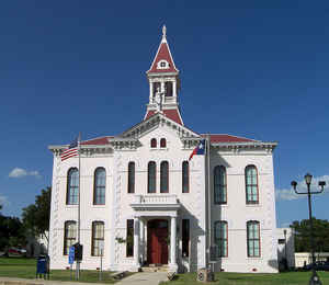
1883, but Floresville once again won by a margin of 250. The courthouse at Floresville was destroyed by fire in
1883, but the records were saved. The same year officials appointed noted San Antonio architect Alfred Giles
to design a new courthouse in Floresville. More at
Christopher Long, "WILSON COUNTY," Handbook of Texas Online (http://www.tshaonline.org/handbook/online/articles/hcw12),
accessed January 24, 2016. Uploaded on June 15, 2010. Published by the Texas State Historical Association.
Geography: Land and Water
As reported by the Census Bureau, the county has a total area of 809 square miles (2,094 km2), of which, 807
square miles (2,090 km2) of it is land and 2 square miles (4 km2) of it (0.20%) is water.
Neighboring Counties
Bordering counties are as follows:
- Guadalupe County (north)
- Gonzales County (northeast)
- Karnes County (southeast)
- Atascosa County (southwest)
- Bexar County (northwest)
Education


Click Image to Enlarge
