


Click Image to Enlarge
West Virginia Counties
There are fifty-five counties in the state of West Virginia. Fifty of them existed at the time of the Wheeling Convention in 1861, before which West Virginia was part of the state of Virginia. The remaining five (Grant, Mineral, Lincoln, Summers and Mingo) were formed within the state after its admission to the United States on June 20, 1863. At that time, Berkeley County and Jefferson County, the two easternmost counties of West Virginia, refused to recognize their inclusion in the state. In March 1866, the US Congress passed a joint mandate assenting to their inclusion.Fayette County, West Virginia
Fayette County Education, Geography, and History
Fayette County is a county located in the state of West Virginia. Based on the 2010 census, the population was 46,039. Its county seat is
Fayetteville.
Fayette County is a part of the Beckley, WV Metropolitan Statistical Area.
Etymology - Origin of Fayette County Name
In honor of the Marquis de Lafayette
Demographics:
County QuickFacts: CensusBureau Quick Facts
Early History of Fayette County, West Virginia
Fayette County was created by an act of the Virginia General Assembly in 1831 from parts of Greenbrier, Kanawha, Logan and Nicholas counties. It was named in honor of the Marquis (Gilbert Motier) de LaFayette (1757-1834), French military hero and American ally during the American Revolutionary War.
An expedition led by Captain Thomas Batts, Thomas Wood and Robert Fallam were the first Englishman to reach the present site of Fayette County. They reached the Kanawha Falls on the afternoon of September 16, 1671. Walter Kelly was the first English settler in the county, arriving in 1773. Soon afterwards, he was killed by Indians for trespassing on their hunting grounds. The following year, William Morris, Sr. became the first permanent English settler in the county, building a cabin at Cedar Grove at the mouth of Kelly's Creek in 1774.
The next group of settlers arrived around 1790 on the present site of Ansted. These were a group of "squatters" who lacked legal title to the land. Among them were the families of James Lykens, William Parrish, James Taylor, and Bailey Woods.
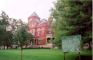
The first county court was held in 1831 at the Miles Manser general store which stood near Ansted, named for the British geologist David T. Ansted who owned the land on which the town was located. It served as the county seat until 1837 when the county's residents voted to make Fayetteville the permanent county seat.
Fayetteville was settled by Abraham Vandal in 1818 and was originally called Vandalia. When Vandal platted the land in 1836 he named the city in honor of the Marquis de LaFayette. The town was incorporated in 1883. The original county court house was constructed in 1838 after the town approved a tax levy of $1,500 for its construction "near the dead chestnut tree in Vandal's rye field." The use of indirect firing, now in universal use in militaries across the globe was first used in Fayetteville during the Civil War. From: West Virginia Heritage Encyclopedia, compiled by Hardesty.
Geography: Land and Water
As reported by the Census Bureau, the county has a total area of 668 square miles (1,730 km2), of which 662 square miles
(1,710 km2) is land and 6.8 square miles (18 km2) (1.0%) is water.
Plum Orchard Lake, a reservoir southwest of Oak Hill, is the second largest lake in West Virginia.
Neighboring Counties
Bordering counties are as follows:
- East: Greenbrier County
- North: Clay County
- Northeast: Nicholas County
- Northwest: Kanawha County
- Southeast: Summers County
- Southwest: Raleigh County
Education


Click Image to Enlarge
