


Click Image to Enlarge
West Virginia Counties
There are fifty-five counties in the state of West Virginia. Fifty of them existed at the time of the Wheeling Convention in 1861, before which West Virginia was part of the state of Virginia. The remaining five (Grant, Mineral, Lincoln, Summers and Mingo) were formed within the state after its admission to the United States on June 20, 1863. At that time, Berkeley County and Jefferson County, the two easternmost counties of West Virginia, refused to recognize their inclusion in the state. In March 1866, the US Congress passed a joint mandate assenting to their inclusion.Hardy County, West Virginia
Hardy County Education, Geography, and History
Hardy County is a county located in the state of West Virginia. Based on the 2010 census, the population was 14,025. Its county seat is Moorefield. The county was created from Hampshire County in 1786 and named for Samuel Hardy, a distinguished Virginian.
Etymology - Origin of Hardy County Name
For Samuel Hardy, a distinguished Virginian
Demographics:
County QuickFacts: CensusBureau Quick Facts
Hardy County History
The first European known to visit this area was John Van Meter in 1725. The earliest permanent European settlements
were established in the 1730s.
Hardy County was formed in 1786 from Hampshire County in Virginia. When West Virginia was admitted to the Union in 1863 it followed.
Early History of Hardy County, West Virginia
Hardy County was created from Hampshire County in 1786, and named for Samuel Hardy, a distinguished Virginian. The first entry in the Hardy
County Court record book states that the Court met on February 7, 1786, at the house of William Bullitt. At a Court held at the same house on
March 7, 1786, it was ordered that the Sheriff let the Court House at the next April Court to the lowest bidder. It was to be built of logs
with diamond corners and to be hewn down inside and outside and measure 26 ft. by 22 ft. It was to have a story and one half with a stone or
brick chimney.
The second court house was built on the corner of Winchester and Franklin Streets (now South Elm Street) in 1792-93 by Abel Seymour, added to
in 1833 and used as the Court House until 1860 and has since housed offices, apartments, and a day and boarding school for girls. The building
still stands and currently is used for apartments.
The third Court House was built in 1859-60 on South Main Street. Plans housed in the Clerk's office show the arranger (designer) as Col. Jno.
B. Baldwin and the plans were drawn by Wm. A. Pratt. William Eberly from Moorefield was the builder. The building is still standing although
greatly altered in appearance. After 1914 store fronts were added to the structure and since then it has been used by various retail
establishments and as an apartment house.
During the fractious period of the Civil War the Court met irregularly and at least once outside the Court House. The meeting was at the house
of John Mathias on Lost River on May 2, 1864. This log house is standing and has been partially restored.
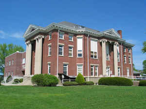
The present Court House was built during 1911-1914 on the corner of Washington and Elm Streets. The architects were Millburn, Heister and Co.
of Washington, DC. It was declared to be the official home of the Court beginning August 24, 1914. In 1985, the building was extensively
renovated inside and an addition constructed on the north side. The architect for the addition was Grandee, Thomas & Sprouse of Charleston,
WV. Except for the north side, the facade of the original building remains nearly unchanged from its original design. In today's society where
the display of the Ten Commandments in Court Houses is hotly debated it is interesting to note that between Feburary 6, 1920, and March 12,
1922, the Methodists held Sunday services in the Court House while their new church was under construction.
Compiled July 2005 by Eleanor L. Heishman
Geography: Land and Water
As reported by the Census Bureau, the county has a total area of 584 square miles (1,510 km2), of which 582 square miles
(1,510 km2) is land and 2.2 square miles (5.7 km2) (0.4%) is water.
Through this county flows the South Branch Potomac River with its surrounding magnificent valley. Several miles wide, "the Valley," as it is
commonly called, contains lands whose fertility lends itself to successful farming. Agriculture and stock raising have always been the main
source of employment in this area, with corn, wheat, apples, peaches, melons, cattle and poultry having important interests. Truck-farming has
a vital role, each household possessing its own small garden.
On either side of the Valley are high mountains with rough terrain and heavy timber. Throughout the area wildlife is plentiful, and hunting
has always been a major diversion and source of meat supply. In the winter snows are whipped by winds of gale force, and snowdrifts are
usually numerous.
The South Branch is a clear stream, quite wide, and of considerable depth in many places. Watering the Valley, the river abounds in fish and
creates many picturesque settings. At times the usually calm waters surge from low banks and spread over the Valley, enveloping and ravishing
the rich surrounding lands. The river has a peculiar feature in the field of geology as it flows through the Valley. At one point the river,
thousands of years ago, did not cut across the mountains from one side to the other, but made a passage through them from end to end. This
geological exception is now in the form of a narrow, trough-like gap, about seven miles (11 km) long, and appropriately called "The Trough".
At the present day, the gorge is several hundred feet deep, and the South Branch flows in a narrow channel at the bottom, with almost
perpendicular walls of rock on either side.
In the very center of the South Branch Valley, surrounded by high mountains, and located on the east side of the junction of the South Fork
South Branch Potomac River and the South Branch Potomac, is Moorefield, the county seat of Hardy County. A quiet farming center in 1860, the
population of the Moorefield area at that time was about 1,500. At this period there were no bridges at Moorefield, and the South Branch had
to be forded some three miles (5 km) up the Valley, or the ferryboat, which was usually busy, had to be used. The main towns that communicated
with Moorefield were Petersburg, Romney, and New Creek (presently Keyser) the latter having a stage line between the two points.
Neighboring Counties
Bordering counties are as follows:
- North: Mineral County
- Northeast: Hampshire County; Frederick County, Va.
- Northwest: Grant County
- South: Rockingham County, Va.
- Southeast: Shenandoah County, Va.
- Southwest: Pendleton County
Education


Click Image to Enlarge
