


Click Image to Enlarge
West Virginia Counties
There are fifty-five counties in the state of West Virginia. Fifty of them existed at the time of the Wheeling Convention in 1861, before which West Virginia was part of the state of Virginia. The remaining five (Grant, Mineral, Lincoln, Summers and Mingo) were formed within the state after its admission to the United States on June 20, 1863. At that time, Berkeley County and Jefferson County, the two easternmost counties of West Virginia, refused to recognize their inclusion in the state. In March 1866, the US Congress passed a joint mandate assenting to their inclusion.Kanawha County, West Virginia
Kanawha County Education, Geography, and History
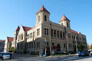
Kanawha County is a county located in the state of West Virginia. Based on the 2010 census, the population was 193,063, making it the most
populous county in West Virginia. Its county seat is Charleston, the state capital.
Kanawha County is included in the Charleston, West Virginia Metropolitan Statistical Area.
Etymology - Origin of Kanawha County Name
For the Great Kanawha River, which itself was named after the Indian tribe which once resided there
Demographics:
County QuickFacts: CensusBureau Quick Facts
Early History of Kanawha County
The formation of Kanawha County was authorized by the Virginia General Assembly on November 14, 1788 from parts of Greenbrier and Montgomery counties. It was actually formed on October 5, 1789. According to the national census of 1800, Kanawha County had 3,239 residents, the 11th largest population of the 13 counties then in existence within the present state of West Virginia. Berkeley County had the largest population then (22,006) and Wood County had the smallest population (1,217).
Kanawha County was named in honor of the Great Kanawha River that runs through the county. The River was named for the Indian tribe that once lived in the area. The spelling of the Indian tribe varied at the time from Conoys to Conois to Kanawha. The latter spelling was used and has gained acceptance over time.
Simon Kenton and two companions whose names were not recorded built a cabin at the mouth of the Elk River in 1771, making them the first Englishmen to call present day Kanawha County their home. A roving band of Indians discovered them, and considering them trespassers on their hunting grounds, attacked them. One of Kenton's companions was killed in the attack. After making their escape, Simon Kenton and his remaining companion decided to leave the county for good.
In 1773, Colonel Thomas Bullitt and several others explored the Kanawha Valley to survey the land in anticipation of being granted large tracts of the land in return for their military service.
In 1774, Walter Kelly, of North Carolina, attempted the first, permanent settlement in the county. He built a cabin along a stream, known as Kelly's Creek, about 20 miles north of the current location of Charleston. He was killed by Indians later that year.
It is likely that Mary Ingles and Betty Draper were the first English women to pass through present day Kanawha County. They were captured by Indians at Drapper Meadows, Virginia (now Blacksburg) on July 8, 1755 and taken by the Indians through the county as they made their way to Shawnee Village at Chillicothe, Ohio. Mary Ingles' escape four months later and her return through the wilderness to Virginia was an inspiration to all pioneers on the frontier.
The land where Charleston, the county seat and currently the state's most populous city and its state capitol, was founded was originally owned by Colonel Thomas Bullitt. In 1774, he was deeded 1,240 acres of land on the Great Kanawha River by the mouth of the Elk River for his service during the French and Indian Wars (1754-1763). He sold the land to his brother, Judge Cuthbert Bullitt, President of the Virginia Court of Appeals who, in turn, sold the land in 1786 to Colonel George Clendenin, a distinguished frontiersmen and soldier in General Lewis' army at the decisive Battle of Point Pleasant (1774). It is said that the land on which Charleston currently stands was sold for 84 cents. Colonel Clendenin, his father Charles, his brothers and sister, and six other families moved to the mouth of Elk River, at the present site of Charleston in 1788 and built the first building within the boundaries of what is now the state capitol. The two-story, double log building was known as being both bullet and arrow proof and was known as Clendenin's Fort. The first meeting of the county court took place there on October 5, 1789. The town was chartered by the Virginia Assembly on December 19, 1794 and named Charles Town, in honor of Charles Clendenin. The town's name was shortened to Charleston to avoid confusion with two other towns in present day West Virginia that were also called Charles Town.
The state capitol was moved from Wheeling to Charleston on April 1, 1870, but a national depression that started in 1873 caused the city's economy to stagnate and, as its economy faltered, a movement began to return the state capitol to Wheeling because its economy had not suffered quite as much as Charleston's. In 1875, the state's voters returned the state capitol to Wheeling. Once the depression ended, the Kanawha Valley's economy began to grow and as its population grew a movement began to regain the honor of being the state capitol. Another statewide referendum was held in 1885 and Charleston won back the honor of being the state's capitol.
Daniel Boone (1734-1820), the famous frontiersmen and founder of Kentucky, resided with his family in Kanawha County for seven years (1788-1795), in a two-room log cabin in the Kanawha City section of Charleston. He was appointed a Lieutenant Colonel in the Kanawha County militia and served under the command of Colonel George Clendenin. He and Colonel Clendenin represented Kanawha County in the General Assembly in 1791 (see Boone County history).
Geography: Land and Water
As reported by the Census Bureau, the county has a total area of 911 square miles (2,360 km2), of which 902 square miles
(2,340 km2) is land and 9.3 square miles (24 km2) (1.0%) is water.
It is the fourth-largest county in West Virginia by area.
Neighboring Counties
Bordering counties are as follows:
- North: Jackson County
- Northeast: Roane County; Clay County
- Northwest: Putnam County
- Southeast: Fayette County; Raleigh County
- Southwest: Boone County; Lincoln County
Education


Click Image to Enlarge
