


Click Image to Enlarge
West Virginia Counties
There are fifty-five counties in the state of West Virginia. Fifty of them existed at the time of the Wheeling Convention in 1861, before which West Virginia was part of the state of Virginia. The remaining five (Grant, Mineral, Lincoln, Summers and Mingo) were formed within the state after its admission to the United States on June 20, 1863. At that time, Berkeley County and Jefferson County, the two easternmost counties of West Virginia, refused to recognize their inclusion in the state. In March 1866, the US Congress passed a joint mandate assenting to their inclusion.Wayne County, West Virginia
Wayne County Education, Geography, and History
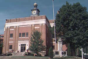
Wayne County is the westernmost county in the state of West Virginia. Based on the 2010 census, the population was 42,481. Its county seat
is Wayne. The county was founded in 1842 and named for General "Mad" Anthony Wayne.
Wayne County is part of the Huntington-Ashland, WV-KY-OH Metropolitan Statistical Area, which is also included in the
Charleston-Huntington-Ashland, WV-OH-KY Combined Statistical Area.
Etymology - Origin of Wayne County Name
In honor of General Anthony Wayne, Revolutionary War hero
Demographics:
County QuickFacts: CensusBureau Quick Facts
Early History of Wayne County, West Virginia
Wayne County was created by an act of the Virginia General Assembly on January 18, 1842 from parts of Cabell County. The county was named in honor of General "Mad" Anthony Wayne (1745-1796).
Anthony Wayne was born on January 1, 1745 in Eastown, Chester County, Pennsylvania. He was educated in Philadelphia and operated a surveyor's office in Eastown. He was sent to Nova Scotia in 1765 to locate a grant of land given to a company of Pennsylvanians and was the superintendent of the settlement for two years. He then returned to Eastown and his surveyor's office. He was appointed a representative to the Pennsylvania General Assembly in 1773 and left that position in 1775 when he was commissioned a Colonel in the Continental Army. Following a series of brilliant military maneuvers during the American Revolutionary War at the Battles of Ticonderoga, Morristown and Brandywine, he was promoted to Brigadier General and given the title of "Mad" Anthony Wayne. He later captured an important British garrison at Stony Point on the Hudson River. In 1783, he retired from the military with the rank of brevet major general. He later served in the Pennsylvania convention that ratified the US Constitution. He then relocated to a farm granted to him by the state of Georgia for his service in that state during the war. He was elected to the US House of Representatives from Georgia in 1791. He was called out of military retirement in 1792 by President George Washington to command an American military force that was being organized to put down a major Indian uprising on the western frontier (along the Ohio River). His command of about 3,000 men engaged and defeated a force of about 2,000 Indians at the Battle of Fallen Timbers on August 20, 1794 near the present site of Toledo, Ohio. The decisive battle led to the end of the Indian uprising. On August 3, 1795, twelve Indian chiefs signed articles of agreement "to bury the hatchet forever" and the treaty, known as "Wayne's Treaty," marked the end of major, organized hostilities with the Indians in what is now West Virginia and along the Ohio River on the western frontier. He died on December 15, 1796.
The county was originally surveyed by George Washington in October 1770 as bounty lands for Captain John Savage and the 60 men in his company for their services during the French and Indian War. Captain Savage's land grant was issued on December 15, 1772 and it included much of present day Wayne County.
The first settler in the county was Samuel Short, who built a cabin in 1796 near the present town of Cassville. Robert Tabor arrived in 1798 and patented a tract of 2,500 acres nearby. Stephen Kelly also arrived in 1798. He built a cabin near Virginia Point.
The first meeting of the county court was held on April 11, 1842 at the home of Abraham Trout. Trout Hill was then established as the county seat, in honor of Abraham Trout, the first settler in the region and the owner of the land on which the town was laid out. A log cabin was constructed to house the court. The town was later incorporated on March 27, 1860 and renamed Fairview. It was often called Wayne Court House by the local residents because the court house was the center of the area's social and economic life. In 1911, the town's name was changed to Wayne to conform with the local custom of referring to the town as Wayne Court House or, if in a hurry, as Wayne.
Geography: Land and Water
As reported by the Census Bureau, the county has a total area of 512 square miles (1,330 km2), of which 506 square miles (1,310 km2) is land and 6.1 square miles (16 km2) (1.2%) is water
Neighboring Counties
Bordering counties are as follows:
- East: Lincoln County
- North: Lawrence County, Ohio
- Northeast: Cabell County
- Northwest: Boyd County, Ky.
- South: Martin County, Ky.
- Southeast: Mingo County
- Southwest: Lawrence County, Ky.
Education


Click Image to Enlarge
