


Click Image to Enlarge
West Virginia Counties
There are fifty-five counties in the state of West Virginia. Fifty of them existed at the time of the Wheeling Convention in 1861, before which West Virginia was part of the state of Virginia. The remaining five (Grant, Mineral, Lincoln, Summers and Mingo) were formed within the state after its admission to the United States on June 20, 1863. At that time, Berkeley County and Jefferson County, the two easternmost counties of West Virginia, refused to recognize their inclusion in the state. In March 1866, the US Congress passed a joint mandate assenting to their inclusion.Wyoming County, West Virginia
Wyoming County Education, Geography, and History
Wyoming County is a county located in the state of West Virginia. Based on the 2010 census, the population was 23,796. Its county seat is Pineville. The county was created in 1850 from Logan County and named for the Delaware Indian word meaning "large plains"
Etymology - Origin of Wyoming County Name
For the Delaware Indian word meaning "large plains"
Demographics:
County QuickFacts: CensusBureau Quick Facts
Early History of Wyoming County, West Virginia
Wyoming County was created by an act of the Virginia General Assembly on January 26, 1850 from parts of Logan County. The county was named for the Wyoming Indian tribe. There is no record of the name's origin. Some historians believe that the name was suggested by its use in a poem written by Thomas Campbell entitled "Gertrude of Wyoming." Others suggest that the county's name came from a loose translation of the Delaware Indian word Maughwauwama, meaning "large or extensive plains."
David Hughes and Edward McDonald were probably the first Englishmen to set foot in present day Wyoming County. They explored the area in 1784. In 1798, John Cook, Sr. explored the present county and discovered a large, level area below present day Oceana. He moved to the county with his wife, Nellie, his four sons, and a daughter-in-law. They built a cabin near the Laurel and Clear Forks in 1799. When they moved to the county they met a man named Milam who had supposedly lived in the area for some time, moving to and from three hunting lodges he had constructed. In 1800, Captain Ralph Stewart and his family settled in the area, just a few miles from the Cook's cabin. In 1802, Edward McDonald, who had explored the area 18 years earlier, moved into the county. He was accompanied by his son-in-law, James Shannon, and several slaves. They started clearing land for a plantation at the main fork of the Guyandotte River. In the meantime, the Cook and Stewart families intermarried, creating a strong bond between the families that lasted for generations. A census taken in 1890 revealed that a majority of the county's residents were direct descendants of John Cook, Sr.
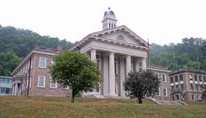
The first meeting of the Wyoming County court was held at John Cook's home, near present day Oceana. The act creating the county specified that the county seat was to be laid out on the lands of William Cook, Sr., one of John Cook's sons. The town was laid out that year and originally named Cassville, in honor of Lewis Cass, a famous American statesman. L. B. Chambers operated the town's first business, a retail store. At that time, the county was only sparsely populated. The 1850 census revealed that there were only 1,645 people living in the county at that time. In 1851, the town was renamed Sumpterville because another settlement was calling itself Cassville, creating confusion for the mails. In 1853, the town's name was changed again, this time to Oceana, in honor of the younger of Chief Cornstalk's daughters. Nevertheless, the town was known by most as Wyoming Court House. Oceana continued to serve as the county seat until 1907 when the county's residents voted to move the location of the county seat to Pineville.
Pineville, the current county seat, was established on the lands of Rev. William H. Cook. It was originally known as Rock View and was incorporated with that name by the West Virginia state legislature on February 16, 1871. The town was renamed Pineville by John W. Cline who reopened a post office there in 1880. He could not use the name Rock View for the post office because it was also used by another town at that time. The name is derived from a large pine forest that existed on the site at that time.
Geography: Land and Water
As reported by the Census Bureau, the county has a total area of 502 square miles (1,300 km2), of which 499
square miles (1,290 km2) is land and 2.4 square miles (6.2 km2) (0.5%) is water.
The county is drained by the branches of Sandy and Guyandotte rivers. The land surface is mountainous
Neighboring Counties
Bordering counties are as follows:
- Northeast: Raleigh County
- Northwest: Mingo County; Logan County; Boone County
- Southeast: Mercer County
- Southwest: McDowell County
Education


Click Image to Enlarge
