


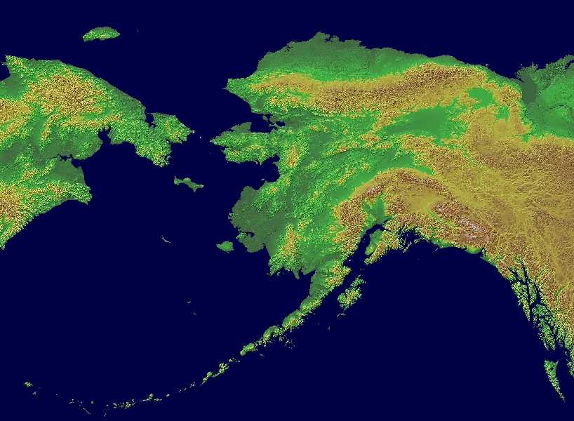
Alaska Geography: The Land
Geography and Landforms of Alaska
Find an overview of Alaska geography, topography, geographic land regions, land areas, and major rivers.
Access Alaska almanac, furnishing more details on the state geography, geographical and land regions, climate and weather, elevation, land areas, bordering states, and other statistical data.
Alaska is by far the largest state in land area.
If you placed it on top of the "lower 48," the Aleutian Islands would touch California's coast, the southeastern coast near Juneau would rest atop
Georgia, and the North Slope would cover Minnesota. The population density of Alaska is only one person per 1.1 square miles.
Alaska's rivers and waterways include the Yukon, third longest in the US. The Yukon stretches East to West from Canada's Yukon Territories to the Bering
Sea. If you travel upriver along many of the rivers in the glacier-formed valleys, you come to large glacier fields. Alaska has more glaciers than
anywhere else in the inhabited world.
Alaska is known for its volcanic activity and related earthquakes. The Pacific Plate of the earth's crust collides and rides under the North American
plate along the Aleutians, causing the Ring of Fire volcanoes. There are more than 70 active or potentially active volcanoes in Alaska. Much research
on volcanoes and geo-physics is conducted in Alaska because of this activity.
Alaska Highest, Lowest, & Mean Elevations |
|
|---|---|
| Mean Elevation | 1,900 ft. |
| Highest Point | Mt. McKinley 20,320 ft |
| Lowest Point | Pacific Ocean Sea level |
Alaska Land Area (Square Miles) |
|
| Geographic Center | The geographic center of Alaska is located approximately 60 miles northwest (NW) of Mt. McKinley Latitude: 63° 50'N Longitude: 152° W |
| Total Area | 663,267.26 sq. mi. 1st |
| Land Area | 571,951.26 sq. mi. 66.24% |
| Water Area | 91,316.00 sq. mi. 13.76% |
| Forested Land Area34.9% | |
| Dimensions (Length - Width) |
1,480 miles - 810 miles |
Alaska Physiographic Regions
The most easily recognizable feature of Alaska's environment is its landforms- mountains, hills, valleys, and rivers. How can we make sense of this complexity? Geographers have used regional concepts to gain perspectives on the landforms. At a very general level, Alaska is part of four general physiographic regions,
- Interior Plains,
- Rocky Mountains,
- Intermontane Basins and Ranges
- Pacific Mountains and Valleys
Arctic Coastal Plain
{Interior Plains}
The northernmost geographic area of Alaska is called the Arctic Coastal Plain. This area lies north of the Rocky Mountain System and slopes gradually toward the Arctic Ocean. This is the land of permafrost (Permanently frozen ground) and no trees can manage to grow in this area. The surface of the ground does thaw enough in the spring to allow the growth of grass and wildflowers however. This area is called the tundra.
Rocky Mountain System of Alaska
{Rocky Mountains System}
North of the Central Uplands and Lowlands area is the Rocky Mountain System of Alaska. This area is comprised of the Brooks Range and the Brooks Range foothills. The Brooks Ranges is comprised of glacier-made mountain peaks that rise to 9,000 feet above sea level in the east with lower elevations in the west.
Central Uplands and Lowlands
{Intermontane Basins and Ranges}
Lying between the two great mountain systems, as its name implies, is the Intermontane Basin and Plateau region. This area is sandwiched between the Alaska Range of the Pacific Mountain System in the south and the Brooks Range of the Rocky Mountain System of Alaska in the north. Its geography makes up the largest land area in Alaska. Bordered on the west by Canada, the Central Uplands and Lowlands region extends westward to include the Seward Peninsula and the Kuskokwim River area of southwestern Alaska. The Central Upland and Lowlands area is marked by low, rolling hills and swampy river valleys such as the those of the Koyukuk, Kuskokwim, Tanana, and Yukon rivers.
This area contains highlands such as the Yukon-Tanana Uplands, the Kuskokwim Mountains, and the Ahklun Mountains. It also contains the largest river systems in Alaska-the Yukon, as well as the vast Yukon-Kuskokwim coastal lowlands that forms the delta region of the two rivers.
{Pacific Mountains and Valleys}
The Pacific Mountain system is divided into many subdivisions and runs from the Aleutian Islands to south central Alaska. It includes the Saint Elias Range, the Wrangell Mountains, the Chugach Mountains, the Talkeetna Mountains, and the Kenai Mountains. Within this region are two major lowland areas, the Copper River Basin and the Susitna-Cook Inlet lowland. The Copper River Basin is located between the Chugach and Wrangell mountains. The Susitna-Cook Inlet is mostly forested and runs north and east from Anchorage.
Alaska Landscape and Landforms:
Major geographical regions (north to south) include the Arctic Coastal Plain, North Slope, Brooks Mountain Range, a central upland dissected by the Yukon River, the massive Alaska Mountain Range, the Pacific Coastal areas and eastern Inside Passage, and the Alaskan Peninsula, and Aleutian Islands of the southwest.
South Central Alaska
South Central Alaska is the southern coastal region and contains most of the state's population. Anchorage and many growing towns, such as Palmer, and Wasilla, lie within this area. Petroleum industrial plants, transportation, tourism, and two military bases form the core of the economy here.
The Alaska Panhandle
The Alaska Panhandle, also known as Southeast Alaska, is home to many of Alaska's larger towns including the state capital Juneau, tidewater glaciers and extensive forests. Tourism, fishing, forestry and state government anchor the economy.
Southwest Alaska
Southwest Alaska is largely coastal, bordered by both the Pacific Ocean and the Bering Sea. It is sparsely populated, and unconnected to the road system, but incredibly important to the fishing industry. Half of all fish caught in the western U.S. come from the Bering Sea, and Bristol Bay has the world's largest sockeye salmon fishery. Southwest Alaska includes Katmai and Lake Clark national parks as well as numerous wildlife refuges. The region comprises western Cook Inlet, Bristol Bay and its watersheds, the Alaska Peninsula and the Aleutian Islands. It is known for wet and stormy weather, tundra landscapes, and large populations of salmon, brown bears, caribou, birds, and marine mammals.
The Alaska Interior
The Alaska Interior is home to Fairbanks. The geography is marked by large braided rivers, such as the Yukon River and the Kuskokwim River, as well as Arctic tundra lands and shorelines.
The Alaskan Bush
The Alaskan Bush is the remote, less crowded part of the state, encompassing 380 native villages and small towns such as Nome, Bethel, Kotzebue and, most famously, Barrow, the northernmost town in the United States.

