


Arizona Geography: The Land
Geography and Landforms of Arizona
Find an overview of Arizona geography, topography, geographic land regions, land areas, and major rivers.
Access Arizona almanac, furnishing more details on the state geography, geographical and land regions, climate and weather, elevation, land areas, bordering states, and other statistical data.
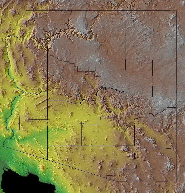
Geographers view Arizona in terms of three major physiographic regions or provinces: the Colorado Plateau, the Central Highlands Transition Zone and the Basin and Range Province. These regions have distinct topography and geologic origins.
The Colorado Plateau in northern and eastern Arizona ranges from 4,000 to 9,000 feet above sea level - its rock formations and deep canyons are known around the world; the Grand Canyon is one of them. The Mogollon Rim forms the edge of the Colorado Plateau in Arizona.
The region below the Rim, called the Central Highlands, is characterized by extensive forests of ponderosa pine and mixed conifers. Unlike the Colorado Plateau to the north, granitic and metamorphic rocks are exposed in many areas. The heat, pressure and water associated with metamorphism caused intense mineralization of nearby rocks, particularly limestone, forming copper minerals. These valuable copper deposits are still being mined in the Clifton-Morenci area and the Globe-Miami area.
The Basin and Range Province includes the south and western portions of the state and is recognized by successive mountain ranges, so called "sky islands"isolated from each other by broad basins. Many sky islands (like the Santa Catalinas, Pinalenos and Huachucas) exceed an elevation of 9,000 feet above sea level.
Arizona Highest, Lowest, & Mean Elevations |
|
|---|---|
| Mean Elevation | 4,100 ft. |
| Highest Point | Humphreys Peak 12,633 ft. |
| Lowest Point | Colorado River 70 ft. |
Arizona Land Area (Square Miles) |
|
| Geographic Center | In Yavapai County, 55 mi. ESE of Prescott Longitude: 111?#8218;° 47.6'W Latitude: 34?#8218;°1 8.5'N |
| Total Area | 113,998.30 sq. mi. 6th |
| Land Area | 113,634.57 sq. mi. 99.69% |
| Water Area | 363.73 sq. mi. 0.31% |
| Forested Land Area | 27.4 percent |
| Dimensions (Length - Width) |
400 miles - 310 miles |
Arizona Physiographic Regions
Arizona consists of three land regions -
(1.) the Colorado Plateau to the north, an arid region of level plains more than 4,000 feet high, the famous Grand Canyon of the Colorado River is located here,
(2.) the Basin and Range Region to the south that made up of mountain ranges and desert basins that run from the northwest to the southeast, and
(3.) the Transition Zone just south of the Colorado Plateau, consisting of a narrow strip of land that is a rugged series of mountain ranges and valleys.
{Colorado Plateau}
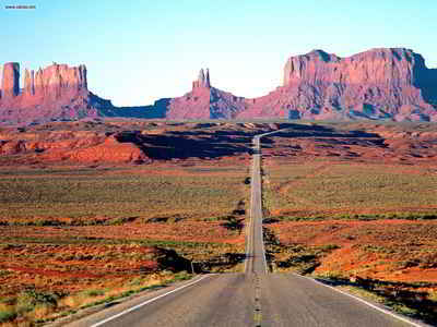
This Plateau is an arid region of level plains more than 4,000 feet high. The highest peak, Humphrey's Peak, is located near Flagstaff is 12,655 feet high. The famous Grand Canyon of the Colorado River is located here. Most of the land is desert-like with little vegetation, but some of the mountains in this region are forested. It is a 2,000-foot high rock wall that extends from the central part of the state to the Mogollon Mountains of southwestern New Mexico. The Colorado Plateau ends with the Mogollon Rim to the south. Black Mesa, one of the largest geological formations in Arizona is found on the Colorado Plateau along with the Painted Desert and the Petrified Forest. Monument Valley is also in this area, a broad valley in the northwest. Monument Valley is beautiful rock formations that rise from its floor, giving the valley its name. It lies along the Utah border. 10,000,000 years of erosion have created a breathtaking landscape.
The Colorado Plateau is centered on the four corners area and extends into Colorado, Utah, Arizona, and New Mexico. It is an area of tablelands with moderate to high relief dissected by narrow and widely-spaced stream valleys. The Colorado Plateau is characterized by limited precipitation, cold winters and hot summers. Lowest elevations are covered with arid shrublands with grass interspersed. Sagebrush is dominant over large areas, with cottonwoods along perennial water courses. At moderate elevations, woodland vegetation is dominated by pinyon pine and juniper, with various shrubs intermixed. Montane forest is in high elevations, with ponderosa pine and Douglas fir dominant to the south and lodgepole pine and aspen farther north.
{Basin and Range Region}
The Basin and Range Region makes up the southern half of Arizona. It is made up of mountain ranges and desert basins that run from the northwest to the southeast. This region is quite rugged and includes the Gila, Mazatzal and Sierra Ancha mountain ranges. This area of the region produces excellent crops with proper irrigation. The Colorado is the most important river in the state. The Colorado forms almost the entire western boundary of Arizona and along with its tributaries drains most of the state. There are several natural lakes in the mountainous areas of Arizona. All of the state's large lakes were made by damming streams for irrigation and water conservation.
{Transition Zone}
The Transition Zone lies just south of the Colorado Plateau and north of the Arizona Basin and Ridge Region. It is a narrow strip of land that is a rugged series of mountain ranges and valleys. The mountain ranges found in this region are, The Mazatzal, Santa Maria, Sierra Ancha, and the White mountain ranges, along with the Salt River Canyon.
Arizona Landscape and Landforms:
Chihuahuan Desert
In the United States, the Chihuahuan Desert includes the Trans-Pecos of Texas, southern New Mexico, and a small area in southeast Arizona. Broad basins and valleys bordered by sloping alluvial fans and terraces make up the dry lowlands of this region, punctuated by occasional mesas and mountain ranges. The Rio Grande and Pecos are the primary rivers of the Chihuahuan Desert. In this arid region, riparian corridors provide important habitat for breeding, in-transit, and wintering birds. Other drainages end in closed basins and include few permanent streams. Arid grass and shrubland are the primary lowland vegetation types, often dominated by creosote. This grades uphill into oak-juniper woodlands and even coniferous forest in the highest reaches. The Madrean mountains mark its western edge, the Edwards Plateau its east, and the reduced shrubbiness of the shortgrass plains its north. The Chihuahuan Desert extends south across much of the Central Plateau of Mexico, bordered by the Sierra Madre Occidental and Oriental.
Mexican Highlands
The isolated mountain ranges of southeastern Arizona and southwestern New Mexico represent the northern terminus of the Sierra Madre Occidental. Elevation determines vegetation, with Douglas fir and pine at higher elevations giving way to oak-dominated forest at lower elevations. Lowlands surrounding the ranges are desert grasslands similar to the Sonoran Desert on the west and Chihuahuan desert on the east.
Mogollon Rim
The Mogollon Rim is primarily in Arizona, extending somewhat into southwest New Mexico. Lower elevations and latitude differentiate this highland
from other mountains to the north and east. Open ponderosa pine forests dominate much of the area, with oak woodlands, pinyon-juniper, and chaparral
at lower elevations.
Mojave Desert
In the "Great American Desert" of the Southwest, the Mohave lies between and is intermediate in nature between the Great Basin to the north and the Sonoran Desert to the south and east. It is mostly in southeast California but extends also into southern Nevada, northwest Arizona, a very small part of southwest Utah, and lies in the rainshadow of the Southern California Ranges to the west. Its most prominent features are broad, sparsely vegetated plains. However, it also includes dry lakes, sharply rising buttes and relatively small mountain ranges, and its eastern portion is cut through by the Colorado River. It is generally a higher elevation desert than the Sonoran, although elevation descends to -300 m in Death Valley. Low precipitation, most falling in winter, with low winter and high summer temperatures are characteristic.
Sonoran Desert
The Sonoran Desert receives a low and unevenly distributed amount of precipitation over extensive plains and isolated mountains surrounding the northern end of the Gulf of California. In the United States it is centered in southwest Arizona and southeast California and extends south through most of Baja California Norte and Sur and the western half of the state of Sonora. Vegetation is sparse and differs from other American deserts by a greater dominance of trees, including arborescent cacti such as the saguaro. Creosote is a common and widely distributed shrub.

