


New York Geography: The Land
Geography and Landforms of New York
 Find an overview of New York geography,
topography, geographic land regions, land areas, and major rivers.
Find an overview of New York geography,
topography, geographic land regions, land areas, and major rivers.
Access New York almanac, furnishing more details on the state geography, geographical and land regions, climate and weather, elevation, land areas, bordering states, and other statistical data.
The geography of New York is diverse. New York is 330 miles long and 283 miles wide. New York covers 54,475 square miles. In size, New York ranks 27th
compared with the other 50 states. Major rivers include the Hudson, the Mohawk and the Genessee. Major lakes include Ontario, Erie, Champlain and George.
New York Highest, Lowest, & Mean Elevations |
|
|---|---|
| Mean Elevation | 1,000 ft. |
| Highest Point | Mt. Marcy 5,344 ft. |
| Lowest Point | Atlantic Ocean Sea level |
New York Land Area (Square Miles) |
|
| Geographic Center | In Madison County, 12 mi. S of Oneida and 26 mi. SW of Utica Longitude: 76° 1.0'W Latitude: 42° 57.9'N |
| Total Area | 54,556.00 sq. mi. 27th |
| Land Area | 47,213.79 sq. mi. 86.55% |
| Water Area | 7,342.22 sq. mi. 13.45% |
| Forested Land Area | 61.5% |
| Dimensions (Length - Width) |
330 miles - 283 miles |
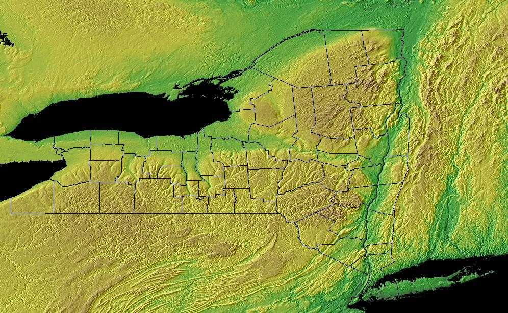
New York: Physiographic Regions
The eastern part of New York state is dominated by the Great Appalachian Valley, while the northern part of the state includes Lake Champlain. This part also features the Hudson River. The western part of the valley features the Adirondack Mountains.
There are 13 Physiographic Provinces located in New York:
- Adirondack Mountains
- Catskill Mountains
- Allegheny Plateau - Glaciated
- Allegheny Plateau - Unglaciated
- Tug Hill Plateau
- Hudson Highlands
- Manhattan Prong
- Taconic Mountains
- Hudson-Mohawk Lowlands
- Mohawk Lowlands
- St. Lawrence - Champlain Lowlands
- Erie and Ontario Lowlands
- Atlantic Coastal Plain
Adirondack Mountain
The Adirondacks are located in the northern part of the state. They are the highest and most rugged mountains. They are located between Lake Champlain in the east and Lake Ontario in the west.
Most of the Adirondacks region consists of an ancient dome of Precambrian rock, similar geologically to the Canadian Shield, but also includes the Tug Hill Upland, which is more similar geologically to the Allegheny Plateau. Landforms include high Appalachian peaks (roughly 90 peaks surpass 1000 m), as well as a broad zone of lower mountains and foothills ranging down to 120 m in elevation. The area is dominated by a combination of maple-beech-birch and red spruce-balsam fir forest, but also includes numerous glacial lakes and bogs, as well as alpine communities. Roughly 2.2 million ha. are covered with forest today, with nearly half of this area consisting of state-owned Forest Preserve and most of the remainder in private industrial timberland. The most pervasive human influence on the natural landscape has been through commercial timber harvest and production, resulting in early removal of dominant white pine, hemlock, and old-growth spruce, and a gradual shift towards greater dominance by northern hardwoods. Although total acreage and volume of the Adirondack forests have increased steadily since 1900, harvest and removal of timber also has increased by nearly 90% since 1968. Harvest today is primarily by means of selective cutting of single trees; therefore age structure and species composition of the forest will continue to be affected without creating additional areas of early seasonal vegetation.
Catskill Mountains
The Catskills rise considerably higher than the neighboring parts of the upland. Summit elevations exceed 2000 ft. and some peaks are over 4000
ft. The mountainous character of the Catskills is due to the action of glaciation and streams carving deep valleys in the flat-lying
rocks.
The eastern boundary of the province is very evident with its high scarp facing the Hudson River
Allegheny Plateau - Glaciated
The glaciated Allegheny Plateau, which includes about one-third of the State, is the most extensive province in the State. On the east, the plateau is separated from the Hudson-Mohawk lowlands by the Helderberg escarpment and, to the south, grades into the Catskill Mountains. A series of escarpments form the boundary between the plateau and the lowlands to the north. The province continues beyond the southern boundary of the State with the exception of the small unglaciated portion of the plateau in the southwest. It is the northeastern part of the great Appalachian Plateau which lies along the western side of the Appalachian Mountains and extends southward into Tennessee. This upland is underlain by great thicknesses of sedimentary rocks which lie almost horizontal, except for a slight dip to the southwest and a kind of sagging in the middle of the Finger Lakes District. Severe dissection by both water and ice erosion has given the upland a somewhat rugged relief. It varies in elevation from 500 to 600 ft. in the north to more than 2,000 ft. in the south. The plateau is thought to represent ancient erosion surfaces and gives a rather flat-topped appearance when viewed from a distance
Allegheny Plateau - Unglaciated
This small segment of the plateau, between the arc of the Allegheny River and the southern border of the State, is a rugged area with steep-sided valleys and high upland areas. Maximum relief is about 1,000 ft. The central mass of the province displays the normal erosion of water-cut features rather than the ice erosion features of the rest of the plateau in New York State. The fringes of the province on the east, north, and west do display features of glaciation and glacial deposition.
Tug Hill Plateau
A wild bleak upland which is truly plateau-like in the "text book" sense. It is an outlier of the Appalachians, entirely separated from this and other provinces. The plateau drops off from flat swampy heights of 1800 ft. - 2000 ft. to the Hudson Mohawk Lowland on the south and to the Erie and Ontario Lowland and the Lower Black River on the west and north. On the east the boundary is a steep scarp face but the steepness disappears on the other side. Relief on the plateau surface is gentle except where easterly-flowing streams have cut "gulf" in the scarp resulting in a series of distinct terraces as it descends 100 ft. (as down a staircase) to the Black River Valley.
Hudson Highlands
This province, extending across the Hudson River in a northeast-southwest direction, covers southern Orange and northern Rockland Counties and the area from southern Dutchess County southward across Putnam County and into Westchester County. It is a rugged, mountainous upland. Maximum relief is about 1,600 ft. where the Hudson River estuary dissects the province (Mt. Beacon, Storm King Mountain, Bear Mountain).
Manhattan Prong
The Piedmont in New York State is a belt of worn-down complex mountains now almost reduced to a plain and lying between the coastal plain and the Highlands. It includes a portion of Staten Island, all of Manhattan Island, a small portion of western Long Island and most of Westchester County. The entire Piedmont area north of New York City is a peneplain comprising a series of nearly parallel ridges and valleys. The ridges and valleys trend north-north-east and south-southwest, giving the entire area a gently fluted surface of moderate relief. The maximum relief is 800 ft. in the north, while in New York City the relief is moderately low.
Taconic Mountains
The uplands of western New England (Green Mountains, Taconics, Berkshires) have an extension southwesterly into New York State. East of the Hudson River along the State line is an upland area trending in a generally north-south direction with but few valleys. Elevations in the mountainous area range from 600 to 2,800 ft. A striking component of this province is the Rensselaer Plateau. Roughly 9 miles wide and 20 miles long, this relatively flat surface has elevation of 1,500 to 1,800 ft. It is not entirely flat but relief is expressed in rather broad swells and long slopes.
A series of rugged and rocky ridges which trend generally north-northeast; summit levels 1000 -- 2000 ft. above sea, and 500 - 1500 ft. above the narrow valleys separating them. Rocks include limestones, sandstones and slates, altered and broken by the folding and faulting which have characterized the long geologic history of these mountain stumps. There are numerous small lakes and picturesque stream valleys in the Taconics. On the west, these mountains merge into flat or gently rolling plateaus which drop off toward the inner lowland of the Hudson
Hudson-Mohawk Lowlands
This lowland is bounded everywhere by uplands, except for two small portions. It extends almost the entire north-south length of eastern New York. In general, except for the three ridges in the south, the low relief is caused by the glacial deposits. In the south, the lowland contains three ridges surrounded by lowland; these are Schunemunk, Shawangunk and Marlboro Mountains. West of the Hudson, the valleys of the Wallkill River and Roundout Creek form most of the lowlands, while east of the Hudson, the Fishkill and Wappinger's Creek valleys form the rest of the lowlands.
A central lowland portion consists of a valley on both sides of the Hudson River extending to near Whitehall.
The northern portion is narrow and intermittent along the shore of Lake Champlain and then widens westward south of Plattsburgh. The western boundary with the St. Lawrence Lowland in the north is the drainage divide where waters flow to the St. Lawrence River instead of to Lake Champlain.
Mohawk Lowlands
The Mohawk Lowland includes the river valleys of the Mohawk and Black Rivers and also the broad band between the crystalline rocks of the Adirondack Mountains and the resistant escarpments of the Tug Hill and Glaciated Allegheny Plateau uplands. is region is about 10 to 30 miles in width. The Mohawk River rises at an altitude of about 1,800 ft. and flows west, south and then east to join the Hudson only a few feet above sea level. The Mohawk and Black River valleys are separated by a divide of unconsolidated glacial moraine.
St. Lawrence - Champlain Lowlands
The St. Lawrence-Champlain lowlands can be found on the shores of Lake Ontario and running northeast along the St. Lawrence River and the Canadian border
The St. Lawrence Lowland is a smooth plain that borders the Adirondack Mountains and extends northerly beyond the Canadian border. On the south, the border is defined as the line where the crystalline rocks of the mountains are overlapped by the younger sedimentary rocks. The eastern boundary is the drainage divide where water begins to flow to Lake Champlain. The western edge may be arbitrarily taken as where the geologic age of the surface sedimentary rocks change from Cambrian to Ordovician north of Watertown.
The entire area is a low plain. Much of the area near the St. Lawrence River is a flat to billowy lake plain that has been smoothed by proglacial lake or marine waters. Local relief rarely exceeds 75 ft. In a few places, rock ridges occur. Numerous drumlins or drumlin-like hills furnish much of the local relief
Erie and Ontario Lowlands
These are the plains which border the Great Lakes. They abut the Glaciated Allegheny Plateau to the south, and to their greatest extent, Tug Hill on the east. The Ontario lowlands are an area of generally subdued topography, except for the Niagara escarpment and the swarms of drumlins south of Lake Ontario. The Erie portion slopes rather uniformly from the Portage escarpment northwestward to the shore of Lake Erie. The generally low relief is provided by a series of proglacial lake beach ridges.
Atlantic Coastal Plain
This area lies in the southeast part of New York. The Mid-Atlantic Coastal Plain extends from the Atlantic Ocean, south of Long Island, to the Fall Line, where the hilly Piedmont begins. It is arbitrarily separated from the South Atlantic Coastal Plain at the Virginia-North Carolina border (with the exception of the Great Dismal Swamp in the southeast corner of Virginia, which is grouped in the southern area). The area was formed by shifting sea levels and alluvial deposition from rivers draining mountains to the west. Water continues to be a dominant feature of the landscape, creating forested wetlands and salt marsh and shaping barrier island and bay complexes. Upland forests on the remaining land graded in composition from pine dominated areas on the outer Coastal Plain (nearer the coast) to hardwood forests on the inner Coastal Plain. This was the site of the first successful English settlement in North America, and the natural landscape has been altered by European culture for nearly four centuries. The current human population approaches 11 million and is expected to continue to expand into the future, placing ever-increasing demands on the region's natural resources.
New York Landscape and Landforms:
Northern New England
The Northern New England physiographic area extends from southern Maine through southern New Hampshire and Vermont and western Massachusetts, barely entering eastern New York in the Taconic Highlands. Landforms within the planning unit include Vermont's Killington Peak at 1,290 m ranging down to sea level along the Maine coast. Most of the region consists of Rolling hills and small mountains with large areas of farmland of the Connecticut, Merrimac, Androscoggin, and Kennebec river valleys. The planning unit also contains a large portion of the Green Mountain National Forest in southern Vermont. A majority of the planning unit is dominated by either sugar maple-beech-birch forest, red spruce-balsam fir forest, mesic hardwood forests dominated by northern red oak, or drier forests dominated by oak-hickory or pine-oak association. Presettlement forests in much of the region consisted largely of white pine and hemlock, with hardwood forests dominating after timber removal and other disturbance. Today, agriculture remains an important land use, but forest harvesting too shapes the habitats throughout Northern New England. Human populations have grown tremendously in this area and development for single family housing especially in rural and suburban areas is especially important.
Southern New England
The Southern New England physiographic area covers parts of northern New Jersey, southern New York including Long Island, the majority of Connecticut, all of Rhode Island, most of eastern Massachusetts, the southeastern corner of New Hampshire, and south-coastal Maine. This area has experienced the greatest amount of urbanization of any part of the Northeast, including the entire Boston-to-New York City corridor. Urbanization and associated human activities severely threaten remaining high-priority habitats, especially maritime marshes and dunes, relict grasslands, and mature deciduous forests. Forest fragmentation, which is not a major issue in most parts of the Northeast, is a severe factor threatening forest bird populations. Currently, urban land covers roughly one-third of the physiographic area, with an additional 25 % of the region in agricultural production, primarily in the Connecticut River Valley, eastern Long Island, and northern New Jersey. Remaining forests are a mixture of oak-hickory and other hardwoods, white pine-red pine forest, and pine-oak woodlands or barrens.

