


South Dakota Geography: The Land
Geography and Landforms of South Dakota
 Find an overview of South
Dakota geography, topography, geographic land regions, land areas, and major rivers.
Find an overview of South
Dakota geography, topography, geographic land regions, land areas, and major rivers.
Access South Dakota almanac, furnishing more details on the state geography, geographical and land regions, climate and weather, elevation, land areas, bordering states, and other statistical data.
South Dakota is bordered by North Dakota to the north and by Nebraska to the south. On the east, South Dakota borders Minnesota and Iowa, and on the west, it borders Montana and Wyoming.
The highest point in South Dakota is Harney Peak at 7242 feet above sea level. Major rivers include the Cheyenne, the Missouri, the James and the White Rivers.
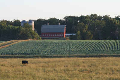
South Dakota has some of the earliest geologic history on the continent in the rock formations of the Black Hills and the Badlands. The Missouri River cuts through the center of the state. To the east of the river are low hills and lakes formed by glaciers. The land here is fertile and farms are prevalent. This area is referred to as the Drift Prairie. The Dissected Till Plains lie in the southeastern corner of the state and consist of rolling hills crossed by streams.
The Missouri River runs through the central part of South Dakota. To the east of the river, lie low hills and lakes formed by glaciers. Fertile farm country covers the area. To the west of the Missouri River, the land consists of deep canyons and rolling plains.
South Dakota Highest, Lowest, & Mean Elevations |
|
|---|---|
| Mean Elevation | 2,200 ft. |
| Highest Point | Harney Peak 7,242 ft. |
| Lowest Point | Big Stone Lake 966 ft. |
South Dakota Land Area (Square Miles) |
|
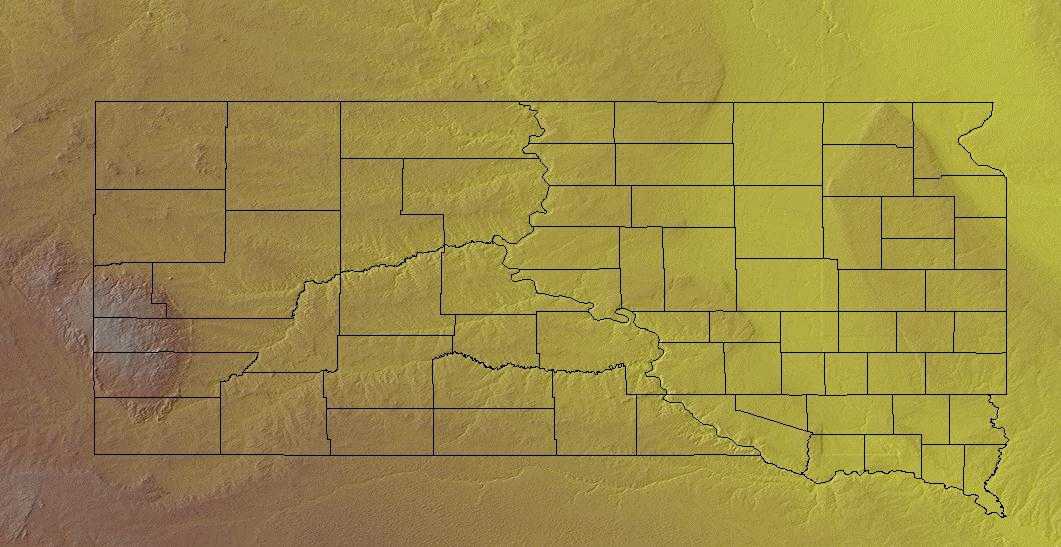
| Geographic Center | In Hughes County, 8 mi. NE of Pierre Longitude: 100° 28.7'W Latitude: 44° 24.1'N |
| Total Area | 77,116.49 sq. mi. 17th |
| Land Area | 75,884.64 sq. mi. 98.41% |
| Water Area | 1,231.85 sq. mi. 1.59% |
| Forested Land Area | |
| Dimensions (Length - Width) |
380 miles - 210 miles |
South Dakota: Physiographic Regions
South Dakota is comprised of four major land regions;
- the Drift Prairie,
- the Disected Till Plains,
- the Great Plains, and the
- Black Hills.
Drift Prairie
Most of the eastern state is covered by the Drift Prairie. It is made up of low hills and glacial lakes. The early French traders referred to this area as the Coteau des Prairies (Prairie Hills). In the north, the Prairie Hills is bordered on the east by the Minnesota River Valley and on the west by the James River Basin. The James River Basin follows the flow of the James River through South Dakota from north to south and is mostly flat land.
Dissected Till Plains
This is an area of rolling hills and is criss-crossed by many streams. This region lie in the southeastern corner of the state. The Dissected Till Plains are located in the southeastern corner of South Dakota. The region extends from Nebraska and Iowa and enters the southeastern corner of the state.
Great Plains
Most of the western 2/3 of South Dakota is the Great Plains. Between the James River Basin of the Drift Prairie and the Missouri River is the hills and valleys of the Coteau de Missouri. More rugged land that also consists of rolling hills, plains, canyons, and steep flat-topped hills called buttes lie west of the Missouri River. Buttes sometimes, in this area, rise 400 to 600 feet above the plains. Located in this area is the Badlands National Park.
Black Hills
Located in the southwestern part of South Dakota and extending into Wyoming are the Black Hills. Covering over 6,000 square miles with mountains that are from 2,000 to 4,000 feet high. Harney Peak is in the Black Hills and is 7,242 feet above sea level and is the highest point in South Dakota. One of the largest gold mines in the United States is the Homestake Mine located in this region. The Black Hills are rich in minerals such as gold, silver, copper and lead. Mt. Rushmore, the Crazy Horse Memorial, Wind Cave, and Custer National Park are located in the Black Hills.
South Dakota Landscape and Landforms:
Central Mixed-grass Prairie
The majority of the Central Mixed-grass Prairie occurs in central Kansas and Nebraska, with a small portion in southern South Dakota. The northern and western portions are covered by the Nebraska Sandhills, an area of rolling, irregular dunes interspersed with gently sloping valleys and numerous small wetlands. The remainder of the physiographic area is a dissected loess plain drained by several major rivers. Whereas all of the uplands are naturally mixed and tallgrass prairie communities, the larger river valleys support northern floodplain forests.
Northern Mixed-grass Prairie
The area includes almost all of the eastern half of South Dakota and central North Dakota from the Red River Valley on the east to the Missouri River and Montana border on the south and west. In Canada, it includes a small portion of southern Manitoba, and a swath that crosses Saskatchewan and extends into Alberta. The southern edge of this physiographic area is the terminus of a glacial moraine now marked by the course of the Missouri River. To the north, prairies give way to the Aspen Parklands. Precipitation declines from east-to-west across the northern plains, resulting in differences in the height of dominant grasses. To the east, the mixed-grass begins as topography rises out of the Tallgrass Prairie of the Red River Valley. In the United States, grass height gradually decreases beyond the western boundary of this physiographic area. Because of the glacial history of the Northern Mixed Grass and the relationship between precipitation and evapotranspiration, the area is dotted with thousands of depressions that range from permanently to periodically wet. This gives the area the name "Prairie Potholes." Internally, the various moraines (termed "coteaus") are particularly rugged and marked by potholes.
West River
West River is comprised of those areas west of the Missouri River in North Dakota and South Dakota, including the Black Hills, as well as a small portion of northwestern Nebraska. It is predominantly a grassland, with riparian woodlands along major waterways and coniferous forest in the Black Hills and other isolated highlands in the west. This area is a mixed grass prairie, but is considerably drier than either the Northern Mixed Grass Prairie physiographic area to the east or the Nebraska Sandhills of the Central Mixed Grass Prairie to the south. Because it was not recently glaciated, it lacks the prairie potholes so important to wetland birds. Large areas in the western portion of this area are highly dissected landscapes known as "badlands."

