


Washington Geography: The Land
Geography and Landforms of Washington
 Find an overview of Washington
geography, topography, geographic land regions, land areas, and major rivers.
Find an overview of Washington
geography, topography, geographic land regions, land areas, and major rivers.
Access Washington almanac, furnishing more details on the state geography, geographical and land regions, climate and weather, elevation, land areas, bordering states, and other statistical data.
Washington is bordered by Canada in the north and Oregon on the south. On the east, Washington is bordered by Idaho and on the west; it is bordered by the Pacific Ocean.
The terrain and climate of Washington divide the state into a rainy western third and a drier eastern two-thirds in the rain shadow of
the Cascade Range.
Major rivers in the state include the Columbia, the Snake and the Yakima Rivers.
Washington Highest, Lowest, & Mean Elevations |
|
|---|---|
| Mean Elevation | 1,700 ft. |
| Highest Point | Mt. Rainier 14,410 ft. |
| Lowest Point | Pacific Ocean Sea level |
Washington Land Area (Square Miles) |
|
| Geographic Center | In Chelan County, 10 mi. WSW of Wenatchee Longitude: 120° 16.1'W Latitude: 47° 20.0' N |
| Total Area | 71,299.64 sq. mi. 18th |
| Land Area | 66,544.06 sq. mi. 93.34% |
| Water Area | 4,755.58 sq. mi. 6.66% |
| Forested Land Area | 51.4% |
| Dimensions (Length - Width) |
360 miles - 240 miles |
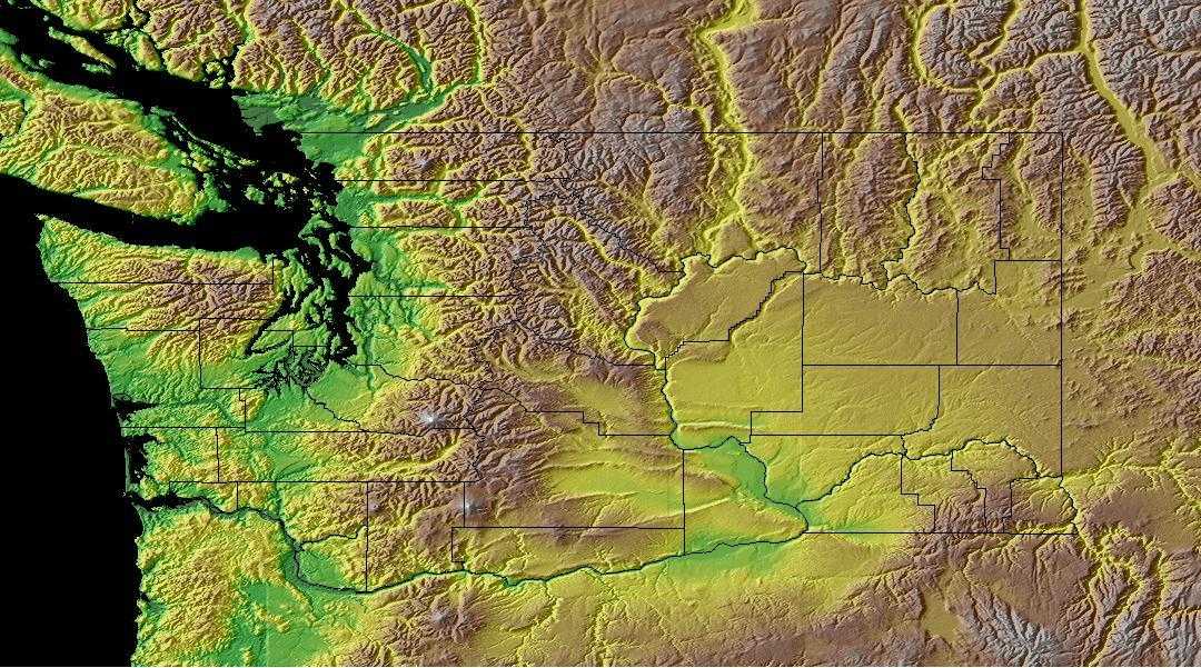
Washington: Physiographic Regions
Washington has six physiographic regions.
- Olympic Peninsula (Olympic Mountains)
- Coast Range
- Puget Sound Lowlands
- Cascade Range (Cascade Mountains)
- Columbia Plateau
- Rocky Mountains
Olympic Peninsula (Olympic Mountains)
Located in the northwest corner of Washington are the Olympic Mountains. This region is bordered on the north by the Strait of Juan de Fuca and on the west by the Pacific Ocean. Puget Sound lies to the east of the Olympic Mountains and to the south is the Coast Range. There are wild areas in the Olympic and some think they have never been explored. Most of this area lies within the Olympic National Park.
Coast Range
The Coast Range is located to the south of the Olympic Mountains. It runs into Oregon. The Willapa Hills which overlook Willapa Bay are located in the Coast Range.
Puget Sound Lowlands
These lowlands are to the east of the Olympic Mountains and the west of the Cascade Mountains. Puget Bay extends south into Washington and north into British Columbia, Canada. The Puget Sound Lowlands also include the land along the Chehalis River Also included in these lowlands is the land along the Chehalis River that runs to the Pacific Ocean between the Olympic Mountains in the north and the Willapa Hills in the south. Three fourths of Washington's population live in these lowlands which includes most of the states cities, including Tacoma and the state capital, Olympia. The Strait of Juan de Fuca connects Puget Sound to the Pacific Ocean in the north.
Cascade Range (Cascade Mountains)
This is a 700 mile chain of mountains marked by several volcanic peaks, most of them inactive. Mt. Rainier (14,410 feet) is the highest point in Washington, located in the Cascade Mountains along with Mount St. Helens which erupted in 1980. Also located here are Mount Adams (12,307 feet), Mount Baker (10,778 feet), and Glacier Peak (10,541 feet). All of the higher mountains have glaciers and permanent snow cover on their upper slopes. The lower slopes and lower mountains are carpeted with beautiful, lush forests and most are located with designated National Forest areas.
Columbia Plateau
The Columbia Plateau covers most of southern and central Washington is also referred to as the Columbia Basin. It is from 500 to 2,000 feet about sea level and surrounded by higher lands. It lies to the south and east of the great bend in the Columbia River. It is made up of dry canyons with steep walls cut into the lava thousands of years ago, called Coulees. And patches of lava lying on the surface of the plateau known as Scablands. The southeastern part of the Columbia Plateau are the rolling hills of Palouse country which provides deep fertile soil that supports much of Washington's wheat farming.
The Blue Mountains lie in the deep southeastern corner of Washington. These mountains provide land for hay and grains in the valleys and summer grazing for livestock on the slopes and are lower than the Cascades or the Olympic Mountains.
This is an arid sagebrush steppe and grassland surrounded on the north, west, and east by moister, predominantly forested, mountainous ecological regions. It is an oddly shaped physiographic area that covers portions of Washington, Oregon, Idaho, Nevada, and a small piece of northeast California. It consists of arid tablelands, intermontane basins, dissected lava plains, and widely scattered low mountains. There is a more subtle transition to the Basin and Range to the south in which hotter lowlands are dissected by isolated mountain ranges.
Rocky Mountains
Part of the Rocky Mountains cut across Washington in the northeast corner of the state. The Washington Rocky Mountains are also called the Columbia Mountains and are made up of ridges and valleys cut by the Columbia River and its tributaries including the Okanogan River. Copper, gold, lead, limestone, magnetite, silver and zinc are found in the Columbia Mountains.
The Okanogan Highlands, in the northeast, are an extension of the Rocky Mountains. Their north-south ranges, with summits that rise to more than 7,000 feet (2,100 metres), are separated by glaciated trenches. Most of the state’s metallic ores are found in this region.
The Central Rockies is a huge physiographic area, extending from northwest Wyoming over all of western Montana, the northern 2/3 of Idaho, large areas of eastern Oregon and Washington, much of southeast British Columbia and a sliver of west Alberta. It is an area of high mountains, with elevations up to 2,700 m (9,000 ft.) Glaciation has left broad flat valleys between mountain ranges. Elevation determines the dominant vegetation. Highest areas are alpine tundra. The subalpine zone is dominated by Engelmann spruce and subalpine fir, with ponderosa pine and Douglas fir in the montane zone below that. Stand-replacement fire can change forests in either of those zones to lodgepole pine or aspen. Grass and sagebrush occur under open pine forests that grade downslope into grasslands, woodlands, or shrubsteppe.
Washington Landscape and Landforms:
Southern Pacific Rainforests
This moist physiographic area extends from the Pacific coastline of Washington and Oregon inland to the crest of the Cascade Mountains. It ends arbitrarily at the Canadian border, and also includes the coastal ranges of northwestern California. Save for coastal estuaries and some inland drier valleys (the Willamette and the Puget Trough), the natural vegetation is coniferous forest. There are six coniferous forest types, defined by elevation and latitude, including the coastal Sitka spruce zone, low-elevation western hemlock/western red cedar, mid-elevation Pacific silver fir zone, subalpine mountain hemlock, a mixed-conifer zone in the Klamath/Siskiyou Mountains, and the redwood forest of northwest California.

