


Click Image to Enlarge
Iowa Counties
There are ninety-nine counties in Iowa. The first two counties, Des Moines County and Dubuque County, were created in 1834 when Iowa was still part of the Michigan Territory. In preparation for Michigan's statehood, part of Michigan Territory was formed into Wisconsin Territory in 1836]. Two years later, the western portion was split off to become Iowa Territory. The south-eastern part of Iowa Territory became Iowa, the 29th state in the union, on 28 December 1846, by which point 44 Counties had been created. Counties continued to be created by the state government until 1857, when the last county, Humboldt County, was created.Clay County, Iowa
Clay County Education, Geography, and History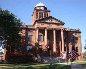
Clay County is a county located in the state of Iowa. Based on the 2010 census, the
population was 16,667. Clay County was created
on January 15, 1851. The county seat is Spencer.
Clay county is named in honor of Lieutenant
Colonel Henry Clay, Jr., who died in action in the Mexican-American War, and son of Henry Clay, famous American
statesman.
Clay County comprises the Spencer, IA Micropolitan Statistical Area.
Etymology - Origin of Clay County Name
Clay county is named for Lieutenant Colonel Henry Clay, Jr., who died during the Mexican-American War and the son of Henry Clay, the famous United States statesman.
Demographics:
County QuickFacts: CensusBureau Quick Facts
Clay County History
Clay County, established in 1851 and
organized in the fall of 1858, is named after Lieutenant Colonel Henry Clay Jr.
of the Mexican War and not the excellent clay that is found in the county, which
is used in the making of bricks.
Before its organization Clay County was attached to Woodbury County for judicial
and civil reasons. After its independence was declared, an election was held on
October 12, 1858. It was held at the home of A. S. Mead and its purpose was the
election of county officials. Of the 18 men who voted, 14 were elected to an
office.
Those offices were kept in the homes of the officers until 1859. At this time A.
W. Hubbard, Judge of the Fourth Judicial District, authorized a commission to
locate a county seat. On July 16, 1859 the commission chose the present site of
Spencer. But, due to the fact that Spencer was unimproved and no settler lived
within a 10-mile radius, it was refused by the residents of Clay.
In May 1860 the county judge received a petition asking that the county seat be
located at Peterson. An election was held, and all 10 participants voted in
favor of Peterson. Soon afterwards a courthouse was built at a cost of $6,000.
The county seat remained in Peterson until 1871. In 1871 the town of Spencer was
formally laid out, and since it was more centrally located than Peterson, the
question of moving the county seat was asked again. It was answered in an
election held in October of that same year; Spencer won the county seat by a
margin of 159 votes.
The first courthouse was built by the residents of Spencer. They formed a stock
company and sold shares. Those who could not afford a share offered their labor.
When the building was completed, it was sold to the city for $1,333. A second
building was built in 1884 at different location. It was criticized by the
residents as being plain and boring. It was the best that the county could do
because they were held to $5,000 by the law.
It was decided in 1900 that the county needed a new courthouse. The structure
was erected on the same site as the second and was ready for occupation in
September 1901. No formal dedication was held: the doors were just opened and
business was continued. This building is no comparison to the second. Costing
$60,000, $3,000 on marble alone, it is a beautiful structure.
In 1979 the Board of Supervisors decided to renovate the existing courthouse and
construct an administration building. The motion passed in August and $2.1
million was approved for the two projects. A dedication ceremony was held on
September 26, 1982, and Clay County now has two buildings that it can be proud
of.
Sources:
History of Clay County, 1886.
Sharon McKeever, Clay County Recorder, 2002
Geography: Land and Water
As reported by the Census Bureau, the county has a total area of 573 square miles (1,480 km2), of which 567 square miles (1,470 km2) is land and 5.4 square miles (14 km2) (0.9%) is water.
Clay county is located in northwest Iowa. The county is home to the large Barringer Slough wetland.
Neighboring Counties
Bordering counties are as follows:
- North: Dickinson County
- Northeast: Emmet County
- East: Palo Alto County
- Southeast: Pocahontas County
- South: Buena Vista County
- Southwest: Cherokee County
- West: O'Brien County
- Northwest: Osceola County
Education


Click Image to Enlarge
