

Click Image to Enlarge
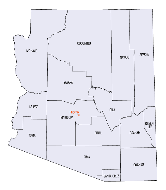
Arizona Counties
There are fifteen Counties in Arizona. There is one defunct county: Pah-Ute County formed in 1865 from Mohave County and returned in 1871. Four Counties (Mohave, Pima, Yavapai and Yuma) were created in 1864 following the organization of the Arizona Territory in 1862. The newest, La Paz County was created in 1983.La Paz County, Arizona
La Paz County Education, Geography, and History
La Paz County is a county in the western part of the state of Arizona. Based on the 2010 census, its population was 20,489, making it the second-least populous county in Arizona. La Paz County was created on November 2, 1982 from part of Yuma County. The county seat is Parker. The name of the county is the Spanish word for "the peace", and is taken from the early settlement (now ghost town) of La Paz along the Colorado River.
The Colorado River Indian Reservation is located in the western portion of the county. Part of the reservation extends westward into San Bernardino and Riverside Counties in California.
Etymology - Origin of La Paz County Name
La Paz county takes its name from that of the first county seat for Yuma County, La Paz, which relinquished that honor to Yuma (then known as Arizona City) in 1870. La paz means the peace in Spanish.
Demographics:
County QuickFacts: CensusBureau Quick Facts
La Paz County History
La Paz County, Arizona
The fifteenth county in Arizona came into existence on November 2, 1982, becoming a political entity on January 1, 1983. La Paz County consist of of land separated from its parent county, Yuma. The county is mostly north of the Gila and Salt River Base Line between townships north and south. La Paz takes its name from that of the first county seat for Yuma County. La Paz, which relinquished that honor to Yuma (then known as Arizona City) in 1870. The town of Parker is county seat for La Paz County.
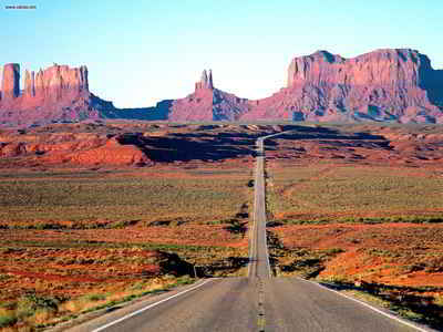
This county is created out of the southwestern portion of the Territory, and is bounded on the west by the Colorado River. The valley of the Colorado is from two to ten miles in width; the soil is rich sedimentary, and is generally covered with a dense growth of vegetation, and is well wooded with Mesquite and Cottonwood trees. Very little attempt has been made to cultivate these lands, except by the Indians. They in a rude way produce some vegetables, corn and wheat.
The soil and climate are undoubtedly well adapted to the production of cotton, rice and sugar cane, as well as the cereals, and nearly all kinds of vegetables. Experiments made in planting figs, lemons and oranges encourage the belief that these fruits can be raised in abundance.
The only obstacle in the way of extensive and profitable agriculture in the valley of this river is the frequent changes of its channel. Its waters can undoubtedly be controlled by levees and canals, and it would be policy for the government to make liberal grants of land to accomplish this object. The water once under control and this would be an inviting field for investment and enterprise.
Geography: Land and Water
As reported by the Census Bureau, the county has a total area of 4,514 square miles (11,690 km2), of which 4,500 square miles (12,000 km2) is land and 14 square miles (36 km2) (0.3%) is water.
The Gila River runs about 150 miles in a westerly course through this county; its valley is from one to three miles in width; the soil is rich and covered with vegetation, and by irrigation will produce almost anything that grows; it is uninhabited, except by station keepers along the overland mail road. These stations are usually located about fifteen miles apart.
The balance of this county is mostly high table lands, with frequent broken mountains, and is generally destitute of water; portions of the year these lauds are covered with excellent grass, but until water is increased by sinking wells, the larger portion of this belt of country will be of little value.
The Parker Strip section of the Colorado River is a major tourist
attraction, while Quartzsite is a popular destination for winter
visitors to the state.
Neighboring Counties
Bordering counties are as follows:
- North: Mohave County
- Northeast: Yavapai County
- Southeast: Maricopa County
- South: Yuma County
- Southwest: Imperial County, Calif.
- West: Riverside County, Calif.
- Northwest: San Bernardino County, Calif.
Education


Click Image to Enlarge
