

Click Image to Enlarge
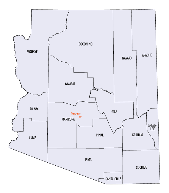
Arizona Counties
There are fifteen Counties in Arizona. There is one defunct county: Pah-Ute County formed in 1865 from Mohave County and returned in 1871. Four Counties (Mohave, Pima, Yavapai and Yuma) were created in 1864 following the organization of the Arizona Territory in 1862. The newest, La Paz County was created in 1983.Navajo County, Arizona
Navajo County Education, Geography, and History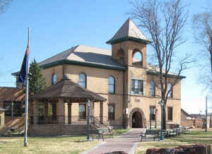
Navajo County is located in the northern part of the state of Arizona. Based on the 2010 census, its
population was 107,449. Navajo county was
created in 1895. The county seat is Holbrook.
The county is named after the Navajo people. Navajo is
from Tewa Navahu "big field," referring to the San Juan River Valley.
Navajo County comprises the Show Low, AZ Micropolitan Statistical Area.
Navajo County contains parts of the Hopi Indian reservation, the Navajo Nation and Fort Apache Indian Reservation.
Etymology - Origin of Navajo County Name
Navajo county is named after the Navajo Native American people.
Demographics:
County QuickFacts: CensusBureau Quick Facts
Navajo County History
Navajo County, Arizona
Navajo County was divided from Apache County on March 21, 1895. The first county sheriff was fabled gunman Commodore Perry Owens, who had formerly served as the sheriff of Apache County. The county was the location for many of the actions that played out during the Pleasant Valley War.
What is now Navajo County was first included in Yavapai County, but in 1879, the area was added to the newly formed Apache County.
By the time it became Navajo County, the railroad had crossed the county for more than a decade, and North America's third largest ranch, the Aztec Land and Cattle Company near Holbrook, had been established. Backed by Easterners, Aztec bought 1 million acres of land from the railroad at 50 cents an acre. A company, known as the Hashknife Outfit because of its brand, brought 33,000 longhorn cattle and 2,200 horses into northern Arizona from Texas. The county seat, Holbrook, was founded in 1881.
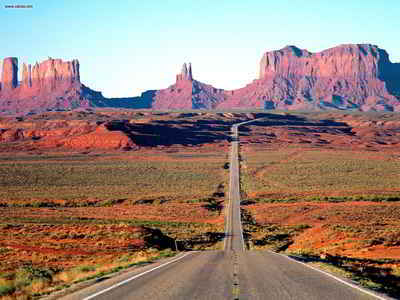
In the north is Kayenta, founded in 1909 as a trading post, and now the gateway to the Navajo Tribal Park at Monument Valley and a thriving Navajo community. Farther south is the Hopi Indian Reservation, which is completely surrounded by the Navajo Reservation. The Hopi Pueblo of Oraibi is one of the oldest continuously inhabited settlements in the United States.
Almost 66 percent of Navajo County's 9,949 square miles is Indian reservation land. Individual and corporate ownership accounts for 18 percent; the US Forest Service and US Bureau of Land Management together control 9 percent; and the state of Arizona owns 5.9 percent. All of Navajo County is an Enterprise Zone.
Today, Navajo County's principal industries are tourism, coal mining, manufacturing, timber production and ranching.
Geography: Land and Water
As reported by the Census Bureau, the county has a total area of 9,960 square miles (25,800 km2), of which 9,950 square miles (25,800
km2) is land and 9.3 square miles (24 km2) (0.09%) is water.
Many people think that Arizona is a vast, open desert without vegetation. However, Navajo County offers not only the Monument Valley, but
Keams Canyon, part of the Petrified Forest National Park, and the largest stand of Ponderosa Pines in North America.
About two-thirds of Navajo County is Navajo, Hopi and White Mountain
Apache tribal land.
Attractions include; Monument Valley, the Painted Desert and a section of the Mogollon Rim, which cuts across much of Arizona from east to west.
Neighboring Counties
Bordering counties are as follows:
- North: San Juan County, Utah
- East: Apache County
- South: Graham County
- Southwest: Gila County
- Northwest: Coconino County
Education
School districts that serve the county include:
- Blue Ridge Unified School District
- Cedar Unified School District
- Heber-Overgaard Unified School District
- Holbrook Unified School District
- Joseph City Unified School District
- Kayenta Unified School District
- Piñon Unified School District
- Show Low Unified School District
- Snowflake Unified School District
- Whiteriver Unified School District
- Winslow Unified School District


Click Image to Enlarge
