

Click Image to Enlarge
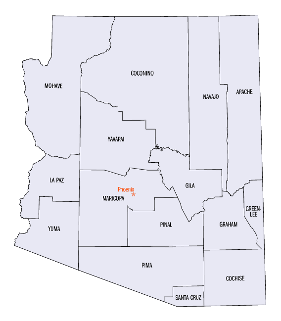
Arizona Counties
There are fifteen Counties in Arizona. There is one defunct county: Pah-Ute County formed in 1865 from Mohave County and returned in 1871. Four Counties (Mohave, Pima, Yavapai and Yuma) were created in 1864 following the organization of the Arizona Territory in 1862. The newest, La Paz County was created in 1983.Yavapai County, Arizona
Yavapai County Education, Geography, and History
Yavapai County is located near the center of the state of Arizona. Based on the 2010 census, its
population was 211,073. Yavapai county was
created in 1864. The county seat
is Prescott. Yavapai County is named for after Yavapai Native American people.
Yavapai County comprises the Prescott, AZ Metropolitan Statistical Area.
Etymology - Origin of Yavapai County Name
Yavapai County is named for after Yavapai Native American people.
Demographics:
County QuickFacts: CensusBureau Quick Facts
Yavapai County History
Yavapai County, Arizona
Yavapai county is enclosed on the north and west by Mohave County; on the east by New Mexico and the south by Maricopa County. Nearly the entire county has an altitude of from 5,000 to 6,000 feet above the level of the sea, and several mountains rise to the height of 12,000 to 14,000 feet. It contains large forests of excellent timber, and many valleys superior for agriculture. Grass is
abundant everywhere, and the advantages for stock rising cannot be
surpassed. Substantial attention has been paid to farming, and with the exception of two dry seasons, the yield has been equal to that of other favored grain growing States. The farmers of this county have depended entirely upon the rain fall to grow their crops. Experience seems to prove that irrigation will have to be resorted to in order to insure a certain yield. The most prominent streams of water in this county are the Little Colorado, Verde, Salt, Sipicue and White rivers. They all abound in excellent fish; and turkey, bear and
deer, are ample in all the mountains of Arizona.
Owing to the unfriendliness of the Apache Indians, prospecting and mining has been much retarded over a large portion of the county, but sufficient explorations have been made to demonstrate the fact that it contains extensively rich mines of gold and silver-scarcely a mountain has been examined that does not show rich deposits of these metals. Placer gold is found over a large extent of country, and during wet seasons is worked with great profit. If water can be carried to these mines by means of artificial ditches (and it is believed it can be from the Verde River), lucrative employment would be given to hundreds of miners. The discovery of gold and silver quartz lodes are so numerous that it is out of the question to give room in this pamphlet to mention but one or two of the leading ones: The Vulture mine at Wickenburg is principally of gold ore; the lode is large and well defined, and is being worked now to a depth of about 300 feet; 200 men are constantly employed, and a forty
stamp mill is regularly operated with paying results. The ore is drawn on wagons, for reduction, fifteen miles, at a heavy cost. If machinery was erected at the mine, vast quantities of ore that will not pay for transportation could be worked, and the profits on all would be proportionately greater, and this mine would take front rank as a gold producing mine. The Bradshaw mines have been but recently discovered, and have already a wide and valuable reputation. The Tiger lode gives promise of taking an important position beside the great silver bearing mines of Mexico and the United States, and there are many other lodes in this district that prospect well. There has yet been no machinery erected for the reduction of ores, but many tons have been shipped from the Tiger to San Francisco that has yielded over $1,000 00 per ton. With safety from Indians and capital to develop the mines of this county, many millions of gold and silver would be annually extracted and put in circulation.
Geography: Land and Water
As reported by the Census Bureau, the county has a total area of 8,128 square miles (21,050 km2), of which 8,123 square miles (21,040
km2) is land and 4.4 square miles (11 km2) (0.05%) is water. It has about 93% of the area of the state of New Jersey. It is larger than
three US states; Rhode Island, Delaware & Connecticut, and the District of Columbia.
The county's topography makes a dramatic transition from the lower Sonoran Desert to the south to the heights of the Coconino Plateau to the
north, and the Mogollon Rim to the east. The Highest point above sea level (MSL) in Yavapai County is Mount Union at an elevation of 7,979 ft
(2,432 m) and the lowest is Agua Fria River drainage, now under Lake Pleasant.
Neighboring Counties
Bordering counties are as follows:
- Northeast: Coconino County
- Southeast: Gila County
- South: Maricopa County
- Southwest: La Paz County
- Northwest: Mohave County
Education


Click Image to Enlarge
