

Click Image to Enlarge
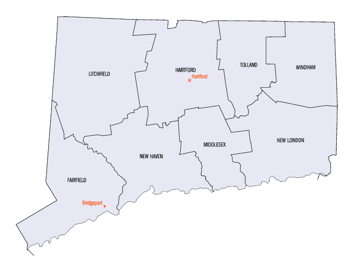
Connecticut Counties
There are currently eight Counties in Connecticut. Four of them were originally created in 1666, during the first consolidation of the colony of Connecticut. Middlesex and Tolland counties, have been created since American independence, both in 1785.Litchfield County, Connecticut
Litchfield County Education, Geography, and History
Litchfield County is a county located in northwestern Connecticut of the New York metropolitan area. Based on the 2010 census, the
population was 189,927. Litchfield County was
created on October 14, 1751 and was formed from
Fairfield County and Hartford County. The County
Seat was Litchfield (1751-1960). The county is
named after Litchfield, in England.
Litchfield County comprises the Torrington, CT Micropolitan Statistical Area, which is included in the New York-Newark, NY-NJ-CT-PA
Combined Statistical Area.
Etymology - Origin of Litchfield County Name
City of Litchfield in the UK
Demographics:
County QuickFacts: CensusBureau Quick Facts
Litchfield County History
Litchfield County is located in the northwest corner of the State of Connecticut, bordered on the east by Hartford County, to the north by Massachusetts, on the west by New York State, and to the south by Fairfield and New Haven Counties. Connecticut's sixth county, it is the largest in land mass. The total land area covered by Litchfield County is 920 square miles.
Between 1780 and 1807, several new towns were created at the boundaries between Litchfield County and other counties in Connecticut.
The town of Watertown was established in 1780 from Waterbury and was placed under Litchfield County jurisdiction. The establishment of the
town of Brookfield from part of New Milford in 1788 resulted in Litchfield County losing territory to Fairfield County. In 1796, the town
of Hartland was transferred to Hartford County. In 1798, the town of Oxford was established from part of Southbury causing Litchfield
County to lose territory to New Haven County. In 1807, the town of Southbury was transferred to New Haven County. The final boundary
change occurred on October 8, 1807, when the town of Middlebury was established from part of Woodbury.
In 1862, during the Civil War, Litchfield County raised the 2nd Connecticut Regiment of Volunteers Heavy Artillery. This regiment,
originally the 19th Connecticut Volunteer Infantry, served in the defense of Washington, D.C. from September 1862 to March 1864, at which
time it was transferred to the Army of the Potomac. On June 1, 1864, the 2nd Connecticut Heavy Artillery fought as infantry (as it
continued to do through the war) in the Battle of Cold Harbor, experiencing the heaviest proportionate losses of any Connecticut regiment
in the Civil War. The regiment remained active to the end of the war, and its final mustering out September 5, 1865.
Litchfield County has the lowest population density of any county in Connecticut and is geographically the state's largest county.
Geography: Land and Water
Litchfield county is located in northwest Connecticut. The county
is the largest county in Connecticut by area. Litchfield County is
unevenly adjoining with the portion of the Appalachian Mountains
range known as the Berkshire Mountains.
Neighboring Counties
Bordering counties are as follows:
- North: Berkshire County, Mass.
- Northeast: Hampden County, Mass.
- East: Hartford County
- Southeast: New Haven County
- South: Fairfield County
- West: Dutchess County, N.Y.
Education


Click Image to Enlarge
