


Click Image to Enlarge
Idaho Counties
There are forty-four Counties in Idaho. When Idaho became a territory in March, 1863, there were four Counties in existence: Boise, Idaho, Nez Perce and Shoshone. By the time Idaho became a state, there were 15 counties. The rest of the 44 Counties came into existence during the 30 years after Idaho became a state. Two of the former counties disappeared during this time. Alturas, which was created in 1864, was later divided into the many counties now found in central Idaho. Logan County was only in existence for six years, from 1889 to 1895. It was combined with Alturas to form Blaine County and Lincoln County, which was formed just two weeks after Logan lost its identity.Cassia County, Idaho
Cassia County Education, Geography, and History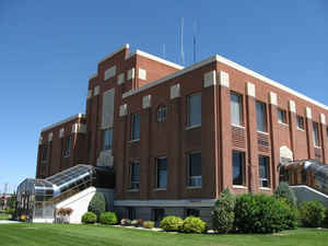
Cassia County is a county located in the state of Idaho. Based on the 2010 census, the county had a
population of 22,952. Cassia County was created
on February 20, 1879. The county seat
and largest city is Burley. The county is named for
Cassia Creek.
Cassia County is included in the Burley, ID Micropolitan Statistical Area.
Etymology - Origin of Cassia County Name
Cassia County is named for Cassia Creek, which flows through the center of the county into the Raft River.
Demographics:
County QuickFacts: CensusBureau Quick Facts
Cassia County History
Established February 20, 1879 with its county seat at Albion. The county boundaries were later reduced in 1913 by the creation of Twin Falls and Power counties. The county seat was changed to Burley on November 5, 1918. Named for Cassia Creek, which was named for one of two words: cajeaux, peasent French for raft; or James John Cazier, member of the LDS Church and of the Mormon Battalion, later a colorful captain of an emigrant train, whose name was corrupted to cassia. Locally it is also believed that the name is derived from the name of a plant.
Geography: Land and Water
As reported by the Census Bureau, the county has a total area of 2,580 square miles (6,700 km2), of which 2,565 square miles (6,640 km2)
is land and 15 square miles (39 km2) (0.6%) is water. The county's highest point is Cache Peak at an elevation of 10,339 feet (3,151 m) above
sea level in the Albion Mountains, and the lowest is Milner Lake, a reservoir on the Snake River, at 4,134 feet (1,260 m).
Cassia county is located in south Idaho.
The northern half of the county is part of the Magic Valley region of the Snake River Plain, and numerous mountain ranges extend north from
the southern boundary and diminish as they approach the river, which flows from east to west.
The Silent City of Rocks National Reserve, containing exposed granitic batholith as old as 2.5 billion years, is located in the southern part
of the county.
Neighboring Counties
Bordering counties are as follows:
- North: Blaine County; Minidoka County
- Northeast: Power County
- East: Oneida County
- Southeast: Box Elder County, Utah
- Southwest: Elko County, Nev.
- West: Twin Falls County
- Northwest: Jerome County
Education
Cassia County is served primarily by one school district, Cassia Joint School District #151, which was consolidated in the 1950s.
Public High Schools
- Burley High School - Burley
- Cassia Alternative High School - Burley
- Declo High School - Declo
- Oakley High School - Oakley
- Raft River High School - Malta


Click Image to Enlarge
