

Click Image to Enlarge
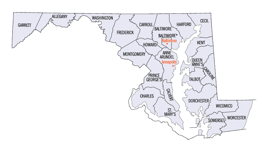
Maryland Counties
There are twenty-four counties and county-equivalents in Maryland. Though an independent city rather than a county, the City of Baltimore is considered the equal of a county. The last new county formation in Maryland occurred when Garrett County was formed in 1872 from portions of Allegany County.Prince George's County, Maryland
Prince George's County Education, Geography, and History
Prince George's County is a county in the state of Maryland, bordering the eastern portion of Washington, D.C. As of the 2010 US
Census, the population was 863,420, making it the second-most populous county in Maryland. Its county seat is Upper Marlboro.
Prince George's County is included in the Washington-Arlington-Alexandria, DC-VA-MD-WV Metropolitan Statistical Area.
Etymology - Origin of Prince George's County Name
The official name of the county, as specified in the county's charter, is "Prince George' County, Maryland". The county is named after Prince George of Denmark (1653-1708), the husband of Anne, Queen of Great Britain, and the brother of King Christian V of Denmark and Norway. The county' demonym is Prince Georgian and its motto is Semper Eadem (English: "Ever the Same"). Prince George' County is frequently referred to as "P.G." or "P.G. County", an abbreviation viewed as pejorative by some residents
Demographics:
County QuickFacts: CensusBureau Quick Facts
Prince George's County History
The Cretaceous Era brought dinosaurs to the area which left a number of fossils, now preserved in a 7.5-acre
(3.0 ha) park in Laurel. The site, which among other finds has yielded fossilized teeth from Astrodon and Priconodon species, has been
called the most prolific in the eastern United States.
In the mid to late Holocene era, the area was occupied by Paleo-Native Americans and then later, Native Americans. When the first European
settlers arrived, what is now Prince George's County was inhabited by people of the Piscataway Indian Nation. Three branches of the tribe are
still living today, two of which are headquartered in Prince George's County.
Prince George's County was created by the English Council of Maryland in the Province of Maryland in 1696 from portions of Charles and
Calvert counties. The county was divided into six districts referred to as "Hundreds": Mattapany, Petuxant, Collington, Mount Calvert,
Piscattoway and New Scotland.
A portion was detached in 1748 to form Frederick County. Because Frederick County was subsequently divided to form the present Allegany,
Garrett, Montgomery, and Washington counties, all of these counties in addition were derived from what had up to 1748 been Prince George's
County.
In 1791, portions of Prince George's County were ceded to form the new District of Columbia, along with portions of Montgomery County,
Maryland, as well as the parts of Northern Virginia; that were later returned to Virginia.
Geography: Land and Water
As reported by the Census Bureau, the county has a total area of 499 square miles (1,290 km2), of which 483 square miles (1,250 km2) is
land and 16 square miles (41 km2) (3.2%) is water.
Prince George's County lies in the Atlantic coastal plain, and its landscape is characterized by gently rolling hills and valleys. Along its
western border with Montgomery County, Adelphi, Calverton and West Laurel rise into the piedmont, exceeding 300 feet (91 m) in elevation.
The Patuxent River forms the county's eastern border with Howard, Anne Arundel, and Calvert counties.
The five regions of Prince George's County.
= North County
= Central County
= Rural Tier
= Inner Beltway
= South County
County terrain, culture and demographics differ significantly by location within the county. There are five key regions to Prince George's
County: North County, Central County, the Rural Tier, the Inner Beltway, and South County.
Neighboring Counties
Bordering counties are as follows:
- North: Howard County
- Northeast: Anne Arundel County
- Southeast: Calvert County
- Southwest: Charles County
- West: Fairfax County, Va.
- Northwest: Washington city, D.C.; Montgomery County
Education
30.1% of all residents over the age of 25 had graduated from college and obtained a bachelor's degree (17.8%) or professional degree (12.2%). 86.2% of all residents over the age of 25 were high school graduates or higher.


Click Image to Enlarge
