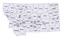
Montana Counties
There are fifty-six counties in Montana. Montana has two consolidated city-counties- Anaconda with Deer Lodge County and Butte with Silver Bow County. The portion of Yellowstone National Park that lies within Montana was not part of any county until 1997, when part of it was nominally added to Gallatin County, and the rest of it to Park County.Ravalli County, Montana
Ravalli County Education, Geography, and History
Ravalli County is a county located in the southwestern part of the state of Montana. Based on the 2010 census, the population was 40,212. Its county seat is Hamilton.
Etymology - Origin of Ravalli County Name
Anthony Ravalli, a Jesuit missionary who came to the area in 1845
Demographics:
County QuickFacts: CensusBureau Quick Facts
Ravalli County History
Ravalli County was once home to the Bitterroot Salish Indian Tribe. The tribe was first encountered in 1805 by the
Lewis and Clark Expedition, which noted the friendly nature of the tribe. The Roman Catholic Church took interest in
creating a mission in the area, and in 1841, Stevensville was founded. In 1891, the Salish tribe was relocated to the
current Flathead reservation under the Treaty of Hellgate.
In 1877, Chief Joseph and his tribe of Nez Perce passed through Ravalli county on their way to Canada in order to escape
confinement to a reservation.
Ravalli County was created by the Montana Legislature on March 3, 1893 from Missoula County. It is named after the Italian Jesuit priest
Father Antony Ravalli, who came to the Bitterroot valley in 1845.
Geography: Land and Water
As reported by the Census Bureau, the county has a total area of 2,400 square miles (6,217 km2), of which, 2,394 square miles (6,201 km2) of it is land and 6 square miles (16 km2) of it (0.25%) is water.
Ravalli County is part of a north/south mountain valley bordered by the Sapphire Mountains on the East and the Bitterroot Mountains on the
West. It is often referred to as the Bitterroot Valley, which is named for the Bitterroot Flower. The county is entirely on the Pacific Ocean
side of the Continental Divide, which follows the Idaho-Montana border from Wyoming until Ravalli County. Here it turns east into Montana,
between Chief Joseph Pass and Lost Trail Pass, and follows the Ravalli County-Beaverhead County border
Neighboring Counties
Bordering counties are as follows:
- Missoula County, Montana - north
- Granite County, Montana - east
- Beaverhead County, Montana - southeast
- Lemhi County, Idaho - south
- Idaho County, Idaho - west
Education


