


Montana Geography: The Land
Geography and Landforms of Montana
 Find
an overview of Montana geography, topography, geographic land regions, land areas, and major rivers.
Find
an overview of Montana geography, topography, geographic land regions, land areas, and major rivers.
Access Montana almanac, furnishing more details on the state geography, geographical and land regions, climate and weather, elevation, land areas, bordering states, and other statistical data.
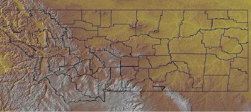
Montana is bordered by Canada on the north and by Idaho and Wyoming on the south. On the east, Montana is bordered by North and South Dakota, and on the west, it is bordered by Idaho.
Major rivers in Montana include the Clark Fork River, the Missouri River, and the Yellowstone River.
The Continental Divide separates waters running west into the Pacific Ocean and east to the Atlantic Ocean, and runs through the Rocky Mountain Region. Montana is the only state that has rivers that drain into the Gulf of Mexico, Hudson Bay, and the Pacific Ocean.
Montana Highest, Lowest, & Mean Elevations |
|
|---|---|
| Mean Elevation | 3,400 ft. |
| Highest Point | Granite Peak 12,799 ft. |
| Lowest Point | Kootenai River 1,800 ft. |
Montana Land Area (Square Miles) |
|
| Geographic Center | In Fergus County, 11 mi. W of Lewistown Longitude: 109° 38.3'W Latitude: 41° 1.9'N |
| Total Area | 147,042.40 sq. mi. 4th |
| Land Area | 145,552.43 sq. mi. 88.99% |
| Water Area | 1,489.96 sq. mi. 1.01% |
| Forested Land Area | 24.8% |
| Dimensions (Length - Width) |
630 miles - 280 miles |
Montana: Physiographic Regions
The landscape of Montana comprises two geographic areas:
- The Great Plains
- The Rocky Mountain Region
Great Plains
The Great Plains are made of high, gently rolling land interrupted by hills and wide river valleys including the Yellowstone and Missouri Rivers. Groups of mountains spring up from these plains; the Bear Paws, Big Snowy, Judith, and Little Rocky Mountains. In the southeast, badlands swept by wind and water showcase beautiful natural stone columns of red, yellow, brown, and white.
Rocky Mountain Region
This area is covered by flat, grassy valleys and mountains blanketed in fir, spruce, pine, and other evergreens. The southwest valleys are from 30 to 40 miles wide while the valleys in the north are narrower; from 1 to 5 miles wide. Many of the mountains are covered with snow for about 8 to 10 months of the year and a few active glaciers dwell in the higher altitudes. The Montana Rocky Mountains are known for their clear, cold lakes.
The Central Rockies is a huge physiographic area, extending from northwest Wyoming over all of western Montana, the northern 2/3 of Idaho, large areas of eastern Oregon and Washington, much of southeast British Columbia and a sliver of west Alberta. It is an area of high mountains, with elevations up to 2,700 m (9,000 ft.) Glaciation has left broad flat valleys between mountain ranges. Elevation determines the dominant vegetation. Highest areas are alpine tundra. The subalpine zone is dominated by Engelmann spruce and subalpine fir, with ponderosa pine and Douglas fir in the montane zone below that. Stand-replacement fire can change forests in either of those zones to lodgepole pine or aspen. Grass and sagebrush occur under open pine forests that grade downslope into grasslands, woodlands, or shrubsteppe.
Montana Landscape and Landforms:
Northern Shortgrass Prairie
The westernmost and driest part of the North American grasslands, the short grass prairie occupies regions with 10 to 12 inches of precipitation a year. A single herb layer exists and consists primarily of bunch grasses some 12 to 18 inches high. They have relatively shallow root systems. Soils are lighter brown than those under the other two formations and the calcium carbonate layer is closer to the surface. These grasslands are used today as rangeland for cattle. Many parts, including the national grasslands, are severely overgrazed and have been invaded by prickly pear cactus and other thorny plants. Due to excellent game management practices some states with short grass prairie still have large populations of pronghorn. Elk, feral horses, and mule deer also share the range with cattle. Bison still occur but are privately owned or are maintained on special federal reserves.
Wyoming Basin
As its name suggests, the Wyoming Basin is primarily in Wyoming but also extends into northern Colorado, southern Montana, and very small parts of northeast Utah and southeast Idaho. The area consists of broad intermountain basins interrupted by isolated hills and low mountains that merge to the south into a dissected plateau. It is basically a shrubsteppe, dominated by sagebrush and shadscale, interspersed with areas of shortgrass prairie. Higher elevations are in mountain shrub vegetation, with coniferous forest atop the highest areas.

