


Click Image to Enlarge
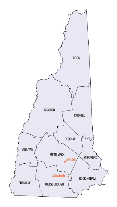
New Hampshire Counties
There are currently ten Counties in the state of New Hampshire. Five of the counties were created in 1769, when New Hampshire was still an English colony and not a state, during the first subdivision of the state into counties. The last counties created were Belknap County and Carroll County, in 1840.Strafford County, New Hampshire
Strafford County Education, Geography, and History
Strafford County is a county located in the state of New Hampshire. Based on the 2010 census, the population was 123,143. Its county seat
is Dover. Strafford County was one of the five original counties identified for New Hampshire in 1769. It was named after William Wentworth,
2nd Earl of Strafford in the mistaken belief that he was the ancestor of governor John Wentworth. Although they were distantly related,
William had no descendants.
The county was organized at Dover in 1771. In 1840 the original size of the county was reduced with the creation of Belknap County.
Strafford County is included in the Boston-Cambridge-Newton, MA-NH Metropolitan Statistical Area.
Etymology - Origin of Strafford County Name
It was named after William Wentworth, 2nd Earl of Strafford in the mistaken belief that he was the ancestor of governor John Wentworth. Although they were distantly related, William had no descendants.
Demographics:
County QuickFacts: CensusBureau Quick Facts
Strafford County History
Strafford County was one of the five original counties identified for New Hampshire in 1769. Strafford
County was organized by an act of the Colonial Legislature, passed March 19, 1771, under the administration of Governor John Wentworth, the
then Province of New Hampshire. The area was divided into five Counties, named by him, after some of his friends in England--including
Strafford, being named after the Earl of Strafford, who was a distinguished member of the Wentworth family, Thomas Wentworth, Earl of
Strafford
The areas now within Strafford County were originally called Hilton's Point, Cocheco, Dover Point and Dover Neck (depending on the locality).
Strafford's river and ocean access made it an ideal location for sawmills and shipbuilding, two of the strong industries in the 1600s. The
County of Strafford now consists of thirteen subdivisions as follows: Barrington, Dover, Durham, Farmington, Lee, Madbury, Middleton, Milton,
New Durham, Rochester, Rollinsford, Somersworth, and Strafford.
The boundaries of Strafford have varied but little, since it was originally erected into a County. The towns of Holderness and Campton, which
originally belonged to Strafford, are now part of Grafton County. The towns of Burton (now Albany), Chatham and Conway who originally belonged
to Grafton County are now part of the territory of Strafford County.
In consequence of the sparseness of the population at the time of the division, it was provided, that the Counties of Strafford and Grafton
should remained annexed to Rockinghma, until the Governor, with advice of the Council, should declare them sufficient for the exercise of
their respective jurisdictions. The County of Strafford remaiend so annexed until about the beginning of the year 1773. The first Court held
in the County, under the new organization, was the Court of General Sessions of the Peace, which took place February 23, 1773.
Strafford County is in the easterly part of New Hampshire, bounding on the State of Maine about seventy miles. It is bounded as follows: on
the north by Carroll County, on the east by York Co., Maine, on the south by Rockingham County, and on the west by Rockingham and Belknap
Counties. It embraces a territory of about 1,400 square imles and it contained, in 1775, a population of 12,513. In 1830 it amounted to
58,916. According to the 2000 federal census estimates it has a population now of 112,233.
The county is watered by the Lamprey, Bellamy, Cocheco, Isinglass, and Salmon Falls Rivers, which furnish an abundance of water-power.
The City of Rochester is the largest city in the seacoast region and is located in the middle of Strafford County, being 40 miles east of
Manchester NH. The County Seat of Strafford is Dover, located along the Cocheco River.
SOURCES:
--Juridical and other statistics of the county of Strafford in the state of New Hampshire, by Francis Cogswell; Boston: Printed by Perkins &
Marvin, 1839.
--New Hampshire as it is by Edwin A. Charleton; Claremont, N.H.; A. Kenney & Co.,, 1857
- History of Rockingham and Strafford Counties, New Hampshire : with biographical sketches of many of its pioneers and prominent men; John
Cutt, Richard Cutt; Philadelphia: J.W. Lewis & Co., 1882.
Geography: Land and Water
As reported by the Census Bureau, the county has a total area of 384 square miles (990 km2), of which 369 square miles (960 km2) is land
and 15 square miles (39 km2) (3.9%) is water.
It is the smallest county in New Hampshire by area.
Neighboring Counties
Bordering counties are as follows:
- Carroll County (north)
- York County, Maine (east)
- Rockingham County (south)
- Merrimack County (west)
- Belknap County (northwest)
Education


Click Image to Enlarge
