

Click Image to Enlarge
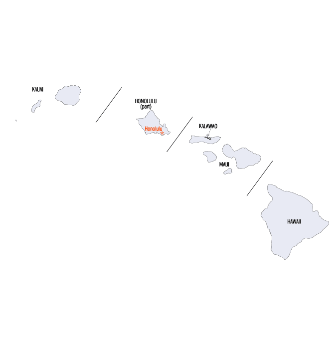
Hawaii Counties
There five counties in Hawaiʻi. All the counties were created in 1905 from unorganized territory, seven years after the Territory of Hawaii was created.Kauai County, Hawaii
Kauai County Education, Geography, and History
Kauai County is a county located in the state of Hawaii. As of
the 2010 Census the population was 67,091. Kauai
was created in 1905. The county
seat is Līhue. Kauai is a word of unknown origin; Hawaiiloa
is often credited with naming the island for his
son.
The Kapa'a Micropolitan Statistical Area includes all of Kauai County.
Etymology - Origin of Kauai County Name
Kauai is a word of unknown origin; Hawaiiloa is often credited with naming the island for his son. Native
Hawaiian tradition indicates the name's origin in the legend of Hawaiʻiloa - the Polynesian navigator attributed
with discovery of the Hawaiian Islands. The story relates how he named the island of Kauaʻi after a favorite son;
therefore a possible translation of Kauaʻi is "place around the neck", meaning how a father would carry a favorite
child. Another possible translation is "food season."
Kauaʻi was known for its distinct dialect of the Hawaiian language before it went extinct there. Whereas the
standard language today is based on the dialect of Hawaiʻi island, the Kauaʻi dialect was known for pronouncing /k/
as /t/. (In fact, Kauaʻi retained the old pan-Polynesian /t/, while Hawaiʻi has innovated and changed it.)
Therefore, the native name for Kauaʻi was Tauaʻi, and the major settlement of Kapaʻa would have been called Tapaʻa.
Demographics:
County QuickFacts: CensusBureau Quick Facts
Kauai mCounty History
Kauaʻi or Kauai (pronounced /ˈkaʊ.aɪ/ in English and [kouˈɐʔi] in Hawaiian) is the oldest of the main Hawaiian
Islands. With an area of 552.3 square miles (1,430.5 km2), it is the fourth largest of the main islands in the Hawaiian
archipelago and the 21st largest island in the United States. Known also as the "Garden Isle", Kauaʻi lies 105 miles
(170 kilometers) across the Kauaʻi Channel, northwest of Oʻahu. The
county consists of the islands of Kauaʻi, Niʻihau, Lehua, and Kaʻula.
During the reign of King Kamehameha, the islands of Kauaʻi and Niʻihau were the last Hawaiian Islands to join his
Kingdom of Hawaiʻi. Their ruler, Kaumualiʻi, resisted Kamehameha for years. King Kamehameha twice prepared a huge armada
of ships and canoes to take the islands by force and twice failed; once due to a storm, and once due to an epidemic. In
the face of the threat of a further invasion, however, Kaumualiʻi decided to join the kingdom without bloodshed, and
became Kamehameha's vassal in 1810, ceding the island to the Kingdom of Hawaiʻi upon his death.
Geography: Land and Water
Kauai county is located in
northwest Hawaii. The county origins are volcanic. The highest peak on this mountainous island is Kawaikini at 5,243 feet (1,598 m).
The second highest peak is Mount Waiʻaleʻale near the center of the island, 5,148 feet (1,569 m) above sea level.
One of the wettest spots on Earth, with an annual average rainfall of 460 inches (11,700 mm), is located on the east
side of Mount Waiʻaleʻale. The high annual rainfall has eroded deep valleys in the central mountains, carving out
canyons with many scenic waterfalls. On the west side of the island, Waimea town is located at the mouth of the
Waimea River, whose flow formed one of the Waimea Canyon, one of the most scenic canyons in the world, and which is
part of Waimea Canyon State Park. At 3,000 feet (914 m) deep, Waimea Canyon is often referred to as "The Grand
Canyon of the Pacific".
Neighboring Counties
Bordering counties are as follows:
- Surrounding area: North Pacific Ocean
Education


Click Image to Enlarge
