

Click Image to Enlarge
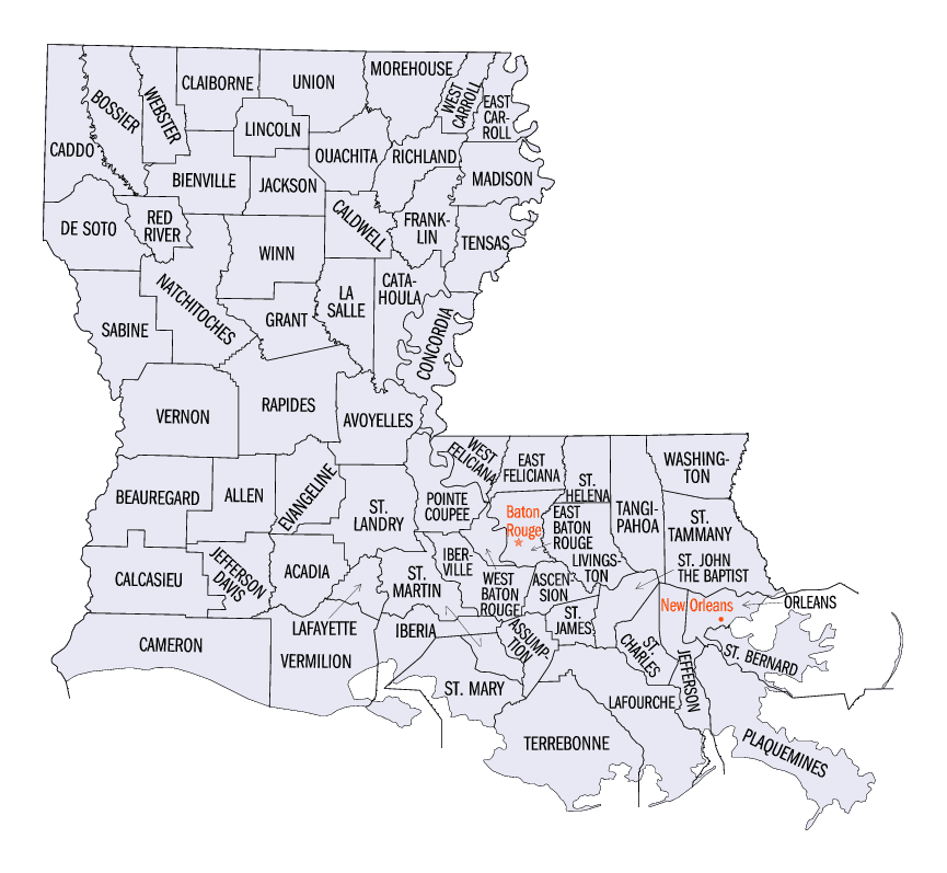
Louisiana Parishes
Louisiana is divided into sixty-four parishes. On March 31, 1807, the territorial legislature divided the state into 19 parishes, without getting rid of the old counties (which continued to exist until 1845). In 1811, a constitutional convention organized the state into seven judicial districts, each consisting of groups of parishes. In 1816, the first official map of the state used the term, as did the 1845 constitution. Since then, the official term has been parishes.Livingston Parish, Louisiana
Livingston Parish Education, Geography, and History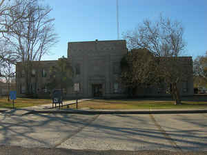
Livingston Parish is a parish located in the state of Louisiana. Based on the 2010 census, the
population was 128,026. Livingston Parish was
created on February 10, 1832. The parish
seat is
Livingston. The parish is named in honor of United States Secretary of State Edward Livingston.
Livingston Parish is part of the Baton Rouge, LA Metropolitan Statistical Area.
Etymology - Origin of Livingston Parish Name
The parish was named in honor of United States Secretary of State Edward Livingston.
Demographics:
County QuickFacts: CensusBureau Quick Facts
Livingston County History
Livingston Parish was created on February 10, 1832, from St. Helena Parish and the parish was named in honor of US
Secretary of State Edward Livingston. The Parish seat is Livingston. On October 15, 1875, the parish courthouse at
Port Vincent burned, apparently destroying the official records which were maintained there.
Livingston Parish is in the central part of the eastward-projecting southern half of Louisiana. The southeastern corner
is about 35 miles east of Baton Rouge. Livingston Parish is known as one of the Florida Parishes of Louisiana; it was a
part of West Florida until 1810. On September 22 or that year, the Spanish fort at Baton Rouge was captured by a band of
cavalry and infantry made up of settlers from the West Florida area. Four days later, on September 26, a declaration of
independence of the State of West Florida was issued. It has been asserted by one authority that the majority of foot
soldiers of the rebel force and indeed a majority of that force itself, were volunteers from the Livingston Parish
settlement of Springfield. On October 27, 1810, upon petition of the West Florida revolter's, West Florida between
Mississippi and Pearl Rivers was annexed to the United States by Presidential proclamation.
Most compilers agree that the parish was named in honor of either Robert or Edward Livingston; however, they cannot
unanimously agree on either one. Clark Forest Jr. in his article entitled "Various Locations of the Livingston Parish
Courthouse" submits that the parish is named in honor of Edward Livingston.
Since its creation in 1832 from the southern portion of St. Helena Parish, Livingston has had five different parish seats, which may be a record of sorts for Louisiana Parishes.
No original records have been found to establish the location of the parish's first seat of justice, but secondary
sources indicate it was at Van Buren. Information is contained in an act passed by the Louisiana Legislature on
March 13, 1835 entitled "To Remove the Seat of Justice form Van Buren to Springfield, in the Parish of Livingston."
In the 1850's, after completion of the New Orleans to Jackson Railroad, pressure mounted to move the courthouse to a
site along the vote on changing their courthouse location in 1871. The following year the legislature enacted Act 83
which stated the seat of justice would be located at Port Vincent.
On October 15, 1875, the parish courthouse was moved from Centerville to Livingston, three acts were passed by the
Legislature authorizing the removal of the courthouse to some point on the railroad. A referendum was finally held
in 1941, and the town of Livingston was approved as the fifth and final courthouse site.
Livingston Parish County was created on February 10, 1832. It was originally part of the Florida Parishes. The name
is thought to derive from a US Senator and Secretary of State under Andrew Jackson named Edward Livingston.
However, contradicting arguments state that Livingston Parish was named after Robert Livingston, a well known lawyer
and negotiator of the Louisiana Purchase as a minister to France.
Livingston Parish was one of the earliest settled parishes of the state, with both French and Spanish colonists
settling here in the early 1700s in the Lake Maurepas area. To get to New Orleans the early settlers traveled the
Amite River to Lake Maurepas then crossed the narrow pass into Lake Pontchartrain. At that time, the industry
primarily was centered on farming, lumbering, and harvesting fish and seafood from the waterways. Livingston became
the parish seat in 1941 when the courthouse was moved there from Centerville. Livingston Parish was incorporated on
November 4, 1955, with the following officials: Winson Hoover, Mayor; Victor Smart; Fuqua Sibley and Willie Lee
Duffy, Aldermen; and Johnnie Sartwell, Marshall. The growth of the community was lead by the construction of the
present Illinois Central Gulf rail line in 1854 and 1856.
In the following years to come the parish was embroiled with the rest of the country in the Civil War. Some 14
engagements of the Civil War were fought in Livingston Parish between 1862 and 1865. They included eight battles
fought in the vicinity of the Amite River, one at Benton's Ferry, two at French Settlement, two in the Springfield
area and one on the Tickfaw River. In 1869, the parish lost territory when Tangipahoa Parish was created. It later
gained additional land when Maurepas Island was made part of the parish. Today, Livingston Parish has eight
municipalities, with Denham Springs being the largest. Other municipalities are Albany, French Settlement, Killian,
Livingston (the parish seat), Port Vincent, Springfield and Walker. As in the past, the harvesting of forest
products and being the parish seat still plays a major role in the economic life of the town.
Geography: Land and Water
As reported by the Census Bureau, the parish has a total area of 703 square miles (1,820 km2), of which 648 square miles (1,680 km2) is land and 55 square miles (140 km2) (7.8%) is water.
Livingston Parish is located in southeast Louisiana. Tickfaw State Park, on the Tickfaw River is located in this parish.
Neighboring Parishes
Bordering parishes and counties are as follows:
- North: St. Helena Parish
- Northeast: Tangipahoa Parish
- Southeast: St. John the Baptist Parish
- Southwest: Ascension Parish
- Northwest: East Baton Rouge Parish
Education
The Livingston Parish Public Schools operates all public schools in the parish.


Click Image to Enlarge
