

Click Image to Enlarge
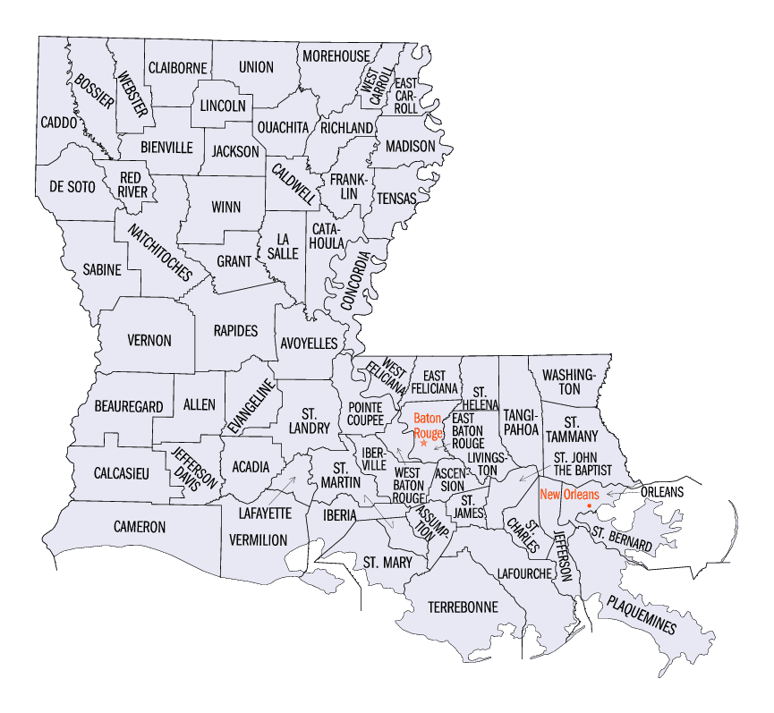
Louisiana Parishes
Louisiana is divided into sixty-four parishes. On March 31, 1807, the territorial legislature divided the state into 19 parishes, without getting rid of the old counties (which continued to exist until 1845). In 1811, a constitutional convention organized the state into seven judicial districts, each consisting of groups of parishes. In 1816, the first official map of the state used the term, as did the 1845 constitution. Since then, the official term has been parishes.St. John The Baptist Parish, Louisiana
St. John The Baptist Parish Education, Geography, and History
St. John the Baptist Parish is a parish located in the state of Louisiana. Based on the 2010 census, the population was 45,924. The
parish seat is Edgard, an unincorporated area, and the largest city is LaPlace, also unincorporated. St. John the Baptist Parish was
established in 1807 as one of the original 19 parishes of the Territory of Orleans, which became the state of Louisiana.
St. John the Baptist Parish is part of the New Orleans-Metairie, LA Metropolitan Statistical Area.
Etymology - Origin of St. John The Baptist Parish Name
The parish was named in honor of Saint John the Baptist.
Demographics:
County QuickFacts: CensusBureau Quick Facts
St. John The Baptist County History
St. John the Baptist Parish was created on March 31, 1807. It is one of the 19 parishes, which were created by dividing the Territory of New Orleans. The parish was named in honor of Saint John the Baptist. The Parish seat is Edgard
Geography: Land and Water
As reported by the Census Bureau, the parish has a total area of 348 square miles (900 km2), of which 213 square miles (550 km2) is land
and 135 square miles (350 km2) (39%) is water. It is the third-smallest parish in Louisiana by land area and fifth-smallest by total area.
St. John the Baptist Parish, Louisiana is located on the Mississippi River approximately 130 miles (210 km) upriver from the Gulf of Mexico
and 30 miles (48 km) upriver from the City of New Orleans. The area, known as the River Region, has an abundance of natural resources and a
mild "Sunbelt" climate. pelts. High silica sands, lime, clays, timber, seafood, and various agricultural products are also produced in
abundance.
St. John the Baptist Parish is bisected by the Mississippi River. Though the River actually separates the Parish into northern and southern
parts, the former is still referred to as the "east bank" and the latter as the "west bank." The Mississippi provides an important
transportation corridor which supports the heavy industry located in the area.
St. John the Baptist Parish is bordered by St. Charles Parish and Lake Pontchartrain to the east, Lake Pontchartrain and Lake Maurepas to the
north, Lafourche Parish and Lac des Allemands to the south, and St. James Parish to the west. It is one of four parishes which comprise the
"River Parishes;" St. John Parish is the heart of the "River Parishes." This section of the state, also consisting of St. James, Ascension,
and St. Charles Parishes, makes up the area along the Mississippi River between New Orleans and Baton Rouge. All of these parishes are home to
at least one major chemical- and/or petroleum-processing facility, the primary sources of employment in the region.
Much of the parish is either open water or wetlands. The wetlands are currently protected by federal law and development is limited to what is
permitted by the US Army Corps of Engineers and/or the Federal Wildlife and Fisheries Department.
Higher ground in the parish is found in an alluvial plain which generally borders the Mississippi River on both sides. Soil deposits from the
Mississippi's annual flooding created a rich and fertile area which has historically been intensively farmed (sugar cane, soybeans, feed corn,
and occasional cotton). This fact, and the natural transportation corridor supplied by the river, resulted in the creation of numerous farms
and plantations along the lower Mississippi Valley.
Many of these plantations were merely large tracts of land with modest or average-sized homes and outbuildings found on the higher ground.
Several, however, were improved with palatial mansions. Three of the larger homes have survived in St. John Parish, as noted in the History
above.
The higher ground along the banks was used to grow crops, while the wetlands were valued for their abundant timber, hunting and fishing. For
years development in the River Parishes was limited to those areas that were high and less prone to flooding. Until the existing levees and
pump systems were built, however, few places were truly safe from high water. Even today, most of the parish is considered a flood hazard area
(as per FEMA Flood Maps).
Neighboring Parishes
Bordering parishes and counties are as follows:
- North: Tangipahoa Parish
- East: Lake Pontchartrain
- Southeast: St. Charles Parish
- South: Lafourche Parish
- Southwest: St. James Parish
- West: Ascension Parish
- Northwest: Livingston Parish
Education
The St. John the Baptist Parish School Board operates 10 public schools within the parish, the Archdiocese of New Orleans oversees 5 religious schools within the parish and there are 2 privately run schools within the parish.


Click Image to Enlarge
