


Click Image to Enlarge
Oregon Counties
There are thyirty-six counties in the state of Oregon. The Oregon Constitution does not explicitly provide for county seats.Benton County, Oregon
Benton County Education, Geography, and History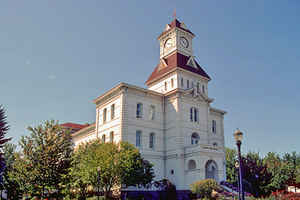
Benton County is a county located in the state of Oregon. Based on the 2010 census, the population was 85,579. Its county seat is
Corvallis. The county was named after Thomas Hart Benton, a US Senator who advocated American control over the Oregon Country.
Benton County is designated as the Corvallis, OR Metropolitan Statistical Area, which is included in the Portland-Vancouver-Salem, OR-WA
Combined Statistical Area. It is located in the Willamette Valley.
Etymology - Origin of Benton County Name
Named in honor of Senator Thomas Hart Benton of Missouri, who was instrumental in promoting the development of Oregon Country.
Demographics:
County QuickFacts: CensusBureau Quick Facts
Benton County History
Benton County was established by the
Provisional Legislature in 1847. It was named in honor of Senator Thomas Hart
Benton of Missouri, who was instrumental in promoting the development of Oregon
Country. Carved from Polk County, Benton County stretched from the Polk County
boundary south to the California border and from the Pacific Ocean east to the
Willamette River. Umpqua, Lane, Douglas, Jackson, Lincoln, Josephine, Curry, and
Coos Counties were created from portions of the original Benton County. Today
Benton County occupies 679 square miles of the central Willamette Valley and is
bordered on the east by the Willamette River and Linn County, on the west by the
summit of the Coast Range and Lincoln County, on the north by Polk County, and
on the south by Lane County.
The city of Marysville, later renamed Corvallis, became the county seat in 1851.
The first county courthouse was erected in 1854. The second courthouse, built in
1889, is the oldest in Oregon that is still used for its original purpose. It
was extensively renovated in 1976 to restore and preserve the historic character
of the building. Nearby buildings house those offices not located in the
courthouse.
At the time of its creation, Benton County government consisted of two or more
justices of the peace acting as county commissioners; a judicial system
including circuit, probate, and justice courts; clerks for each court; law
enforcement offices of sheriff and coroner; and the tax and finance offices of
the assessor, tax collector, and treasurer. In 1972 a home rule charter was
passed in Benton County and the governing body of the county became a
three-member board of commissioners.
Benton County was created out of land originally inhabited by the Klickitat
Indians. All Indian claims to land within Benton County were ceded in the Treaty
of Dayton in 1855. In 1862 Corvallis became the site of the Oregon State
Agricultural College, known today as Oregon State University. Along with the
university, agriculture, lumber, and wood products form the economic base of the
county. The 2000 population of 78,153 marked a 10.37% increase over the 1990
population.
Geography: Land and Water
As reported by the Census Bureau, the county has a total area of 679 square miles (1,760 km2), of which 676 square miles (1,750 km2) is
land and 2.7 square miles (7.0 km2) (0.4%) is water. It is the fourth-smallest county in Oregon by land area and third-smallest by total area.
Neighboring Counties
Bordering counties are as follows:
- Polk County (north)
- Lincoln County (west)
- Linn County (east)
- Lane County (south)
Education


Click Image to Enlarge
