


Click Image to Enlarge
Oregon Counties
There are thyirty-six counties in the state of Oregon. The Oregon Constitution does not explicitly provide for county seats.Columbia County, Oregon
Columbia County Education, Geography, and History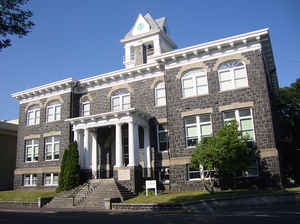
Columbia County is a county located in the state of Oregon. Based on the 2010 census, the population was 49,351. The county seat is St.
Helens. It was named for the Columbia River, which forms its eastern and northern borders.
Columbia County is included in the Portland-Vancouver-Hillsboro, OR-WA Portland metropolitan area.
Etymology - Origin of Columbia County Name
Columbia County, named for the Columbia River, was created in 1854 from the northern half of Washington County.
Demographics:
County QuickFacts: CensusBureau Quick Facts
Columbia County History
Columbia County, named for the
Columbia River, was created in 1854 from the northern half of Washington County.
It covers 646 square miles and is bounded on the north and east by the Columbia
River, on the west by Clatsop County, and on the south by Washington and
Multnomah Counties. Columbia County was the sixteenth county created in Oregon
and is the third smallest county in Oregon after Multnomah and Hood River
Counties.
Lewis and Clark explored this area in 1805-1806. Early settlements were
established by fur traders as early as 1810. As American immigration increased
in the mid-1840s, lasting settlements began to appear. The Yakima Indian War
(1855-1859) drove many Washington Territory residents south of the Columbia
River and helped boost the populations of St. Helens and Columbia City.
The first district court met in 1854 in Milton, which served as the county seat
until 1857 when it was moved to St. Helens. St. Helens was founded in 1848 and
took its name from the nearby Mt. St. Helens. The present courthouse was built
in 1906, and an annex was constructed in 1968. Most county offices are now
housed in the annex. A new sheriff's office and jail facility were recently
opened at another location.
Columbia County had a county court form of government until 1971 when a board of
commissioners was elected. The 2000 population of 43,560 represented a 15.98%
increase over 1990.
The primary industries of Columbia County are timber, fishing, water
transportation, dairying, horticulture, and recreation. The extensive stands of
old growth timber, which had attracted many of the early settlers to the area,
were completely logged over by the 1950s. Second growth timber provides the raw
material for local lumber and paper mills. The Trojan Nuclear Plant, located
near Rainier, was in operation from 1975 to 1993.
Geography: Land and Water
As reported by the Census Bureau, the county has a total area of 688 square miles (1,780 km2), of which 657 square miles (1,700 km2) is
land and 31 square miles (80 km2) (4.5%) is water. It is the third-smallest county in Oregon by land area and fourth-smallest by total area.
Neighboring Counties
Bordering counties are as follows:
- Clatsop County (west)
- Washington County (south)
- Multnomah County (southeast)
- Clark County, Washington (east)
- Cowlitz County, Washington (northeast)
- Wahkiakum County, Washington (northwest)
Education


Click Image to Enlarge
