


Click Image to Enlarge
Oregon Counties
There are thyirty-six counties in the state of Oregon. The Oregon Constitution does not explicitly provide for county seats.Crook County, Oregon
Crook County Education, Geography, and History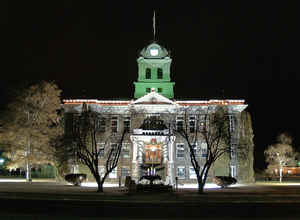
Crook County is a county located in the state of Oregon. Based on the 2010 census, the population was 20,978. The county seat is
Prineville. The county is named after George Crook, a US Army officer who served in the American Civil War and various Indian Wars.
Crook County comprises the Prineville, OR Micropolitan Statistical Area, which is included in the Bend-Redmond-Prineville, OR Combined
Statistical Area.
Etymology - Origin of Crook County Name
It was created from the southern part of Wasco County and named after US Army Major-General George Crook, a hero of the Snake Indian Wars.
Demographics:
County QuickFacts: CensusBureau Quick Facts
Crook County History
Crook County was established on
October 24, 1882. It was created from the southern part of Wasco County and
named after US Army Major-General George Crook, a hero of the Snake Indian
Wars.
Crook County is situated in the geographic center of Oregon. It has been reduced
from its original size of 8,600 square miles to 2,986 square miles by the
creation of Jefferson County in 1914 and Deschutes County in 1916. The current
boundaries were established in 1927. Crook County is bounded by Jefferson and
Wheeler Counties to the north, Grant and Harney Counties to the east, and
Deschutes County to the south and west.
In 1882 the Legislative Assembly established Prineville as the county seat. The
voters confirmed the choice of Prineville, the only incorporated town in the
county, in the 1884 general election. Prineville was named in honor of the
town's first merchant, Barney Prine.
The first courthouse was a one story wooden structure at the corner of West 5th
and Main Streets. In 1885 a two story wooden structure was built for $5,474. By
1905 this building was considered unsafe to store the county's records, and a
$16,526 bid was accepted to erect a new, brick and stone courthouse. The
building was completed in 1909, at a cost $48,590, and remodeled in the early
1990s.
The government of Crook County consisted originally of a county judge, two
county commissioners, clerk, treasurer, and sheriff. The position of school
superintendent appeared by 1899. The county also added an assessor.
The first census in 1890 showed a population of 3,244 excluding the Indians.
There has been a fluctuation in the population's growth. The last several
censuses have shown an increase in inhabitants with the 2000 population given at
19,182 representing a 35.94% increase from 1990.
Routes over the Cascades were difficult to find and traverse, thus delaying
development in the area until access was more developed. The first effort was in
1862 when a supply train with cattle crossed the Scott Trail. This was also the
first group of non-natives to spend the winter in central Oregon. The discovery
and development of the Santiam Pass in the 1860s made development of the area
much easier. The economy of the county is based on agriculture and forestry.
Agriculture is supported by the development of irrigation districts, which
permits the raising of hay, grain, mint, potatoes, and seed. Range and forest
lands allow grazing for a sizable livestock industry. The Ochoco National
Forest's stand of ponderosa pine is the main source of lumber. As the lumber
industry suffers with restricted log cutting, tourism and recreation are helping
to strengthen the economy.
Geography: Land and Water
The county is located in the geographic center of Oregon. As reported by the Census Bureau, the county has a total area of 2,987 square
miles (7,740 km2), of which 2,979 square miles (7,720 km2) is land and 8.2 square miles (21 km2) (0.3%) is water. The largest body of water in
Crook County is the Prineville Reservoir. The county has been reduced from its original size of 8,600 square miles (22,000 km2) by the
creation of Jefferson County in 1914 and Deschutes County in 1916. The present boundaries were established in 1927.
The oldest geological formation in Oregon is in the southeastern corner of Crook County, near its boundary with Grant County. This formation
is an outcropping of Devonian limestone created from a larger reef when most of Oregon was covered by water.
Neighboring Counties
Bordering counties are as follows:
- Deschutes County - southwest
- Jefferson County - north
- Wheeler County - north
- Grant County - east
- Harney County - southeast
Education


Click Image to Enlarge
