


Click Image to Enlarge
Oregon Counties
There are thyirty-six counties in the state of Oregon. The Oregon Constitution does not explicitly provide for county seats.Harney County, Oregon
Harney County Education, Geography, and History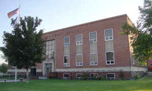
Harney County is a county located in the state of Oregon. Based on the 2010 census, the population was 7,422, making it the fifth-least populous county in Oregon. The county seat is Burns. Established in 1889, the county is named in honor of William S. Harney, a military officer of the period, who was involved in the Pig War and popular in the Pacific Northwest.
Etymology - Origin of Harney County Name
The county was named after the lake that lies within its territory, which was named in honor of General William S. Harney, commander of the Department of Oregon of the US Army in 1858-1859.
Demographics:
County QuickFacts: CensusBureau Quick Facts
Harney County History
Harney County was created from the
southern two-thirds of Grant County on February 25, 1889. It is located in the
high desert country in the southeast portion of the state and is the largest
county in Oregon comprising 10,228 square miles. Counties with contiguous
borders include Malheur to the east; Lake, Deschutes, and Crook to the west;
Grant to the north; and the State of Nevada to the south. The county was named
after the lake that lies within its territory, which was named in honor of
General William S. Harney, commander of the Department of Oregon of the US
Army in 1858-1859.
The county's principal city and its administrative seat, Burns, was officially
established in 1884 and incorporated upon the county's creation in 1889. It was
named for the Scottish poet Robert Burns by an early settler and County
Commissioner George McGowan. The original county courthouse was constructed in
1890 as the Smith and Young building. The building was purchased by citizens of
Burns and donated to the county as an inducement to voters during the struggle
that took place between Burns and Harney over the designation of the county
seat. The current courthouse was constructed in 1942.
Established by state legislation, elected officials have included a judge,
county commissioners, clerk, auditor, recorder, sheriff, treasurer, assessor,
surveyor, coroner, and school superintendent.
Three industries, cattle raising, sheep raising, and timber, have traditionally
provided the county's economic base. The railroad, which extended into the area
in 1883, served as a catalyst to the cattle industry but later contributed to
its decline by bringing farmers and sheep men to the area thus creating
increased competition for productive land. Harvesting and breeding of wild
horses was lucrative for a period. Tourism based on sports and recreation is on
the rise.
Harney County's population is primarily concentrated in a small urbanized sector
of Burns-Hines with the remainder mostly in the Harney Basin. The county's
population was recorded as 2,559 during the 1890 census and rose steadily until
the decade of 1930-40, and then resumed an upward curve until the 1980s. The
county experienced a net out migration of nearly fifteen percent in the 1980s
primarily due to the closure of the lumber mill in Burns. The 2000 population of
7,609 represented a 7.78% increase over 1990.
Although Harney County lands were open to homesteading from 1862 to 1934, the
federal Bureau of Land Management still owns more than three million acres.
Facilitated on the national level by the Carey Act of 1894, arid land in Harney
County was donated to the state for irrigation and settlement, but all water
development efforts failed. Eventually all land claims under the reclamation
legislation were abandoned or nullified. Malheur Wildlife Refuge was established
in 1908 and expanded in 1936. The refuge now includes 159,872 acres. Not the
least significant of federal government lands associated with Harney County is
the Malheur River Indian Reservation.
In addition to Malheur and Harney Lakes, other geographic landmarks of the
county include the 10,000-ft high Steens Mountain known for its lava formations.
Borax has been mined in the Steens area, and uranium has been found on its south
side.
Geography: Land and Water
Harney County has a population of less than 8,000 occupying a land area about two-thirds the size of Denmark, shown in this overlay.
As reported by the Census Bureau, the county has a total area of 10,226 square miles (26,490 km2), of which 10,133 square miles (26,240
km2) is land and 93 square miles (240 km2) (0.9%) is water. It is the largest county in Oregon by area and the tenth-largest county in the
United States (excluding boroughs and census areas in Alaska).
Steens Mountain is the county's most prominent geographical feature, rising 9,700 feet (3,000 m) above sea level and spanning many miles
across a region that is otherwise fairly flat. To its southeast is the Alvord Desert - the driest place in Oregon - and the Trout Creek
Mountains, which extend south into Nevada. South of Steens Mountain, the Pueblo Mountains are another remote range in Oregon and Nevada. North
of Steens Mountain lies the Harney Basin, which contains Malheur Lake and Harney Lake.
Neighboring Counties
Bordering counties are as follows:
- Lake County (west)
- Deschutes County (northwest)
- Crook County (northwest)
- Grant County (north)
- Malheur County (east)
- Humboldt County, Nevada (south)
- Washoe County, Nevada (southwest)
Education


Click Image to Enlarge
