


Click Image to Enlarge
Oregon Counties
There are thyirty-six counties in the state of Oregon. The Oregon Constitution does not explicitly provide for county seats.Hood River County, Oregon
Hood River County Education, Geography, and History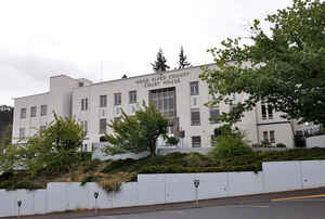
Hood River County is a county located in the state of Oregon. Based on the 2010 census, the population was 22,346. The county seat is
Hood River. The county was established in 1908 and is named for the Hood River, a tributary of the Columbia River.
Hood River County comprises the Hood River, OR Micropolitan Statistical Area.
Etymology - Origin of Hood River County Name
Mt. Hood was named in 1792 after Lord Hood (Samuel) who, among other things, served in the British Navy during the American Revolutionary War.
Demographics:
County QuickFacts: CensusBureau Quick Facts
Hood River County History
At the turn of the twentieth century,
the people of the Hood River region in the northwest portion of Wasco County
expressed a desire for political separation from the parent county. The passage
of a statewide initiative established Hood River as the thirty-fourth county of
the state. It was made official by a governor's proclamation on June 23, 1908.
Hood River County was named after Hood River and Mt. Hood which are both located
within its boundaries. Mt. Hood was named in 1792 after Lord Hood (Samuel) who,
among other things, served in the British Navy during the American Revolutionary
War.
The county's boundaries have remained unchanged throughout its existence. It is
bordered by Wasco County to the east, by Clackamas and Multnomah Counties to the
west, and by the Columbia River to the north. Hood River County is the second
smallest county in terms of size in the state, outranking only Multnomah County,
with a total area of 533 square miles.
The City of Hood River, first platted in 1881, has been the county seat since
the county's creation. The first county courthouse was an old primary school
building. In 1937, after failing to approve a new courthouse, the county was
forced to purchase the Butler Bank Building, which housed the county government
until 1954 when the present courthouse was constructed.
Initially, county officials included the county judge, two county commissioners,
sheriff, clerk, treasurer, assessor, school superintendent, surveyor, and
coroner. In 1964, Hood River County adopted the home rule form of government. A
five-member elected board of commissioners creates ordinances and resolutions to
govern the county. The commission appoints a county administrator to oversee
operations of county services. Except for an elected sheriff, all county
department heads are selected by and responsible to the commission. Several
specialized advisory boards, committees, and commissions give the board advice
and recommendations concerning various county services.
The 2000 population of Hood River County was 20,411. This represented a 20.75%
increase from 1990.
The first permanent settlers in Hood River County filed a donation land claim in
1854; by 1880 seventeen families lived in the region. By the latter part of the
nineteenth century farmers of Japanese, Finnish, German, and French ethnicity
had settled in the valley. The Columbia River Highway was completed in 1922 from
Portland to The Dalles, making the towns of Hood River County more accessible to
people and commerce from throughout the Columbia River Gorge and the state.
The principal industries of Hood River include agriculture, timber,
hydroelectric production, and recreation. The fertile Hood River Valley has an
ideal climate for the production of apples, cherries, peaches, and pears. It
also offers recreational activities such as snow skiing, yachting, and fishing
which bring both people and capital to compensate for the decline in logging and
hydroelectric production. The Columbia River near Hood River is a premier
windsurfing area and attracts windsurfers from throughout the United States and
around the world.
Geography: Land and Water
Hood River County is 533 square miles (1,380 km2), of which 522 square miles (1,350 km2) is land and 11 square miles (28 km2) (2.1%) is
water. It is the second-smallest county in Oregon by area. Elevation ranges from 60 feet (18 m) above sea level at Cascade Locks in the
northwest to 11,235 feet (3,424 m) at the summit of Mt. Hood, the highest point in Oregon.
Hood River County contains the entirety of the 217,337 acres (87,953 ha) Hood River watershed, which covers nearly two-thirds of the county.
This watershed includes four main sub-basins: the West Fork Hood River, the Middle Fork Hood River, the East Fork Hood River, and the Hood
River Mainstem (the lower river and its tributaries).
Neighboring Counties
Bordering counties are as follows:
- Multnomah County - west
- Clackamas County - southwest
- Wasco County - southeast
- Klickitat County, Washington - northeast
- Skamania County, Washington - north
Education


Click Image to Enlarge
