


Click Image to Enlarge
Oregon Counties
There are thyirty-six counties in the state of Oregon. The Oregon Constitution does not explicitly provide for county seats.Lane County, Oregon
Lane County Education, Geography, and History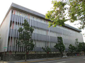
Lane County is a county located in the state of Oregon. Based on the 2010 census, the population was 351,715, making it the fourth-most
populous county in Oregon. The county seat is Eugene. It is named in honor of Joseph Lane, Oregon's first territorial governor.
Lane County comprises the Eugene, OR Metropolitan Statistical Area. It is the third largest MSA in Oregon, and the 144th largest in the
country.
Etymology - Origin of Lane County Name
Lane County was named after the territory's first governor, Joseph Lane.
Demographics:
County QuickFacts: CensusBureau Quick Facts
Lane County History
Lane County was established on
January 29, 1851. It was created from the southern part of Linn County and that
portion of Benton County that was east of Umpqua County. Originally it covered
all of southern Oregon east to the Rocky Mountains and south to the California
border. It was named after the territory's first governor, Joseph Lane.
Lane County is situated in central western Oregon. It has been vastly reduced
from its original size and shifted from its original location by several
boundary changes. One of the first changes gave it access to the Pacific Ocean
when it acquired the northern part of Umpqua County in 1853. With the creation
of Wasco County in 1854, it lost all of its territory east of the Cascade
Mountains. Minor boundary changes occurred with Douglas County in 1852, 1885,
1903, 1915, and 1917; with Linn County in 1907; and with Benton County in 1923.
The county currently has 4,620 square miles and is bounded by Lincoln, Benton,
and Linn Counties to the north; Deschutes and Klamath Counties to the east;
Douglas County to the south; and the Pacific Ocean to the west.
When the Territorial Legislature created Lane County, it did not designate a
county seat. In the 1853 election four sites competed for the designation. The
"Mulligan donation" received a majority vote; however, since it was contiguous
to the "Skinner claim" both became part of the new county seat known as Eugene.
The city takes its name from the early pioneer Eugene Skinner.
There have been several buildings used for courthouses or clerk's offices. The
first courthouse was in a small board shanty used in 1852 to hold trials. The
county clerk's building, constructed in 1853, was used until it became too
small. This building has been moved several times and is now at the fairgrounds
adjacent to the Lane County Historical Museum. The first courthouse was
constructed in 1855 at a cost of $8,500. A second courthouse was completed in
1898, at a cost of under $50,000. The building was torn down in 1959 to make way
for the current structure, which cost $2,146,350.
The government of Lane County originally consisted of a county judge, three
commissioners, assessor, treasurer, and sheriff. A clerk and school
superintendent were added later. The county judge's position was abolished in
1953. In 1963 Lane County became a home rule county. The charter system permits
county government to exercise legislative authority. Only the three county
commissioners, assessor and sheriff remained, all other elected positions were
abolished. The sheriff assumed both the law enforcement and tax collection
duties. In 1969 the number of commissioners was increased to five. The Lane
County Local Boundary Commission was also created in 1969. The port district at
the Port of Siuslaw in Florence was created in 1909.
The 1860 census showed a population of 4,780. Since then it has seen steady,
even rapid growth. The 2000 population of 322,959 represented an increase of
14.16% since 1990. In spite of this growth, the county dropped from the second
to the fourth most populous county in recent years.
Historically, Lane County's economy has been based on timber and agriculture.
Timber became important because the county is on the edge of Oregon's largest
stand of timber. Agriculture grew because of the fertile soil and moderate
climate that exists in the Willamette Valley, making it one of the most
productive farming areas in the nation. However, with the reductions in timber
harvesting and the continued population growth affecting many agricultural
areas, there has been a change of emphasis in the economic development of the
county.
Growth in the next decades is predicted to shift away from forestry to services,
manufacturing of transportation equipment, printing and publishing, and trade. A
major economic asset for the county is the University of Oregon in Eugene.
Finally, with access to the mountains and the coast, tourism adds to the
county's economic vitality.
Geography: Land and Water
As reported by the Census Bureau, the county has a total area of 4,722 square miles (12,230 km2), of which 4,553 square miles (11,790
km2) is land and 169 square miles (440 km2) (3.6%) is water. Lane County is one of two Oregon counties that extend from the Pacific Ocean to
the Cascades (the other is Douglas County.) A portion of the Umpqua National Forest is in Lane County.
Neighboring Counties
Bordering counties are as follows:
- Lincoln County (northwest)
- Benton County (north)
- Linn County (northeast)
- Douglas County (south)
- Deschutes County (east)
- Klamath County (southeast)
Education


Click Image to Enlarge
