


Click Image to Enlarge
Oregon Counties
There are thyirty-six counties in the state of Oregon. The Oregon Constitution does not explicitly provide for county seats.Tillamook County, Oregon
Tillamook County Education, Geography, and History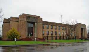
Tillamook County is a county located in the state of Oregon. Based on the 2010 census, the population was 25,250. The county seat is Tillamook. The county is named for the Tillamook, a Native American tribe who were living in the area in the early 19th century at the time of European American settlement.
Etymology - Origin of Tillamook County Name
The Tillamook were the southernmost branch of the Coast Salish. They were separated from their more northern kinsmen by tribes speaking the Chinookian languages. The name Tillamook is of Chinook origin (a trade pidgin, which had developed along the lower Columbia.) According to Frank Boas, "It [Tillamook] means the people of Nekelim. The latter name means the place of Elim, or in the Cathlamet dialect, the place of Kelim. The initial t of Tillamook is the plural article, the terminal ook the Chinook plural ending - uks." Since there was one village in the area of Nehalem bay; the area was referred to as Nekelim (Ne Elim=singular). There were at least four villages on the south Tillamook bay according to Lewis and Clark; the south bay was called "T-Elim-ook" (the plural of Elim), meaning many villages of Elim. (The Chinook word for water was "chuck" and the Salish word for wetland is "naslex". The popular translation of Tillamook as meaning "land of many waters" seems to be 20th-century fabrication used in the tourist industry.)
Demographics:
County QuickFacts: CensusBureau Quick Facts
Tillamook County History
Tillamook County, the twelfth county
in Oregon to be organized, was established on December 15, 1853, when the
Territorial Legislature approved an act to create the new county out of an area
previously included in Clatsop, Yamhill and Polk Counties. The county was named
after the Tillamook Indians who occupied the areas around the Tillamook and
Nehalem Bays.
Tillamook County is located in the northwestern portion of the state and is
bordered by Clatsop County on the north, Washington and Yamhill Counties on the
east, Polk and Lincoln Counties on the south, and by the Pacific Ocean on the
west. Boundary changes were enacted with Clatsop County (1855, 1870, and 1893),
Lincoln County (1893), Washington County (1893, 1898), and Yamhill County
(1887). The area of Tillamook County is 1,125 square miles. The 2000 population
of 24,262 represented an increase of 12.48% since 1990.
During the first ten years following the organization of the county, the county
court met at the homes of its members. From 1865 to 1875 court sessions were
held in various schoolhouses in the district, the exact place being determined
by the incumbent county judge. In 1866 the town of Lincoln was renamed Tillamook
in order to stay consistent with the post office's name of Tillamook. An
election in 1873 chose Tillamook as the county seat. In 1875 the county rented
an office in the general store to house government. In 1889 a courthouse was
built but was destroyed by fire in 1903. Only the county clerk's vault and its
stored records were saved. A new courthouse was built at the same site in 1905
and replaced again in 1933.
County government offices that were already in place upon statehood were the
three county commissioners (including the county judge), a probate judge,
sheriff, clerk, treasurer, assessor, school superintendent, and coroner.
Subsequent officers and/or boards were established as follows: surveyor (1860);
stock inspector (1895); school district boundary board (1899); veterinarian
(1910); health officer (1912); fair board (1913); agricultural agent (1915);
dairy herd inspector (1917); dog control districts (1919); and an engineer
(1925).
The major physical features of Tillamook County consist of the rocky and
irregular coastline that forms the county's western boundary, stretches of
coastal lowlands, and heavily timbered interior parts, which comprise the main
span and several spurs of the Coast Range. Principal industries are agriculture,
lumber, fishing, and recreation. Dairy farms dominate the county's fertile
valleys providing milk for the well-known Tillamook cheese. Logging and
lumbering are becoming a significant economic force due to the reforestation of
most of the "Tillamook Burn" area. With seventy-five miles of coastline, four
bays, and nine rivers, recreational and tourist facilities are numerous. The
Tillamook airbase for blimps was commissioned on December 1, 1942, with the name
US Naval Air Station. It was closed after World War II. Tillamook and Yamhill
counties also hosted the Mt. Hebo Air Force Station, which played an important
part in air defense during the Cold War, from 1956 to 1980.
Geography: Land and Water
As reported by the Census Bureau, the county has a total area of 1,333 square miles (3,450 km2), of which 1,103 square miles (2,860 km2)
is land and 230 square miles (600 km2) (17%) is water. At 3,706 feet (1130 m) in elevation, Rogers Peak is the highest point in the county and
the highest in the Northern Oregon Coast Range.
Neighboring Counties
Bordering counties are as follows:
- Clatsop County - north
- Washington County - east
- Yamhill County - east
- Polk County - southeast
- Lincoln County - south
Education


Click Image to Enlarge
