


Click Image to Enlarge
Oregon Counties
There are thyirty-six counties in the state of Oregon. The Oregon Constitution does not explicitly provide for county seats.Wallowa County, Oregon
Wallowa County Education, Geography, and History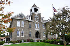
Wallowa County is a county located in the state of Oregon. Based on the 2010 census, the population was 7,008, making it the fourth-least populous county in Oregon. Its county seat is Enterprise. According to Oregon Geographic Names, the origins of the county's name are uncertain, with the most likely explanation being that it is derived from the Nez Perce term for a structure of stakes (a weir) used in fishing. An alternative explanation is that Wallowa is derived from a Nez Perce word for "winding water". The journals of Lewis and Clark Expedition record the name of the Wallowa River as Wil-le-wah.
Etymology - Origin of Wallowa County Name
The Wallowa Mountains are an important geographical feature of the county. They are unlike other mountain ranges in the state due to their granitic rather than volcanic origin. They take their name from the Wallowa River that is formed by the confluence of the east and west forks about a mile south of Wallowa Lake and eventually flows into the Grande Ronde River. Wallowa is a Nez Perce word for "fish trap."
Demographics:
County QuickFacts: CensusBureau Quick Facts
Wallowa County History
Wallowa County was established on
February 11, 1887, out of the eastern portion of Union County. It is the
northeastern most county of Oregon. Subsequent boundary changes occurred in
1890, 1900, and 1915 when land was acquired from or transferred to Union County.
Wallowa County is now bounded on the north by the State of Washington, on the
east by the Snake River which is the boundary with the State of Idaho, on the
south by Baker County, and on the west by Union County. The county's area is
3,153 square miles. Its 2000 population of 7,226 was an increase of 4.56% over
1990.
In 1877 the younger Chief Joseph of the Nez Perce, incensed at the government's
attempt to deprive his people of the Wallowa Valley, refused to be moved to an
Idaho reservation. Several regiments of United States troops were dispatched to
force him onto the reservation. After a number of battles and a thousand-mile
retreat, Chief Joseph was compelled to surrender. He and the remnants of his
band were removed to Oklahoma and later were relocated to a reservation in
Washington State.
The Wallowa Mountains are an important geographical feature of the county. They
are unlike other mountain ranges in the state due to their granitic rather than
volcanic origin. They take their name from the Wallowa River that is formed by
the confluence of the east and west forks about a mile south of Wallowa Lake and
eventually flows into the Grande Ronde River. Wallowa is a Nez Perce word for
"fish trap."
The City of Enterprise serves as the county seat. The City of Joseph was named
the interim county seat until a general election chose Enterprise as the county
seat in 1888. A proposition to contribute to the building of a county courthouse
by sixty citizens was turned down by the county court in 1899. It was not until
1909 that a courthouse was built. Constructed of native stone the building
continues to house county offices. Enterprise, in addition to being the county
seat, is the Wallowa Valley's trade center for ranchers and has local offices
for the Wallowa-Whitman National Forest.
County government consists of a county court made up of a county judge and two
commissioners. Other offices include clerk, sheriff, assessor, treasurer, and
surveyor.
Principal industries in Wallowa County are agriculture, livestock, lumber,
tourism, and recreation.
Geography: Land and Water
Wallowa is the northeastern most county of Oregon. As reported by the Census Bureau, the county has a total area of 3,152 square miles
(8,160 km2), of which 3,146 square miles (8,150 km2) is land and 5.5 square miles (14 km2) (0.2%) is water.
Neighboring Counties
Bordering counties are as follows:
- Umatilla County (west)
- Union County (west)
- Baker County (south)
- Adams County, Idaho (southeast)
- Idaho County, Idaho (east)
- Nez Perce County, Idaho (northeast)
- Asotin County, Washington (north)
- Garfield County, Washington (north)
- Columbia County, Washington (north)
Education


Click Image to Enlarge
