

Click Image to Enlarge
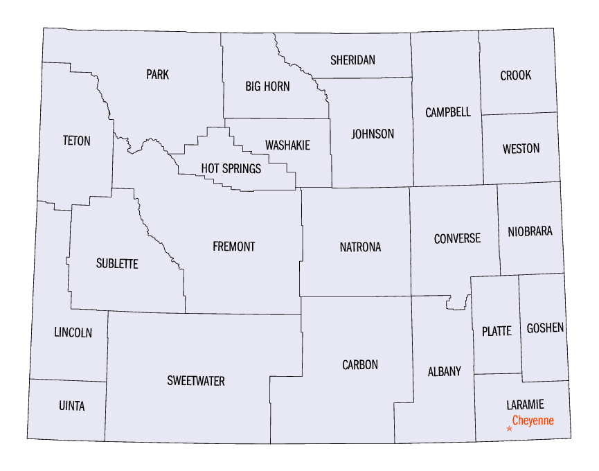
Wyoming Counties
There are twenty-three Counties in the state of Wyoming. There were originally five Counties in the Wyoming Territory: Laramie and Carter, established in 1867; Carbon and Albany established in 1868; and Uinta, an annexed portion of Utah and Idaho, extending from Montana (including Yellowstone Park) to the Wyoming-Utah boundary. On July 10, 1890, Wyoming was admitted to the Union with thirteen counties.Converse County, Wyoming
Converse County Education, Geography, and History
Converse County is a county located in the state of Wyoming. Based on the 2010 census, the population was 13,833. Its county seat is Douglas.
Etymology - Origin of Converse County Name
Named for A. R. Converse, a Cheyenne banker and stockman.
Demographics:
County QuickFacts: CensusBureau Quick Facts
Converse County History
Converse County was organized in 1888. Converse County was established March 9, 1888. It was named after Amasa R.
Converse, a Wyoming pioneer and Cheyenne banker. Converse County was carved from Albany and Laramie Counties. On May 18,
1888 Douglas was voted the county seat.
It was stated in the 1907 anniversary edition of "Bill Barlow's Budget" that there was 6,624 square miles of land in
Converse County. The land extended a distance of 170 miles east and west, and 92 miles north and south at its widest
parts. In 1911 Niobrara County was carved out of Converse County. Presently the county covers approximately 4,200 square
miles.
The First Elected County Officials
The first county officers were elected in 1888, right after Converse became a county. Malcolm Campbell was the Sheriff, C. M. Garver was the Clerk, Ed J. Wells was the Treasurer, F. H. Harvey was the Attorney; F. E. Wolcott, George H. Cross and E. T. David were Commissioners; W. R. Renwick was the Coroner, S. Slaymaker was the Assessor, and A. T. Seymour was the Surveyor.
Geography: Land and Water
As reported by the Census Bureau, the county has a total area of 4,265 square miles (11,047 km2), of which, 4,255 square miles (11,020 km2) of it is land and 10 square miles (27 km2) of it (0.24%) is water
Neighboring Counties
Bordering counties are as follows:
- Campbell County, Wyoming - north
- Weston County, Wyoming - northeast
- Niobrara County, Wyoming - east
- Platte County, Wyoming - southeast
- Albany County, Wyoming - south
- Carbon County, Wyoming - southwest
- Natrona County, Wyoming - west
- Johnson County, Wyoming - northwest
Education


Click Image to Enlarge
