

Click Image to Enlarge
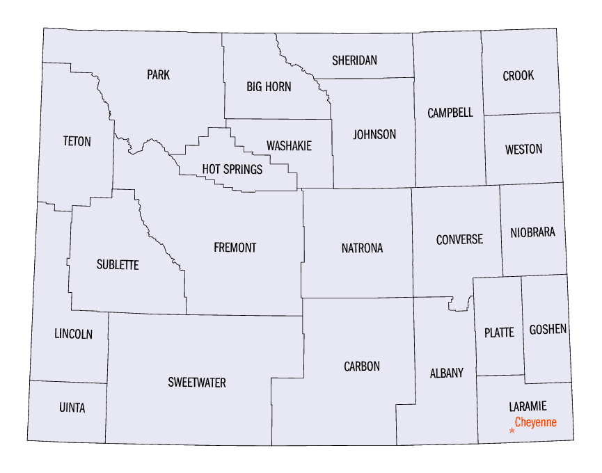
Wyoming Counties
There are twenty-three Counties in the state of Wyoming. There were originally five Counties in the Wyoming Territory: Laramie and Carter, established in 1867; Carbon and Albany established in 1868; and Uinta, an annexed portion of Utah and Idaho, extending from Montana (including Yellowstone Park) to the Wyoming-Utah boundary. On July 10, 1890, Wyoming was admitted to the Union with thirteen counties.Laramie County, Wyoming
Laramie County Education, Geography, and History
Laramie County is a county in the southeastern corner of the state of Wyoming. Based on the 2010 census, the population was 91,738
making it the most populous county in Wyoming. The county seat is Cheyenne, the state capital. The county lies west of the Nebraska state
line and north of the Colorado state line.
Laramie county comprises the Cheyenne, WY Metropolitan Statistical Area. It is the least populous county that is the most populous in a
state.
Etymology - Origin of Laramie County Name
Named for Jacques La Ramie, French-Canadian trapper, who was killed by the Indians near what was later Fort Laramie.
Demographics:
County QuickFacts: CensusBureau Quick Facts
Laramie County History
In July 1858, gold was discovered along the South Platte River in Arapahoe County, Kansas Territory. This discovery precipitated the Pike's Peak Gold Rush. Many residents of the mining region felt disconnected from the remote territorial governments of
Kansas and Nebraska, so they voted to form their own Territory of Jefferson on October 24, 1859. The following month, the Jefferson Territorial Legislature organized 12 counties for the new territory including Cheyenne County. Cheyenne County was named for the Cheyenne Nation of Native Americans
that lived in the area. Cheyenne County encompassed most of present day Laramie County. The Jefferson Territory never received federal sanction.
On July 25, 1868, the Territory of Wyoming was organized. Laramie County was organized in 1867.
Geography: Land and Water
As reported by the Census Bureau, the county has a total area of 2,688 square miles (6,961 km2), of which, 2,686 square miles (6,957 km2) of it is land and 2 square miles (4 km2) of it (0.06%) is water.
Laramie County is located in the southeast corner of Wyoming and shares a border with Nebraska to the east and Colorado to the south. It is at the crossroads of two major interstate highways and two major railroads. Residents enjoy a stable, growing economy, a high-quality of life, excellent educational system and a low tax structure. Laramie County ranks first in population and fifteenth in area when compared to the other twenty-two counties in Wyoming.
Neighboring Counties
Bordering counties are as follows:
- Goshen County (north-northeast)
- Banner County, Nebraska (northeast)
- Kimball County, Nebraska (east)
- Weld County, Colorado (south)
- Larimer County, Colorado (southwest)
- Albany County (west)
- Platte County (north-northwest)
Education


Click Image to Enlarge
