

Click Image to Enlarge
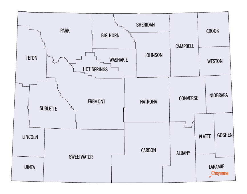
Wyoming Counties
There are twenty-three Counties in the state of Wyoming. There were originally five Counties in the Wyoming Territory: Laramie and Carter, established in 1867; Carbon and Albany established in 1868; and Uinta, an annexed portion of Utah and Idaho, extending from Montana (including Yellowstone Park) to the Wyoming-Utah boundary. On July 10, 1890, Wyoming was admitted to the Union with thirteen counties.Lincoln County, Wyoming
Lincoln County Education, Geography, and History
Lincoln County is a county in the state of Wyoming. Based on the 2010 census, the population was 18,106. Its county seat is Kemmerer. It is east from the Idaho-Utah state line.
Etymology - Origin of Lincoln County Name
Named in honor of Abraham Lincoln, 16th President of the United States.
Demographics:
County QuickFacts: CensusBureau Quick Facts
Lincoln County History
Organized from Uinta in 1913. First individuals came as trappers, explorers, and settlers. Oregon, Mormon and California Trails cross this area. The county covers from the West border of Wyoming past Opal and From Afton South of Kemmerer. The major industries are ranching, farming, mining, gas and oil production, and numerous production plants. Bridger National Forest covers part of Lincoln County. Fossil Butte National Monument is located west of Kemmerer and is a large collection for public view of Fossils. The road from Kemmerer to Afton is one of the major routes to Yellowstone National Park. The area has mountains, desert, and farm land. The terrain is ever changing and beautiful with something for all individuals.
Timeline
- 1811 Hoback Canyon and River named
- 1824 Ham's Fork named
- 1829 La Barge named
- 1842 Fort Bridger established
- 1850 California becomes a state
- 1853 Fort Supply established
- 1858 Fort Bridger becomes a military post
- 1867 Union Pacific Railroad crosses Wyoming
- 1868 Diamondville established
- 1869 Wyoming Territory formed
- Evanston established
- (1 Dec) Uinta County created. It included the present day counties of Teton, Lincoln Uinta, and half of Sublette. The town of Merril was named the County Seat for a short time after the creation of the county. Evanston was then named the County Seat.
- 1870 U. S. Census of Wyoming Uinta County population of 856
- 1872 (1 Mar) Congress created Yellowstone Park
- 1873 Evanston Incorporated
- 1874 Cokeville established
- 1876 Evanston Land Office opened
- 1879 Settlements of Freedom, Stumpp Creek(Auburn) in Salt River Valley (Star Valley) started
- First cabin built
Geography: Land and Water
As reported by the Census Bureau, the county has a total area of 4,089 square miles (10,590 km2), of which,
4,069 square miles (10,539 km2) of it is land and 20 square miles (52 km2) of it (0.49%) is water
Neighboring Counties
Bordering counties are as follows:
- Teton County (north)
- Sublette County (northeast)
- Sweetwater County (east)
- Uinta County (south)
- Rich County, Utah (southwest)
- Bear Lake County, Idaho (west)
- Caribou County, Idaho and Bonneville County, Idaho (northwest)
Education


Click Image to Enlarge
