

Click Image to Enlarge
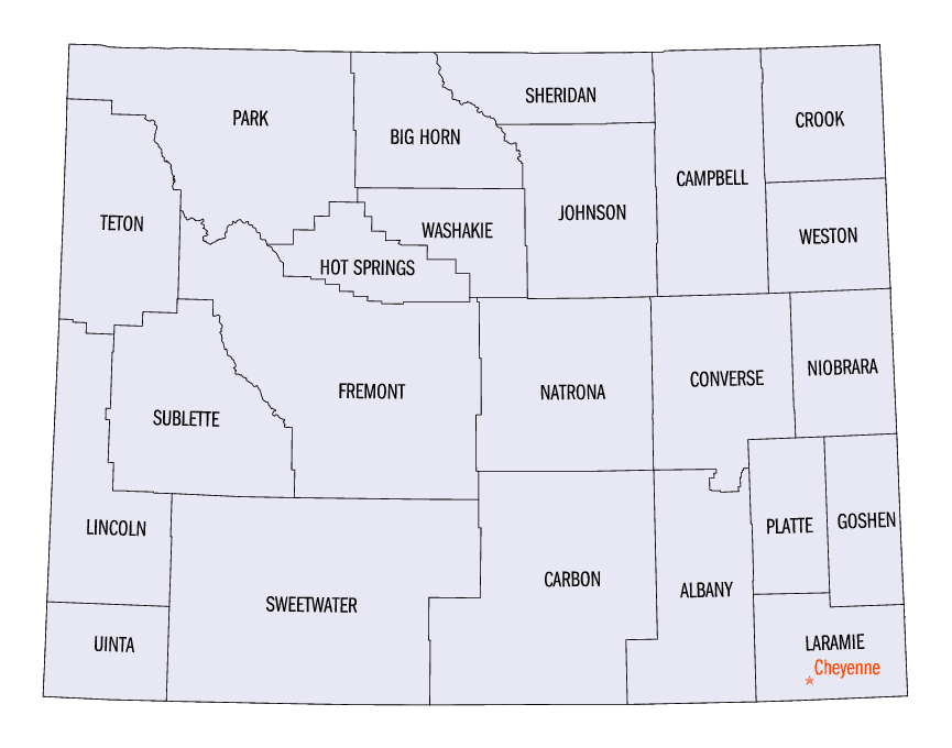
Wyoming Counties
There are twenty-three Counties in the state of Wyoming. There were originally five Counties in the Wyoming Territory: Laramie and Carter, established in 1867; Carbon and Albany established in 1868; and Uinta, an annexed portion of Utah and Idaho, extending from Montana (including Yellowstone Park) to the Wyoming-Utah boundary. On July 10, 1890, Wyoming was admitted to the Union with thirteen counties.Niobrara County, Wyoming
Niobrara County Education, Geography, and History
Niobrara County is a county located in the state of Wyoming. Based on the 2010 census, the population was 2,484, making it the least populous county in Wyoming. Its county seat is Lusk. It is west from the Nebraska-South Dakota state line.
Etymology - Origin of Niobrara County Name
Takes its name from the Niobrara River. Niobrara, from the Omaha Indian language, signifies "flat" or "broad" river.
Demographics:
County QuickFacts: CensusBureau Quick Facts
Niobrara County History
Niobrara County, WY was created in 1911 from the eastern part of Converse County, WY. It was organized in 1913 and
named by Harry S. Snyder after the Niobrara River which rises west of Lusk, Niobrara County seat.
The name "Niobrara" is taken from the Omaha-Ponca Indian name Ni (water) obthatha (spreading) ke (horizontally). It was
called "Running Water" by early settlers. The Cheyenne Indian name for the Niobrara was Hisse yovi yoe, which means
unexpected or surprise river. They came upon it suddenly on the prairie, as it is marked with few trees.
Lusk, WY
The Niobrara County seat, is located in Eastern Wyoming in the tall grass country and is served by highways
connecting in all four directions. Only 3,200 people live in rural Niobrara County, averaging out to almost 524
acres per person. As a ranching community, Lusk has a relatively stable economic base. Lusk was named for Frank
Lusk, an early rancher who donated land for the town site. Today, it is a trading center for a ranching and
dry-farming district which is somewhat involved in oil production. To the west of Lusk are red-colored cliffs from
which Native Americans obtained material for paint. Through this area ran the Cheyenne and Black Hills Stage Line,
whose route is marked by two rows of white posts.
Three miles east on US 20, a marker indicates the location of a segment of the Texas Trail. The trail was used to
herd cattle from Texas to the open ranges of Wyoming, Montana and the Dakotas. Lusk, Manville and Van Tassel are
incorporated municipalities of Niobrara County, while Lance Creek, an unincorporated community, is also in Niobrara
County.
Geography: Land and Water
Located along the eastern corridor of Wyoming, 240 miles north of Denver; US Highways 18 & 20 intersect at Lusk, the county seat. The town of Manville is located 10 miles west, and the town of of Van Tassell is located 15 miles east of Lusk.
Neighboring Counties
Bordering counties are as follows:
- Weston County (north)
- Custer County, South Dakota (northeast)
- Fall River County, South Dakota (east)
- Sioux County, Nebraska (southeast)
- Goshen County (south)
- Platte County (southwest)
- Converse County (west)
Education


Click Image to Enlarge
