


Click Image to Enlarge
Colorado Counties
Colorado currently has sixty-four counties. In February 1866, the first new county, Las Animas, was created. Alamosa was created in 1913, and in 2001, Broomfield was recognized as a city-county, bringing a total of 64 counties.Adams County, Colorado
Adams County Education, Geography, and History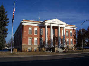
Adams County is the fifth-most populous of the 64 counties of the state of Colorado. Based on the 2010 census, the
population was 441,603. The
county seat is Brighton. The county was
created on April 15, 1901 from Arapahoe County. Adams county is
named for Alva Adams, Governor of the State of Colorado.
Adams County is part of the Denver-Aurora-Lakewood, CO Metropolitan Statistical Area.
Etymology - Origin of Adams County Name
The county is named in honor of Alva Adams, the 5th, 10th, and 14th Governor of the State of Colorado
Demographics:
County QuickFacts: CensusBureau Quick Facts
Adams County History
Adams County is the fifth most populous of the 64 counties of the State of Colorado of the United States. Adams County is named for Alva Adams, a former Governor of Colorado. The county seat is Brighton. Adams County is part of the Denver-Aurora Metropolitan Statistical Area and the Denver-Aurora-Boulder Combined Statistical Area.
The Kansas-Nebraska Act created the Territory of Nebraska and Territory of Kansas, divided by the Parallel 400 North (168th Avenue in present-day Adams County)
on May 30, 1854. The future Adams County, Colorado, occupied a strip of northern Arapahoe
County, Kansas Territory, immediately south of the Nebraska Territory.
John D. "Colonel Jack" Henderson built a ranch, trading post, and hotel on Henderson Island in the South Platte River in Arapahoe County, Kansas Territory
in 1859. Jack Henderson was the former editor and proprietor of the Leavenworth (Kansas Territory) Journal
he was an outspoken pro-slavery
politician who had been accused of vote fraud in eastern Kansas. Henderson sold meat and provisions to gold seekers on their way up the South Platte River Trail to the gold fields during the Pike's Peak Gold Rush. Henderson Island was the first permanent settlement in the South Platte River Valley
between Fort Saint Vrain in the Nebraska Territory and the Cherry Creek Diggings in the Kansas Territory. Jack Henderson eventually returned to eastern Kansas and fought for the Union in the American Civil War. Henderson Island is today the site of the Adams County Regional Park and
Fairgrounds.
The eastern portion of the Kansas Territory was admitted to the Union as the State of Kansas on January 29, 1861, and on February 28, 1861, the remaining western portion of the territory was made part of the new Colorado Territory. The
Colorado Territory created Arapahoe County, on November 1, 1861, and Colorado was admitted to the Union on August 1,
1876.
In 1901, the Colorado General Assembly voted to split Arapahoe County into three parts: a new Adams County, a new consolidated City and County of Denver, and the remainder of the Arapahoe County to be renamed South Arapahoe County. A ruling by the Colorado Supreme Court, subsequent legislation, and
a referendum delayed the creation of Adams County until November 15, 1902. Governor James Bradley Orman designated Brighton as the temporary Adams County Seat. Adams County originally stretched 160 miles (258 kilometers) from present-day Sheridan Boulevard to the Kansas state border. On May 12,
1903, the eastern 88 miles (142 kilometers) of Adams County was transferred to the new Washington County and the new Yuma County, reducing the length of Adams County to the present 72 miles (116 kilometers). Adams County voters chose Brighton as the permanent county seat
on November 8, 1904.
A 1989 vote transferred 53 square miles (137 square kilometers) of Adams County to the City and County of Denver for the proposed Denver International Airport.
Geography: Land and Water
As reported by the Census Bureau, the county has a total area of 1,198 square miles (3,102 km2),
of which, 1,192 square miles (3,087 km2) of it is land and 6 square miles (15 km2) of it (0.48%) is
water.
Adams County is located in northeastern Colorado. The county surrounds most of Denver International Airport which is in
the City and County of Denver, Colorado. Adams County lost the tip of its northwest
corner when the consolidated City and County of Broomfield was created on November 15, 2001. The county is 18
miles wide and 72 miles long. The county ranges from urban in the
western portions of the county, to crop and grazing land in the
central and eastern portions.
Neighboring Counties
Bordering counties are as follows:
- North: Weld County
- Northeast: Morgan County
- East: Washington County
- South: Arapahoe County
- Southwest: Jefferson County; Denver city & county
- Northwest: Boulder County
Education
The school districts serving Adams County are:
- Adams 12 Five Star Schools
- Adams County 14
- Bennett 29J
- Brighton 27J
- Mapleton 1
- Strasburg 31J
- Westminster 50


Click Image to Enlarge
