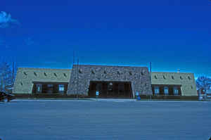
Conejos County, Colorado
Conejos County Education, Geography, and History
Conejos County is one of the 64 counties of the state of Colorado. Based on the 2010 census, the population was 8,256. The county seat is the unincorporated community of Conejos. Conejos County was created on November 1, 1861 one of the 17 original counties of the Territory of Colorado. The county is named after cottontail rabbits in the area. Conejos is a Spanish word for rabbits.
Etymology - Origin of Conejos County Name
Conejos County is named from the Spanish word for rabbits, as cottontail rabbits are abundant in the area.
Demographics:
County QuickFacts: CensusBureau Quick Facts
Conejos County History
Conejos County was one of the original 17 counties created by the General Assembly of the Territory of Colorado on
November 11, 1861. The county was originally named Guadalupe County and renamed Conejos County a week later, on November 7.
Its name coming from the Spanish term Conejos, meaning rabbit, for the large abundance of rabbits in the area.
Early
in its existence, the county seat was moved from the town of Guadalupe to Conejos. The original boundaries of the county
included a large portion of southwestern Colorado.
In 1874, most of the western and northern portions of the county were taken away to form parts of Hinsdale, La Plata
and Rio Grande counties. Conejos County achieved its modern borders in 1885 when its western half was taken to
create Archuleta County.
Geography: Land and Water
As reported by the Census Bureau, the county has a total area of 1,291 square miles (3,343 km2), of which, 1,287 square miles (3,334 km2) of it is land and 4 square miles (9 km2) of it (0.28%) is water.
Conejos County is located in southern Colorado, in the San Luis
Valley. The eastern part of the county is defined by the nearly level
valley floor of about 7,700 feet elevation. San Juan Mountains climb
from the western portion of the county to a height of about 13,000 feet.
Conejos County is surrounded by the Rio Grande (River) to the east and
the State of New Mexico to the south. Wide open farms and pasturelands
describe the remaining of the land that is privately owned. The Rio
Grande, the Conejos, Alamosa, and San Antonio Rivers and La Jara Creek
crisscross the county.
Neighboring Counties
Bordering counties are as follows:
- Northeast: Alamosa County
- East: Costilla County
- Southeast: Taos County, N.M.
- Southwest: Rio Arriba County, N.M.
- West: Archuleta County
- Northwest: Rio Grande County
Education


