


Click Image to Enlarge
Colorado Counties
Colorado currently has sixty-four counties. In February 1866, the first new county, Las Animas, was created. Alamosa was created in 1913, and in 2001, Broomfield was recognized as a city-county, bringing a total of 64 counties.El Paso County, Colorado
El Paso County Education, Geography, and History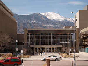
El Paso County is one of the 64 counties of the state of Colorado. As of the 2014 Census, the
population was 663,519. The Census
Bureau's 2014 estimate indicates it is the second most populous county in Colorado, after the City and County of Denver. The
county seat is
Colorado Springs, the second most populous city in Colorado. El Paso
County was created on November 1, 1861 as one of the 17
original counties of the Territory of Colorado. The county is
named after Ute Pass in the county. El Paso is a Spanish
expression for the pass.
El Paso County is included in the Colorado Springs, CO Metropolitan Statistical Area.
Etymology - Origin of El Paso County Name
El Paso County was named for the Spanish language name for Ute Pass north of Pikes Peak.
Demographics:
County QuickFacts: CensusBureau Quick Facts
El Paso County History
In July 1858, gold was discovered along the South Platte River in Arapahoe County, Kansas Territory. This discovery
hastened the Pike's Peak Gold Rush. Several residents of the mining region felt
detached from the remote territorial governments of
Kansas and Nebraska, so they voted to form their own Territory of Jefferson on
October 24,1859. The following month, the Jefferson Territorial Legislature organized 12 counties for the new territory including El Paso County. El Paso County was named for the Spanish language name for Ute Pass north of
Pikes Peak. Colorado City served as the county seat of El Paso County.
The Jefferson Territory did not receive federal sanction, but on February 28,1861, US President James Buchanan signed an act organizing the Territory of Colorado. El Paso County was one of the original 17 counties created by the Colorado legislature on November 1, 1861. Part of
the western territory was used to create Teller County in 1899. Originally based in Old Colorado City (now part of Colorado Springs, not today's Colorado City between Pueblo and Walsenburg), El Paso County's county seat was moved to Colorado Springs in 1873.
Geography: Land and Water
As reported by the Census Bureau, the county has a total area of 2,130 square miles (5,516 km2), of which 2,126 square miles (5,507 km2) is land and 3 square miles (8 km2)(0.15%) is water.
El Paso county is located close to the center of Colorado. The western portion of El Paso County is very mountainous, the
eastern part is prairie land where dairy cows and beef cattle are
raised.
Neighboring Counties
Bordering counties are as follows:
- Northeast: Elbert County
- East: Lincoln County
- Southeast: Crowley County
- South: Pueblo County
- Southwest: Fremont County
- West: Teller County
- Northwest: Douglas County
Education


Click Image to Enlarge
