


Click Image to Enlarge
Colorado Counties
Colorado currently has sixty-four counties. In February 1866, the first new county, Las Animas, was created. Alamosa was created in 1913, and in 2001, Broomfield was recognized as a city-county, bringing a total of 64 counties.Montrose County, Colorado
Montrose County Education, Geography, and History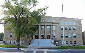
Montrose County is one of the 64 counties of the state of Colorado. Based on the 2010 census, the
population was 41,276. The county
seat
is Montrose. Montrose County was created on February
11, 1883 from Gunnison County. The county is named for
the city of Montrose.
Montrose County comprises the Montrose, CO Micropolitan Statistical Area.
Etymology - Origin of Montrose County Name
Montrose County is named for the City of Montrose, which in turn was named probably from the novel A Legend of Montrose, published in 1819 by Sir Walter Scott.
Demographics:
County QuickFacts: CensusBureau Quick Facts
Montrose County History
Montrose County was created in 1883 from part of Gunnison County.
Geography: Land and Water
As reported by the Census Bureau, the county has a total area of 2,243 square miles (5,808 km2), of which, 2,241 square miles (5,803 km2) of it is land and 2 square miles (5 km2) of it (0.09%) is water.
Montrose county is located in west Colorado. The Great Parks Bicycle
Route, Unaweep/Tabeguache Scenic and Historic Byway, West Elk Loop
Scenic Byway and Western Express Bicycle Route are located in Montrose
county.
Neighboring Counties
Bordering counties are as follows:
- Northeast: Delta County; Gunnison County
- Southeast: Ouray County
- Southwest: San Miguel County; San Juan County, Utah
- Northwest: Grand County, Utah; Mesa County
Education


Click Image to Enlarge
