


Click Image to Enlarge
Colorado Counties
Colorado currently has sixty-four counties. In February 1866, the first new county, Las Animas, was created. Alamosa was created in 1913, and in 2001, Broomfield was recognized as a city-county, bringing a total of 64 counties.Ouray County, Colorado
Ouray County Education, Geography, and History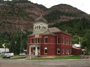
Ouray County is one of the 64 counties of the state of Colorado. Based on the 2010 census, the population was 4,436. The county seat is Ouray. Ouray County was establish created on January 18, 1877 from Hinsdale County and Lake County. The county is named in honor of Ouray, a Ute Native American leader.
Etymology - Origin of Ouray County Name
Ouray County is named in honor of Ouray, a Ute Native American leader.
Demographics:
County QuickFacts: CensusBureau Quick Facts
Ouray County History
Ouray County was created in 1877 from part of San Juan with a small piece of Hinsdale added. In 1881 the southern portion was split off to form Dolores County. The western part became San Miguel County in 1883 and Ouray County was briefly renamed Uncompahgre County.
Geography: Land and Water
As reported by the Census Bureau, the county has a total area of 542 square miles (1,404 km2), of which, 540 square miles (1,400 km2) of it is land and 2 square miles (5 km2) of it (0.32%) is water.
Ouray county is located in southwest Colorado. Because
of its rugged mountain topography, Ouray County is also known as the
Switzerland of America.
Neighboring Counties
Bordering counties are as follows:
- Northeast: Gunnison County
- Southeast: Hinsdale County
- South: San Juan County
- Southwest: San Miguel County
- Northwest: Montrose County
Education


Click Image to Enlarge
