


Click Image to Enlarge
Indiana Counties
Indiana is divided into ninety-two counties. The oldest and newest Counties in Indiana are Knox County (created 1790) and Newton County (created 1857).Many Indiana counties are named for the US Founding Fathers and personalities of the American Revolutionary War, the War of 1812 and Battle of Tippecanoe; early leaders of Indiana Territory and Indiana, as well as surrounding states like Michigan and Kentucky; plus Native American tribes and geographical features.Warren County, Indiana
Warren County Education, Geography, and History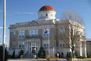
Warren County lies in western Indiana. According to the 2010
census, the population was 8,508. Warren County was
created on March 1, 1827. The county
seat is Williamsport. The county is named
for Dr. Joseph Warren, American Revolutionary War hero.
Etymology - Origin of Warren County Name
The county is named for Revolutionary War hero General Joseph Warren, who fell in the Battle of Bunker Hill.
Demographics:
County QuickFacts: CensusBureau Quick Facts
Warren County History
Before the arrival of non-indigenous settlers in the early 19th century, the area was inhabited by several Native American tribes. The county was established March 1, 1827 by the Indiana General Assembly. It was named for Dr. Joseph Warren, killed in 1775 at the Battle of Bunker Hill, in which he fought as a private because his commission as a general had not yet taken effect. The short-lived town of Warrenton was the original Warren County seat, chosen by commissioners in March 1828. The next year, however, an act was passed calling for it to be relocated, and in June 1829 it was moved to Williamsport.
It is one of the most rural counties in the state, with the third-smallest population and the lowest population density at about 23
inhabitants per square mile (8.9/km2). The county has four incorporated towns with a total population of about 3,100,as well as many small
unincorporated communities. The county is divided into 12 townships which provide local services
Williamsport was, from 1879 to 1896, the home of James Frank Hanly, who was the Governor of Indiana from 1905 to 1909.
Geography: Land and Water
As reported by the Census Bureau, the county has a total area of 367 square miles (949 km2); 365 square miles (945 km2) of it is land and 2 square miles (4 km2) of it (0.47%) is water.
Warren county is located in northwest Indiana. Along the southeastern border of this county, the terrain is hilly and wooded. The northwest region is made up mainly of flat prairie farmland. The highest free-falling waterfall in the state, Williamsport Falls, is located in this county.
Neighboring Counties
Bordering counties are as follows:
- North: Benton County
- East: Tippecanoe County
- Southeast: Fountain County
- South: Vermillion County
- Southwest: Vermilion County, Ill.
Education
The county's four public schools are administered by the Metropolitan School District of Warren County


Click Image to Enlarge
